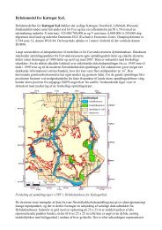
Automatic generation of elevation data over Danish landscape
Automatic generation of elevation data over Danish landscape
Automatic generation of elevation data over Danish landscape

You also want an ePaper? Increase the reach of your titles
YUMPU automatically turns print PDFs into web optimized ePapers that Google loves.
C.1.3.3 Calculation options<br />
C.1 Description <strong>of</strong> the analysis programme PIL<br />
To make the programme run, a work directory c:/work, and a result directory c:/res must be established.<br />
There are three different calculation options in the programme. The wanted calculation is chosen by the<br />
user by marking:<br />
1) Analysis and cut-out<br />
2) Analysis and cut-out after local <strong>of</strong>fset<br />
3) Analysis and input reference file > level 3<br />
1) Analysis and cut-out<br />
With the calculation option ”Analysis and cut-out”, a differential calculation is done, and the statistical <strong>data</strong><br />
is calculated. All differences, which numerically exceed the gross error limit determined in level 3, are cut<br />
out. If this calculation method is chosen, the cut-outs are done numerically without regard to a possible<br />
<strong>of</strong>fset.<br />
If all points are to be included, the gross error limit in level 3 is set so high that there will be no differences<br />
larger than this value.<br />
2) Analysis and cut-out after local <strong>of</strong>fset<br />
If the choice is to do the calculation with the option ”Analysis and cut-out after local <strong>of</strong>fset”, a possible <strong>of</strong>fset<br />
is determined first, and the cut-out is then done numerically from this <strong>of</strong>fset.<br />
If all points are to be included, level 3 is set higher than the greatest difference.<br />
3) Analysis and input reference file > level 3<br />
If this calculation option is chosen, the <strong>elevation</strong> differences are determined. Points, where the <strong>elevation</strong><br />
differences are numerically larger than the gross error limit indicated in level 3 after shift <strong>of</strong> <strong>of</strong>fset, are<br />
taken out, and <strong>elevation</strong> <strong>data</strong> from the reference file is put in instead <strong>of</strong> the grid point from the test file. For<br />
example, a new, generated <strong>elevation</strong> model (test file) may be compared to an existing model (reference<br />
file), and in case there is a difference in <strong>elevation</strong>s greater than the value in level 3, <strong>elevation</strong> <strong>data</strong> from<br />
the existing <strong>elevation</strong> model are put in. As reference file, the existing <strong>elevation</strong> model from the National<br />
Survey and Cadastre might be used.<br />
In case the two grids are not coincident, a bi-linear interpolation is done to move the grid points from the<br />
reference file to the grid position for the test file.<br />
A new grid file is generated which includes the automatically generated points plus put-in points. The new<br />
grid file is placed in c:/work. It is then possible to compare this new grid file with the analytically determined<br />
reference file. This <strong>of</strong>fers an opportunity <strong>of</strong> analysing how good an accuracy can be achieved, if<br />
grid points from an existing <strong>elevation</strong> model are included.<br />
If, for example, a poor accuracy is achieved by the inclusion <strong>of</strong> the NS&C <strong>elevation</strong>s, it is still possible to<br />
avoid putting in the NS&S <strong>elevation</strong> <strong>data</strong> by using calculation option 2). This results in a grid full <strong>of</strong> holes,<br />
where the cut-out points lie in the file ”Udklip.txt” or by self-chosen indication with the ending ”*ukl.txt.”. In<br />
the files ”Udklip.txt” or ”*ukl.txt”, the cut-out points are found in list format. In the file ”Dummy.asc”, the<br />
points in GeoCAD format are found. The external points will be assigned the <strong>landscape</strong> code 00 in here.<br />
It is then possible to re-measure these points.<br />
Use marked<br />
For all three calculations options, it is possible to add ”use marked”. If an interpolation is included, the grid<br />
point out <strong>of</strong> the four, which has an <strong>elevation</strong> difference larger than the one chosen in level 3, is cut out<br />
(marked by the computer). This point will not be included in the interpolation <strong>of</strong> the neighbouring point. If<br />
181