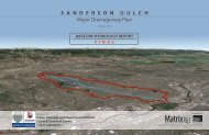
Phase A - Alternatives Analysis Report - Urban Drainage and Flood ...
Phase A - Alternatives Analysis Report - Urban Drainage and Flood ...
Phase A - Alternatives Analysis Report - Urban Drainage and Flood ...

Create successful ePaper yourself
Turn your PDF publications into a flip-book with our unique Google optimized e-Paper software.
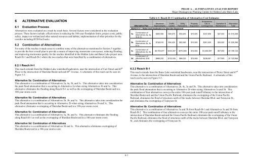
PHASE A – ALTERNATIVES ANALYSIS REPORTMajor <strong>Drainage</strong>way Planning Update for Hidden Lake-Bates Lake6 ALTERNATIVE EVALUATION6.1 Evaluation Process<strong>Alternatives</strong> were evaluated on a reach by reach basis. Several factors were considered in the evaluationprocess. These factors include: effectiveness in reducing the 100-year floodplain limits, project costs, publicsafety, impact on wetl<strong>and</strong> <strong>and</strong> other natural resources <strong>and</strong> habitat, implementation of other priorities for thecorridor including RTD/FasTracks.6.2 Combination of <strong>Alternatives</strong>For some of the reaches it made sense to combine some of the alternatives mentioned in Section 5 togetherto provide the best overall plan to provide a means of improving stormwater conveyance, reducing flooding,<strong>and</strong> improving stormwater quality for the reaches identified in the Hidden Lake <strong>and</strong> Bates Lake project area.Reach H-1 <strong>and</strong> Reach B-1 where the two reaches that were benefited by a combination of alternatives.6.2.1 Reach H-1This reach extends from the Hidden Lake watershed headwaters, near the intersection of Carr Street <strong>and</strong> 69 thPlace to the intersection of Sheridan Boulevard <strong>and</strong> 69 th Avenue. A schematic of this reach can be seen onFigure 5-1.Alternative 5a: Combination of <strong>Alternatives</strong>This alternative is a combination of <strong>Alternatives</strong> 2a, 4a, 3b, <strong>and</strong> 3c. This alternative takes into considerationthe peak flood attenuation that is occurring in Alternative 2a when sizing <strong>Alternatives</strong> 3b <strong>and</strong> 3c. Thisalternative eliminates the flooding along Reach H-1 as well as the overtopping of Sheridan Boulevard in a100-year storm event.Alternative 5b: Combination of <strong>Alternatives</strong>This alternative is a combination of <strong>Alternatives</strong> 2b, 3b, <strong>and</strong> 3c. This alternative takes into consideration thepeak flood attenuation that is occurring in Alternative 2b when sizing <strong>Alternatives</strong> 3b <strong>and</strong> 3c. Thisalternative eliminates overtopping of Sheridan Boulevard in a 100-year storm event.Alternative 5c: Combination of <strong>Alternatives</strong>This alternative is a combination of <strong>Alternatives</strong> 3a, 3b, <strong>and</strong> 3c. This alternative eliminates the floodingalong Reach H-1 as well as the overtopping of Sheridan Boulevard in a 100-year storm event.Alternative 5d: Combination of <strong>Alternatives</strong>This alternative is a combination of <strong>Alternatives</strong> 3b <strong>and</strong> 3c. This alternative eliminates overtopping ofSheridan Boulevard in a 100-year storm event.Alternative PlanTable 6-1: Reach H-1 Combination of <strong>Alternatives</strong> Cost EstimatesStructuralImprovementsTrafficControlUtilityRelocationsREACH H-1: Watershed Headwaters to Sheridan Boulevard5a5b5c5dCombination of<strong>Alternatives</strong> 2a, 4a,3b & 3c.Combination of<strong>Alternatives</strong> 2b, 3b& 3c.Combination ofalternatives 3a, 3b,& 3c.Combination ofalternatives 3b &3c.PropertyAcquisitionEngineering,CM, &ContingenciesOperation &MaintenanceAlternativeTotal$965,596 $89,975 $59,983 $15,585 $337,959 $47,000 $1,516,098$746,915 $94,420 $62,946 $15,585 $261,420 $24,000 $1,205,286$4,705,677 $303,307 $470,568 $15,585 $1,646,987 $57,000 $7,199,124$680,232 $102,035 $68,023 $15,585 $238,081 $17,000 $1,120,9566.2.2 Reach B-1This reach extends from the Bates Lake watershed headwaters, near the intersection of Pierce Street <strong>and</strong> 67 thAvenue, to the intersection of Sheridan Boulevard <strong>and</strong> the Union Pacific Railroad. A schematic of thisreach can be seen on Figure 5-5.Alternative 5a: Combination of <strong>Alternatives</strong>This alternative is a combination of <strong>Alternatives</strong> 2b, 4c, 3a <strong>and</strong> 3b. This alternative takes into considerationthe peak flood attenuation that is occurring in Alternative 2b when sizing <strong>Alternatives</strong> 3a <strong>and</strong> 3b. Thiscombination of four alternatives conveys the entire 100-year peak runoff tributary to the intersection ofSheridan Boulevard <strong>and</strong> the Union Pacific Railroad, eliminates the overtopping of the Union PacificRailroad, eliminates the flood of structures north of the tracks between Sheridan Blvd. <strong>and</strong> Tennyson St.,<strong>and</strong> eliminates the overtopping of Tennyson St.Alternative 5b: Combination of <strong>Alternatives</strong>This alternative is a combination of <strong>Alternatives</strong> 3a <strong>and</strong> 3b from Reach B-1 <strong>and</strong> <strong>Alternatives</strong> 3a <strong>and</strong> 3b fromReach B-2. This combination of four alternatives conveys the entire 100-year peak runoff tributary to theintersection of Sheridan Boulevard <strong>and</strong> the Union Pacific Railroad, eliminates the overtopping of the UnionPacific Railroad, eliminates the flood of structures north of the tracks between Sheridan Blvd. <strong>and</strong> TennysonSt., <strong>and</strong> eliminates the overtopping of Tennyson St.6-1