Hawaii and the Pacific Islands - U.S. Army Corps of Engineers
Hawaii and the Pacific Islands - U.S. Army Corps of Engineers
Hawaii and the Pacific Islands - U.S. Army Corps of Engineers

You also want an ePaper? Increase the reach of your titles
YUMPU automatically turns print PDFs into web optimized ePapers that Google loves.
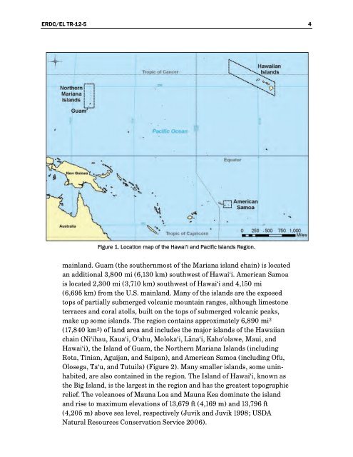
ERDC/EL TR-12-5 4Figure 1. Location map <strong>of</strong> <strong>the</strong> Hawai‘i <strong>and</strong> <strong>Pacific</strong> Isl<strong>and</strong>s Region.mainl<strong>and</strong>. Guam (<strong>the</strong> sou<strong>the</strong>rnmost <strong>of</strong> <strong>the</strong> Mariana isl<strong>and</strong> chain) is locatedan additional 3,800 mi (6,130 km) southwest <strong>of</strong> Hawai‘i. American Samoais located 2,300 mi (3,710 km) southwest <strong>of</strong> Hawai‘i <strong>and</strong> 4,150 mi(6,695 km) from <strong>the</strong> U.S. mainl<strong>and</strong>. Many <strong>of</strong> <strong>the</strong> isl<strong>and</strong>s are <strong>the</strong> exposedtops <strong>of</strong> partially submerged volcanic mountain ranges, although limestoneterraces <strong>and</strong> coral atolls, built on <strong>the</strong> tops <strong>of</strong> submerged volcanic peaks,make up some isl<strong>and</strong>s. The region contains approximately 6,890 mi 2(17,840 km 2 ) <strong>of</strong> l<strong>and</strong> area <strong>and</strong> includes <strong>the</strong> major isl<strong>and</strong>s <strong>of</strong> <strong>the</strong> <strong>Hawaii</strong>anchain (Ni‘ihau, Kaua‘i, O‘ahu, Moloka‘i, Lāna‘i, Kaho‘olawe, Maui, <strong>and</strong>Hawai‘i), <strong>the</strong> Isl<strong>and</strong> <strong>of</strong> Guam, <strong>the</strong> Nor<strong>the</strong>rn Mariana Isl<strong>and</strong>s (includingRota, Tinian, Aguijan, <strong>and</strong> Saipan), <strong>and</strong> American Samoa (including Ofu,Olosega, Ta‘u, <strong>and</strong> Tutuila) (Figure 2). Many smaller isl<strong>and</strong>s, some uninhabited,are also contained in <strong>the</strong> region. The Isl<strong>and</strong> <strong>of</strong> Hawai‘i, known as<strong>the</strong> Big Isl<strong>and</strong>, is <strong>the</strong> largest in <strong>the</strong> region <strong>and</strong> has <strong>the</strong> greatest topographicrelief. The volcanoes <strong>of</strong> Mauna Loa <strong>and</strong> Mauna Kea dominate <strong>the</strong> isl<strong>and</strong><strong>and</strong> rise to maximum elevations <strong>of</strong> 13,679 ft (4,169 m) <strong>and</strong> 13,796 ft(4,205 m) above sea level, respectively (Juvik <strong>and</strong> Juvik 1998; USDANatural Resources Conservation Service 2006).