the use of lidar technology in autonomous cruise control systems for ...
the use of lidar technology in autonomous cruise control systems for ...
the use of lidar technology in autonomous cruise control systems for ...

You also want an ePaper? Increase the reach of your titles
YUMPU automatically turns print PDFs into web optimized ePapers that Google loves.
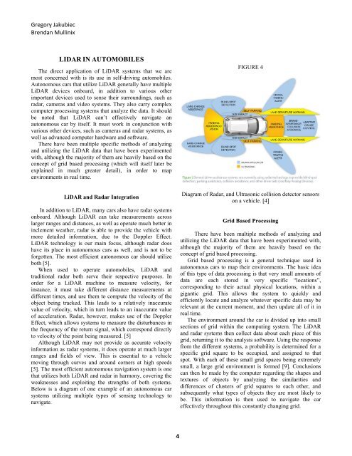
Gregory JakubiecBrendan Mull<strong>in</strong>ixLIDAR IN AUTOMOBILESThe direct application <strong>of</strong> LiDAR <strong>systems</strong> that we aremost concerned with is its <strong>use</strong> <strong>in</strong> self-driv<strong>in</strong>g automobiles.Autonomous cars that utilize LiDAR generally have multipleLiDAR devices onboard, <strong>in</strong> addition to various o<strong>the</strong>rimportant devices <strong>use</strong>d to sense <strong>the</strong>ir surround<strong>in</strong>gs, such asradar, cameras and video <strong>systems</strong>. They also carry complexcomputer process<strong>in</strong>g <strong>systems</strong> that analyze <strong>the</strong> data. It shouldbe noted that LiDAR can’t effectively navigate an<strong>autonomous</strong> car by itself. It must work <strong>in</strong> conjunction withvarious o<strong>the</strong>r devices, such as cameras and radar <strong>systems</strong>, aswell as advanced computer hardware and s<strong>of</strong>tware.There have been multiple specific methods <strong>of</strong> analyz<strong>in</strong>gand utiliz<strong>in</strong>g <strong>the</strong> LiDAR data that have been experimentedwith, although <strong>the</strong> majority <strong>of</strong> <strong>the</strong>m are heavily based on <strong>the</strong>concept <strong>of</strong> grid based process<strong>in</strong>g (which will itself later beexpla<strong>in</strong>ed <strong>in</strong> much greater detail), <strong>in</strong> order to mapenvironments <strong>in</strong> real time.FIGURE 4LiDAR and Radar IntegrationIn addition to LiDAR, many cars also have radar <strong>systems</strong>onboard. Although LiDAR can take measurements acrosslarger ranges and distances, as well as operate much better <strong>in</strong><strong>in</strong>clement wea<strong>the</strong>r, radar is able to provide <strong>the</strong> vehicle withmore detailed <strong>in</strong><strong>for</strong>mation, due to <strong>the</strong> Doppler Effect.LiDAR <strong>technology</strong> is our ma<strong>in</strong> focus, although radar doeshave its place <strong>in</strong> <strong>autonomous</strong> cars as well, and is not to be<strong>for</strong>gotten. The most efficient <strong>autonomous</strong> car should utilizeboth [5].When <strong>use</strong>d to operate automobiles, LiDAR andtraditional radar both serve <strong>the</strong>ir respective purposes. Inorder <strong>for</strong> a LiDAR mach<strong>in</strong>e to measure velocity, <strong>for</strong><strong>in</strong>stance, it must take different distance measurements atdifferent times, and <strong>use</strong> <strong>the</strong>m to compute <strong>the</strong> velocity <strong>of</strong> <strong>the</strong>object be<strong>in</strong>g tracked. This leads to a relatively <strong>in</strong>accuratevalue <strong>of</strong> velocity, which <strong>in</strong> turn leads to an <strong>in</strong>accurate value<strong>of</strong> acceleration. Radar, however, makes <strong>use</strong> <strong>of</strong> <strong>the</strong> DopplerEffect, which allows <strong>systems</strong> to measure <strong>the</strong> disturbances <strong>in</strong><strong>the</strong> frequency <strong>of</strong> <strong>the</strong> return signal, which correspond directlyto velocity <strong>of</strong> <strong>the</strong> po<strong>in</strong>t be<strong>in</strong>g measured. [5]Although LiDAR may not provide as accurate velocity<strong>in</strong><strong>for</strong>mation as radar <strong>systems</strong>, it does operate at much largerranges and fields <strong>of</strong> view. This is essential to a vehiclemov<strong>in</strong>g through curves and around corners at high speeds[5]. The most efficient <strong>autonomous</strong> navigation system is onethat utilizes both LiDAR and radar <strong>in</strong> harmony, cover<strong>in</strong>g <strong>the</strong>weaknesses and exploit<strong>in</strong>g <strong>the</strong> strengths <strong>of</strong> both <strong>systems</strong>.Below is a diagram <strong>of</strong> one example <strong>of</strong> an <strong>autonomous</strong> car<strong>systems</strong> utiliz<strong>in</strong>g multiple types <strong>of</strong> sens<strong>in</strong>g <strong>technology</strong> tonavigate.Diagram <strong>of</strong> Radar, and Ultrasonic collision detector sensorson a vehicle. [4]Grid Based Process<strong>in</strong>gThere have been multiple methods <strong>of</strong> analyz<strong>in</strong>g andutiliz<strong>in</strong>g <strong>the</strong> LiDAR data that have been experimented with,although <strong>the</strong> majority <strong>of</strong> <strong>the</strong>m are heavily based on <strong>the</strong>concept <strong>of</strong> grid based process<strong>in</strong>g.Grid based process<strong>in</strong>g is a general technique <strong>use</strong>d <strong>in</strong><strong>autonomous</strong> cars to map <strong>the</strong>ir environments. The basic idea<strong>of</strong> this type <strong>of</strong> data process<strong>in</strong>g is that very small amounts <strong>of</strong>data are each stored <strong>in</strong> very specific “locations”,correspond<strong>in</strong>g to <strong>the</strong>ir actual physical locations, with<strong>in</strong> agigantic grid. This allows <strong>the</strong> system to quickly andefficiently locate and analyze whatever specific data may berelevant at <strong>the</strong> current moment, and <strong>the</strong>n update all <strong>of</strong> it <strong>in</strong>real time.The environment around <strong>the</strong> car is divided up <strong>in</strong>to smallsections <strong>of</strong> grid with<strong>in</strong> <strong>the</strong> comput<strong>in</strong>g system. The LiDARand radar <strong>systems</strong> <strong>the</strong>n collect data about each piece <strong>of</strong> thisgrid, return<strong>in</strong>g it to <strong>the</strong> analysis s<strong>of</strong>tware. Us<strong>in</strong>g <strong>the</strong> responsefrom <strong>the</strong> different <strong>systems</strong>, a probability is determ<strong>in</strong>ed <strong>for</strong> aspecific grid square to be occupied, and assigned to thatspot. With each <strong>of</strong> <strong>the</strong>se small grid spaces be<strong>in</strong>g extremelysmall, a large grid environment is <strong>for</strong>med [9]. Conclusionscan <strong>the</strong>n be made by <strong>the</strong> computer regard<strong>in</strong>g <strong>the</strong> shapes andtextures <strong>of</strong> objects by analyz<strong>in</strong>g <strong>the</strong> similarities anddifferences <strong>of</strong> clusters <strong>of</strong> grid squares to each o<strong>the</strong>r, andsubsequently what types <strong>of</strong> objects <strong>the</strong>y are most likely tobe. This <strong>in</strong><strong>for</strong>mation is <strong>the</strong>n <strong>use</strong>d to navigate <strong>the</strong> careffectively throughout this constantly chang<strong>in</strong>g grid.4