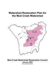
RESTORATION PLAN Glade Creek Stream Restoration Alleghany ...
RESTORATION PLAN Glade Creek Stream Restoration Alleghany ...
RESTORATION PLAN Glade Creek Stream Restoration Alleghany ...

You also want an ePaper? Increase the reach of your titles
YUMPU automatically turns print PDFs into web optimized ePapers that Google loves.
3.0 Project Site <strong>Stream</strong>s (existing conditions)3.1 Channel ClassificationAs part of the field reconnaissance, the Rosgen classification system (Rosgen, 1994) was used todetermine channel type at each field cross section on the basis of existing morphological features ofthe stream channel. Two stable, representative riffle cross sections were surveyed on <strong>Glade</strong> <strong>Creek</strong>.The measured channel dimensions for the representative cross sections generate a C4 classification;except for width/depth ratio at the cross sections were 9.1 and 11.1, just under the classificationminimum for a C channel, which is 12. A width/depth ration of less than 12 is characteristic of an Echannel. For this reason, the existing channel is classified as a C E 4 channel, in deference to the lowwidth/depth ratios at these representative riffles. However, in other sections of the <strong>Glade</strong> <strong>Creek</strong>channel, where downcutting and widening have occurred, decreasing the entrenchment ratio andincreasing the width/depth ratio, the channel classification is F4 or G4. The F4 and G4 classificationsare indicative of channel instability. Only one stable, representative cross section could be located onthe unnamed tributary. Based on the measurements taken in the field, the unnamed tributary also wasclassified as a C4.3.2 DischargeIn adjustable, alluvial, transport-limited rivers in temperate climates, flows of moderate frequency(e.g., the 1.5- to 2-year storm event) and magnitude perform most of the geomorphic work (Wolmanand Miller, 1960). This concept of the “dominant discharge” provides a statistical index for the flowthat corresponds with the peak volume of sediment transported. Dominant discharge is the maximumpossible product of the frequency of a flow occurrence and the amount of sediment transported bythat flow event. Channel morphology is ultimately a result of all flows above a sediment transportthreshold that do some geomorphic work. However, the dominant discharge is commonly used as asingle-value estimate for a flow that may be largely responsible for resulting geomorphic form.It is thought that, in many cases, the morphological feature of a bankfull elevation corresponds fairlywell to the flow stage of the dominant discharge. This has led to the concept of bankfull elevation asa tool in stream restoration design. However, the concept should be applied cautiously in streamrestoration design. It should be noted that as channel boundaries are more resistant or less adjustable(i.e., bedrock, hillslope constraints, or large bed material) or in more arid environments, the majorityof geomorphic work is more likely to be performed by larger and rarer flood events. For the purposesof this restoration plan, here the bankfull discharge is considered to be essentially equivalent to thedominant discharge, and serves a guiding value in many aspects of the restoration design.As mentioned in Section 3.1, the bankfull elevation was identified in the field by Biohabitatspersonnel at surveyed cross sections. The bankfull elevation at each cross section was derived fromall available indications including depositional features, changes in bank angle, vegetation, scourlines, and storm debris lines. Bankfull discharge was estimated by solving the Manning equation fordischarge given the bankfull elevation, local channel geometry, slope, and roughness. Channelroughness, represented by Manning's "n", was approximated using the standard references Chow(1959) and Barnes (1967) based on field observations of bed material, channel geometry, andadjacent riparian vegetation.For the purpose of comparison, a predicted bankfull discharge was also calculated for <strong>Glade</strong> <strong>Creek</strong>and the unnamed tributary using available North Carolina regression relationships for rural streams in