

Uilkraals Situation Assessment - Anchor Environmental
Uilkraals Situation Assessment - Anchor Environmental
Uilkraals Situation Assessment - Anchor Environmental

Create successful ePaper yourself
Turn your PDF publications into a flip-book with our unique Google optimized e-Paper software.
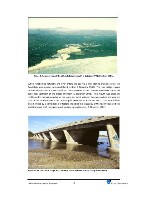
Figure 9. An aerial view of the <strong>Uilkraals</strong> Estuary mouth in October 1979 (altitude of 500m).When functioning naturally, the river enters the sea via a meandering channel across thefloodplain, which opens onto sand flats (Heydorn & Bickerton 1982). The road bridge crossesat the lower reaches of these sand flats. There are several river channels which flow across thesand flats upstream of the bridge (Heydorn & Bickerton 1982). The mouth was originallymobile and in the past could enter the sea at any point between the eastern dune and westernpart of the beach opposite the caravan park (Heydorn & Bickerton 1982). The mouth laterbecame fixed by a combination of factors, including the causeway of the road bridge and thestabilization of both the eastern and western dunes (Heydorn & Bickerton 1982).Figure 10. Picture of the bridge and causeway of the <strong>Uilkraals</strong> Estuary facing downstream.<strong>Uilkraals</strong> Estuary <strong>Situation</strong> <strong>Assessment</strong>19<strong>Anchor</strong> <strong>Environmental</strong>


