

A GIS Based Water Balance Study of Africa - Physical Land Resources
A GIS Based Water Balance Study of Africa - Physical Land Resources
A GIS Based Water Balance Study of Africa - Physical Land Resources

You also want an ePaper? Increase the reach of your titles
YUMPU automatically turns print PDFs into web optimized ePapers that Google loves.
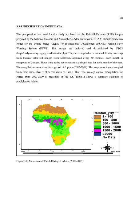
283.3.4 PRECIPITATION INPUT DATAThe precipitation data used for this study are based on the Rainfall Estimate (RFE) imagesprepared by the National Oceanic and Atmospheric Administration’s (NOAA) climate predictioncenter for the United States Agency for International Development (USAID) Faming earlyWarning System (FEWS). The images are archived and disseminated by USGS(http://earlywarning.usgs.gov/adds/index.php). They are compiled on a nominal 10 day time stepfrom thermal infra red images from Meteosat, acquired every 30 minutes. Each month iscomposed <strong>of</strong> 3 maps. These were added up to construct a single map for each month <strong>of</strong> the year.The compilations were done for a period <strong>of</strong> 3 years (2007-2009). The maps were then resampledfrom their initial 8km x 8km resolution to 1km x 1km. The average annual precipitation for<strong>Africa</strong> from 2007-2009 is presented in Fig 3.8. Table 2 shows a summary statistics <strong>of</strong>precipitation values.30° 30° 30° 10° 10° 30° 50° 70°10° 10°10° 10°(mm)Rainfall_yrly1 - 100100 - 500500 - 10001000 - 15001500 - 2000>2000No DataNWE3000 0 3000 6000 MilesSFigure 3.8: Mean annual Rainfall Map <strong>of</strong> <strong>Africa</strong> (2007-2009)30° 30° 10° 10° 30° 50° 70° 30°


