

A GIS Based Water Balance Study of Africa - Physical Land Resources
A GIS Based Water Balance Study of Africa - Physical Land Resources
A GIS Based Water Balance Study of Africa - Physical Land Resources

You also want an ePaper? Increase the reach of your titles
YUMPU automatically turns print PDFs into web optimized ePapers that Google loves.
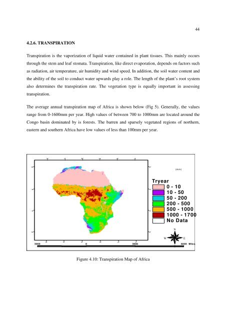
70°(mm)444.2.6. TRANSPIRATIONTranspiration is the vaporization <strong>of</strong> liquid water contained in plant tissues. This mainly occursthrough the stem and leaf stomata. Transpiration, like direct evaporation, depends on factors suchas radiation, air temperature, air humidity and wind speed. In addition, the soil water content andthe ability <strong>of</strong> the soil to conduct water upwards play a role. The length <strong>of</strong> the plant’s root systemalso determines the transpiration rate. The vegetation type is equally important in assessingtranspiration.The average annual transpiration map <strong>of</strong> <strong>Africa</strong> is shown below (Fig 5). Generally, the valuesrange from 0-1600mm per year. High values <strong>of</strong> between 700 to 1000mm are located around theCongo basin dominated by is forests. The barren and sparsely vegetated regions <strong>of</strong> northern,eastern and southern <strong>Africa</strong> have low values <strong>of</strong> less than 100mm per year.30° 30° 30° 10° 10° 30° 50°10° 10°10° 10°Tryear0 - 1010 - 5050 - 200200 - 500500 - 10001000 - 1700No DataNWE3000 0 3000 6000 MilesSFigure 4.10: Transpiration Map <strong>of</strong> <strong>Africa</strong>30° 30° 10° 10° 30° 50° 70° 30°


