

Church Road, Tadley - Basingstoke and Deane Borough Council
Church Road, Tadley - Basingstoke and Deane Borough Council
Church Road, Tadley - Basingstoke and Deane Borough Council

You also want an ePaper? Increase the reach of your titles
YUMPU automatically turns print PDFs into web optimized ePapers that Google loves.
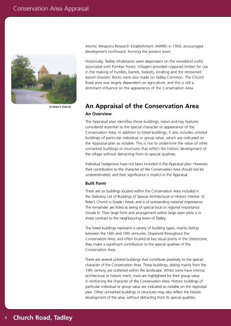
Conservation Area AppraisalAtomic Weapons Research Establishment (AWRE) in 1950, encourageddevelopment northward, forming the present town.Historically, <strong>Tadley</strong> inhabitants were dependant on the woodl<strong>and</strong> craftsassociated with Pamber Forest. Villagers provided coppiced timber for usein the making of hurdles, barrels, baskets, kindling <strong>and</strong> the renownedbesom brooms. Bricks were also made on <strong>Tadley</strong> Common. The <strong>Church</strong><strong>Road</strong> area was largely dependent on agriculture, <strong>and</strong> this is still adominant influence on the appearance of the Conservation Area.St Peter’s <strong>Church</strong>An Appraisal of the Conservation AreaAn OverviewThe Appraisal plan identifies those buildings, views <strong>and</strong> key featuresconsidered essential to the special character or appearance of theConservation Area. In addition to listed buildings, it also includes unlistedbuildings of particular individual or group value, which are indicated onthe Appraisal plan as notable. This is not to undermine the value of otherunmarked buildings or structures that reflect the historic development ofthe village without detracting from its special qualities.Individual hedgerows have not been included in the Appraisal plan. However,their contribution to the character of the Conservation Area should not beunderestimated, <strong>and</strong> their significance is implicit in the Appraisal.Built FormThere are six buildings located within the Conservation Area included inthe Statutory List of Buildings of Special Architectural or Historic Interest. StPeter’s <strong>Church</strong> is Grade I listed, <strong>and</strong> is of outst<strong>and</strong>ing national importance.The remainder are listed as being of special local or regional importance(Grade II). Their large form <strong>and</strong> arrangement within large open plots is insharp contrast to the neighbouring town of <strong>Tadley</strong>.The listed buildings represent a variety of building types, mainly datingbetween the 16th <strong>and</strong> 19th centuries. Dispersed throughout theConservation Area, <strong>and</strong> often located at key visual points in the streetscene,they make a significant contribution to the special qualities of theConservation Area.There are several unlisted buildings that contribute positively to the specialcharacter of the Conservation Area. These buildings, dating mainly from the19th century, are scattered within the l<strong>and</strong>scape. Whilst some have intrinsicarchitectural or historic merit, most are highlighted for their group valuein reinforcing the character of the Conservation Area. Historic buildings ofparticular individual or group value are indicated as notable on the Appraisalplan. Other unmarked buildings or structures may also reflect the historicdevelopment of the area, without detracting from its special qualities.4<strong>Church</strong> <strong>Road</strong>, <strong>Tadley</strong>


