

Banc y Celyn, Brecknockshire - Royal Commission on the Ancient ...
Banc y Celyn, Brecknockshire - Royal Commission on the Ancient ...
Banc y Celyn, Brecknockshire - Royal Commission on the Ancient ...
- No tags were found...

Create successful ePaper yourself
Turn your PDF publications into a flip-book with our unique Google optimized e-Paper software.
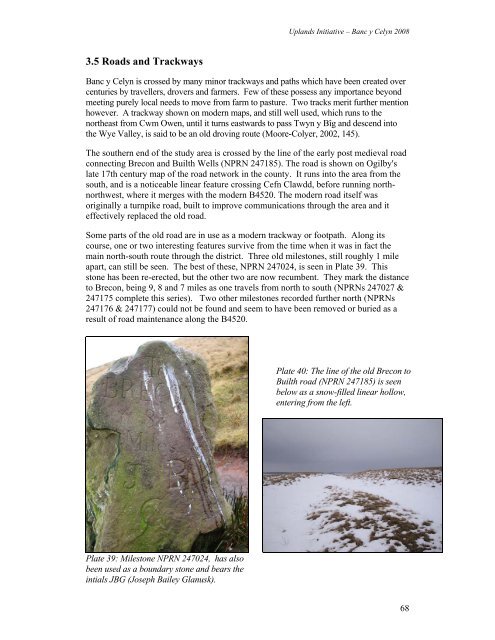
Uplands Initiative – <str<strong>on</strong>g>Banc</str<strong>on</strong>g> y <str<strong>on</strong>g>Celyn</str<strong>on</strong>g> 20083.5 Roads and Trackways<str<strong>on</strong>g>Banc</str<strong>on</strong>g> y <str<strong>on</strong>g>Celyn</str<strong>on</strong>g> is crossed by many minor trackways and paths which have been created overcenturies by travellers, drovers and farmers. Few of <strong>the</strong>se possess any importance bey<strong>on</strong>dmeeting purely local needs to move from farm to pasture. Two tracks merit fur<strong>the</strong>r menti<strong>on</strong>however. A trackway shown <strong>on</strong> modern maps, and still well used, which runs to <strong>the</strong>nor<strong>the</strong>ast from Cwm Owen, until it turns eastwards to pass Twyn y Bîg and descend into<strong>the</strong> Wye Valley, is said to be an old droving route (Moore-Colyer, 2002, 145).The sou<strong>the</strong>rn end of <strong>the</strong> study area is crossed by <strong>the</strong> line of <strong>the</strong> early post medieval roadc<strong>on</strong>necting Brec<strong>on</strong> and Builth Wells (NPRN 247185). The road is shown <strong>on</strong> Ogilby'slate 17th century map of <strong>the</strong> road network in <strong>the</strong> county. It runs into <strong>the</strong> area from <strong>the</strong>south, and is a noticeable linear feature crossing Cefn Clawdd, before running northnorthwest,where it merges with <strong>the</strong> modern B4520. The modern road itself wasoriginally a turnpike road, built to improve communicati<strong>on</strong>s through <strong>the</strong> area and iteffectively replaced <strong>the</strong> old road.Some parts of <strong>the</strong> old road are in use as a modern trackway or footpath. Al<strong>on</strong>g itscourse, <strong>on</strong>e or two interesting features survive from <strong>the</strong> time when it was in fact <strong>the</strong>main north-south route through <strong>the</strong> district. Three old milest<strong>on</strong>es, still roughly 1 mileapart, can still be seen. The best of <strong>the</strong>se, NPRN 247024, is seen in Plate 39. Thisst<strong>on</strong>e has been re-erected, but <strong>the</strong> o<strong>the</strong>r two are now recumbent. They mark <strong>the</strong> distanceto Brec<strong>on</strong>, being 9, 8 and 7 miles as <strong>on</strong>e travels from north to south (NPRNs 247027 &247175 complete this series). Two o<strong>the</strong>r milest<strong>on</strong>es recorded fur<strong>the</strong>r north (NPRNs247176 & 247177) could not be found and seem to have been removed or buried as aresult of road maintenance al<strong>on</strong>g <strong>the</strong> B4520.Plate 40: The line of <strong>the</strong> old Brec<strong>on</strong> toBuilth road (NPRN 247185) is seenbelow as a snow-filled linear hollow,entering from <strong>the</strong> left.Plate 39: Milest<strong>on</strong>e NPRN 247024, has alsobeen used as a boundary st<strong>on</strong>e and bears <strong>the</strong>intials JBG (Joseph Bailey Glanusk).68


![The Source of the Usk Walk [2012 PDF]](https://img.yumpu.com/49285699/1/190x245/the-source-of-the-usk-walk-2012-pdf.jpg?quality=85)


