Volcano geodesy and magma dynamics in Iceland - Acri-ST
Volcano geodesy and magma dynamics in Iceland - Acri-ST
Volcano geodesy and magma dynamics in Iceland - Acri-ST

Create successful ePaper yourself
Turn your PDF publications into a flip-book with our unique Google optimized e-Paper software.
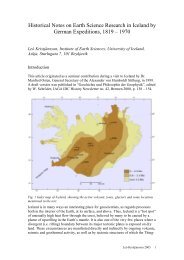
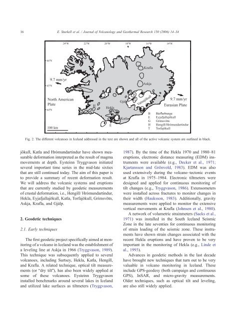
16E. Sturkell et al. / Journal of <strong>Volcano</strong>logy <strong>and</strong> Geothermal Research 150 (2006) 14–3424ºW 22ºW 20ºW 18ºW16ºW 14ºW66ºNKrafla65ºN9.7 mm/yrAskjaNorth AmericanPlate64ºN100 kmHHeklaTEGjálpKatlaBGVatnajökullBEGHT9.7 mm/yrEurasian PlateBár arbungaEyjafjallajökullGrímsvötnHengill/Hrómundart<strong>in</strong>durTorfajökullFig. 2. The different volcanoes <strong>in</strong> Icel<strong>and</strong> addressed <strong>in</strong> the text are shown <strong>and</strong> all of the active volcanic system are outl<strong>in</strong>ed <strong>in</strong> black.jökull, Katla <strong>and</strong> Hrómundart<strong>in</strong>dur have shown measurabledeformation <strong>in</strong>terpreted as the result of <strong>magma</strong>movements at depth. Eyste<strong>in</strong>n Tryggvason <strong>in</strong>itiatedseveral important time series <strong>in</strong> the mid-late sixtiesthat are still cont<strong>in</strong>ued today. The aim of this paper isto provide a summary of recent deformation result.We will address the volcanic systems <strong>and</strong> eruptionsthat are currently studied by geodetic measurementsof crustal deformation, i.e., Hengill/ Hrómundart<strong>in</strong>dur,Hekla, Eyjafjallajökull, Katla, Torfajökull, Grímsvötn,Askja, Krafla, <strong>and</strong> Gjálp.2. Geodetic techniques2.1. Early techniquesThe first geodetic project specifically aimed at monitor<strong>in</strong>gof a volcano <strong>in</strong> Icel<strong>and</strong> was the establishment ofa level<strong>in</strong>g l<strong>in</strong>e at Askja <strong>in</strong> 1966 (Tryggvason, 1989).This technique was subsequently applied to severalvolcanoes, <strong>in</strong>clud<strong>in</strong>g Surtsey, Hekla, Katla, Hengill,<strong>and</strong> Krafla. A related technique, optical tilt measurements(or bdry tiltQ), has also been widely applied atsome of these volcanoes. Eyste<strong>in</strong>n Tryggvason<strong>in</strong>stalled benchmarks around several lakes <strong>in</strong> Icel<strong>and</strong><strong>and</strong> utilized lake surfaces as tiltmeters (Tryggvason,1987). By the time of the Hekla 1970 <strong>and</strong> 1980–81eruptions, electronic distance measur<strong>in</strong>g (EDM) <strong>in</strong>strumentswere available (e.g., Decker et al., 1971;Kjartansson <strong>and</strong> Grönvold, 1983). EDM was alsoused extensively dur<strong>in</strong>g the volcano–tectonic eventsat Krafla <strong>in</strong> 1975–1984. Electronic tiltmeters weredesigned <strong>and</strong> applied for cont<strong>in</strong>uous monitor<strong>in</strong>g oftilt changes (e.g., Tryggvason, 1986). Extensometerswere <strong>in</strong>stalled across fractures to monitor changes <strong>in</strong>their width (Hauksson, 1983). Additionally, gravitymeasurements were applied to monitor the extensivevertical movements at Krafla (Johnsen et al., 1980).A network of volumetric stra<strong>in</strong>meters (Sacks et al.,1971) was <strong>in</strong>stalled <strong>in</strong> the South Icel<strong>and</strong> SeismicZone <strong>in</strong> the late seventies for cont<strong>in</strong>uous monitor<strong>in</strong>gof stra<strong>in</strong> load<strong>in</strong>g of the seismic zone. These <strong>in</strong>strumentshave shown stra<strong>in</strong> changes associated with therecent Hekla eruptions <strong>and</strong> have proven to be veryimportant <strong>in</strong> the monitor<strong>in</strong>g of Hekla (e.g., L<strong>in</strong>de etal., 1993).Advances <strong>in</strong> geodetic methods <strong>in</strong> the last decadehave brought new techniques that turn out to be veryvaluable <strong>in</strong> volcano monitor<strong>in</strong>g <strong>in</strong> Icel<strong>and</strong>. These<strong>in</strong>clude GPS-<strong>geodesy</strong> (both campaign <strong>and</strong> cont<strong>in</strong>uousGPS), InSAR, <strong>and</strong> micro-gravity measurements.Older techniques, such as optical tilt <strong>and</strong> level<strong>in</strong>g,are also still widely applied.