Windthrow Hazard Mapping using GIS, Canadian Forest Products ...
Windthrow Hazard Mapping using GIS, Canadian Forest Products ...
Windthrow Hazard Mapping using GIS, Canadian Forest Products ...

You also want an ePaper? Increase the reach of your titles
YUMPU automatically turns print PDFs into web optimized ePapers that Google loves.
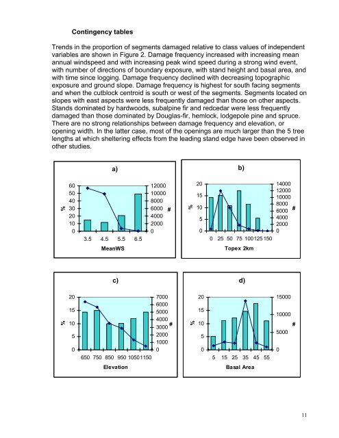
Contingency tablesTrends in the proportion of segments damaged relative to class values of independentvariables are shown in Figure 2. Damage frequency increased with increasing meanannual windspeed and with increasing peak wind speed during a strong wind event,with number of directions of boundary exposure, with stand height and basal area, andwith time since logging. Damage frequency declined with decreasing topographicexposure and ground slope. Damage frequency is highest for south facing segmentsand when the cutblock centroid is south or west of the segments. Segments located onslopes with east aspects were less frequently damaged than those on other aspects.Stands dominated by hardwoods, subalpine fir and redcedar were less frequentlydamaged than those dominated by Douglas-fir, hemlock, lodgepole pine and spruce.There are no strong relationships between damage frequency and elevation, oropening width. In the latter case, most of the openings are much larger than the 5 treelengths at which sheltering effects from the leading stand edge have been observed inother studies.a)b)%60504030201003.5 4.5 5.5 6.5120001000080006000400020000#%201510500 25 50 75 100125 15014000120001000080006000400020000#MeanWSTopex 2kmc)d)%2015105070006000500040003000200010000#%20151050150001000050000#650 750 850 950 105011505 15 25 35 45 55ElevationBasal Area11