Windthrow Hazard Mapping using GIS, Canadian Forest Products ...
Windthrow Hazard Mapping using GIS, Canadian Forest Products ...
Windthrow Hazard Mapping using GIS, Canadian Forest Products ...

Create successful ePaper yourself
Turn your PDF publications into a flip-book with our unique Google optimized e-Paper software.
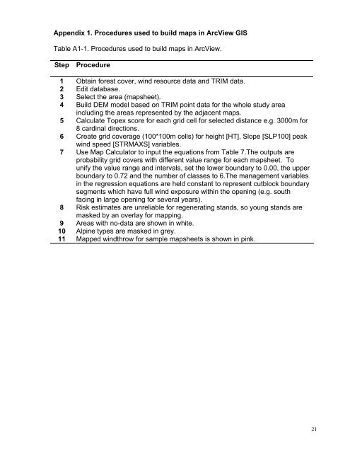
Appendix 1. Procedures used to build maps in ArcView <strong>GIS</strong>Table A1-1. Procedures used to build maps in ArcView.Step Procedure1 Obtain forest cover, wind resource data and TRIM data.2 Edit database.3 Select the area (mapsheet).4 Build DEM model based on TRIM point data for the whole study areaincluding the areas represented by the adjacent maps.5 Calculate Topex score for each grid cell for selected distance e.g. 3000m for8 cardinal directions.6 Create grid coverage (100*100m cells) for height [HT], Slope [SLP100] peakwind speed [STRMAXS] variables.7 Use Map Calculator to input the equations from Table 7.The outputs areprobability grid covers with different value range for each mapsheet. Tounify the value range and intervals, set the lower boundary to 0.00, the upperboundary to 0.72 and the number of classes to 6.The management variablesin the regression equations are held constant to represent cutblock boundarysegments which have full wind exposure within the opening (e.g. southfacing in large opening for several years).8 Risk estimates are unreliable for regenerating stands, so young stands aremasked by an overlay for mapping.9 Areas with no-data are shown in white.10 Alpine types are masked in grey.11 Mapped windthrow for sample mapsheets is shown in pink.21