Windthrow Hazard Mapping using GIS, Canadian Forest Products ...
Windthrow Hazard Mapping using GIS, Canadian Forest Products ...
Windthrow Hazard Mapping using GIS, Canadian Forest Products ...

Create successful ePaper yourself
Turn your PDF publications into a flip-book with our unique Google optimized e-Paper software.
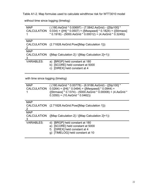
Table A1-2. Map formulas used to calculate windthrow risk for WTT3010 modelwithout time since logging (timelog)MAPCALCULATION1( (180.AsGrid * 0.00697) - (7.5842.AsGrid) - ([Slp100] *0.034) + ([Ht] * 0.0507) + ([Mwspeed] * 0.1824) + ([Strmaxs]* 0.1918) - (5000.AsGrid * 0.00012) + (4.AsGrid * 0.3249))MAPCALCULATION (2.71828.AsGrid.Pow([Map Calculation 1]))2MAPCALCULATION ([Map Calculation 2] / ([Map Calculation 2]+1))3VARIABLES: a) [BRGP] held constant at 180b) [SCORE] held constant at 5000c) [DIREX] held constant at 4with time since logging (timelog)MAPCALCULATION1( (180.AsGrid * 0.00778) - (6.9186.AsGrid) - ([Slp100] *0.0264) + ([Ht] * 0.0494) + ([Mwspeed] * 0.0944) +([Strmaxs] * 0.1374) - (5000.AsGrid * 0.00008) + (4.AsGrid *0.3350) + (10.AsGrid * 0.0462))MAPCALCULATION (2.71828.AsGrid.Pow([Map Calculation 1]))2MAPCALCULATION ([Map Calculation 2] / ([Map Calculation 2]+1))3VARIABLES: d) [BRGP] held constant at 180e) [SCORE] held constant at 5000f) [DIREX] held constant at 4g) [TIMELOG] held constant at 1022