Project StarshineProject Starshine engaged approximately120,000 students in more than 4,000schools in 43 countries.<strong>NASA</strong> deployed reflective sphericalstudent satellites from two separateshuttle missions—STS-96 (1999) <strong>and</strong>STS-108 (2001). <strong>NASA</strong> had flown athird satellite on an expendable launchvehicle mission, <strong>and</strong> a fourth satellitewas manifested on a shuttle mission butlater cancelled following the Columbiaaccident (STS-107 [2003]). A coalitionof volunteer organizations <strong>and</strong>individuals in the United States <strong>and</strong>Canada built the satellites. Each satellitewas covered by approximately 1,000small front-surface aluminum mirrorsthat were machined by technologystudents in Utah <strong>and</strong> polished by tensof thous<strong>and</strong>s of students in schools <strong>and</strong>other participating organizations aroundthe world. During the orbital lifetimeof the satellites, faint sunlight flashesfrom their student-polished mirrorswere visible to the naked eye duringcertain morning <strong>and</strong> evening twilightperiods. The student observersStudents in the Young Astronauts/AstronomyClub at Weber Middle School in Port Washington,New York, proudly display a set of mirrorsdestined for Starshine.measured the satellites’ right ascension<strong>and</strong> declination by reference to knownstars, <strong>and</strong> they recorded the precisetiming of their observations throughthe use of stopwatches synchronizedwith Internet time signals. They usedglobal positioning satellite receivers orUS Geological Survey 7.5-minutequadrangle maps, or their equivalents inother countries, to measure the latitude,longitude, <strong>and</strong> altitude of theirobserving sites. They posted theirobservations <strong>and</strong> station locations onthe Starshine Web site.Launching Starshine satellite from Endeavour’s payload bay during STS-108 (2001).© Gilbert Moore.Reproduced with permission. All rights reserved.As an example of Project Starshine,children in the Young Astronauts/Astronomy Club at Weber MiddleSchool in Port Washington, New York,contributed to the project.“The club members arrived at schoolat 7:30 a.m. every day to make surethe project would be completed on time.They worked diligently <strong>and</strong> followedinstructions to the letter,” said theirscience teacher, Cheryl Dodes.Earth Knowledge Acquired byMiddle School StudentsHow does one inspire school students topursue science <strong>and</strong> engineering? Imaginecreating an opportunity for students toparticipate in space operations duringreal Space Shuttle flights.The brainchild of Dr. Sally Ride—first American woman in space—the Earth Knowledge Acquired byMiddle School Students (EarthKAM)education program, sponsored by<strong>NASA</strong>, gives students “h<strong>and</strong>s-on”experience in space operations. Duringthe Space Shuttle Program, <strong>NASA</strong>’sEarthKAM was the next best thing tobeing on board for junior scientists.The idea is as simple as it is elegant:by installing a <strong>NASA</strong> camera on boarda spacecraft, middle school studentsacross the United States <strong>and</strong> abroadhad front-row seats on a space mission.They used images to study Earthscience <strong>and</strong> other science disciplinesby examining river deltas, deforestation,<strong>and</strong> agriculture. The hardware consistedof an electronic still camera <strong>and</strong> alaptop that was set up by an astronaut<strong>and</strong> then operated remotely from theground with imaging requests comingdirectly from the students.While this h<strong>and</strong>s-on, science-immersivelearning was cool for kids, the high-techappeal was based on proper science474<strong>Social</strong>, <strong>Cultural</strong>, <strong>and</strong> <strong>Educational</strong> <strong>Legacies</strong>
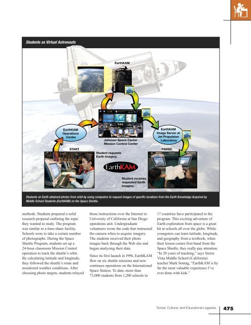
Students as Virtual AstronautsEarthKAMEarthKAMOperationsCenterSTARTJohnson Space CenterMission Control CenterStudent requestsEarth imagery.EarthKAMImage Server atJet PropulsionLaboratoryFINISHStudent receivesrequested Earthimagery.Students on Earth obtained photos from orbit by using computers to request images of specific locations from the Earth Knowledge Acquired byMiddle School Students (EarthKAM) on the Space Shuttle.methods. Students prepared a solidresearch proposal outlining the topicthey wanted to study. The programwas similar to a time-share facility.Schools were to take a certain numberof photographs. During the SpaceShuttle Program, students set up a24-hour classroom Mission Controloperation to track the shuttle’s orbit.By calculating latitude <strong>and</strong> longitude,they followed the shuttle’s route <strong>and</strong>monitored weather conditions. Afterchoosing photo targets, students relayedthose instructions over the Internet toUniversity of California at San Diegooperations unit. Undergraduatevolunteers wrote the code that instructedthe camera when to acquire imagery.The students received their photoimages back through the Web site <strong>and</strong>began analyzing their data.Since its first launch in 1996, EarthKAMflew on six shuttle missions <strong>and</strong> nowcontinues operations on the InternationalSpace Station. To date, more than73,000 students from 1,200 schools in17 countries have participated in theprogram. This exciting adventure ofEarth exploration from space is a greathit at schools all over the globe. Whileyoungsters can learn latitude, longitude,<strong>and</strong> geography from a textbook, whentheir lesson comes first-h<strong>and</strong> from theSpace Shuttle, they really pay attention.“In 20 years of teaching,” says SierraVista Middle School (California)teacher Mark Sontag, “EarthKAM is byfar the most valuable experience I’veever done with kids.”<strong>Social</strong>, <strong>Cultural</strong>, <strong>and</strong> <strong>Educational</strong> <strong>Legacies</strong>475