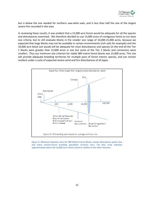
ut is below the size needed for northern saw-whet owls, and is less than half the size <strong>of</strong> the largestsevere fire recorded in the area.In reviewing these results, it was evident that a 15,000 acre forest would be adequate for all the speciesand disturbances examined. We therefore decided to use 15,000 acres <strong>of</strong> contiguous forest as our basesize criteria, but to still evaluate blocks in the smaller size range <strong>of</strong> 10,000-15,000 acres, because weexpected that large blocks may not be available in certain environments (rich soils for example) and the10,000 acre block size would still be adequate for most disturbances and species (in the end all the Tier1 blocks were greater than 15,000 acres in size but some <strong>of</strong> the Tier 2 blocks and connectors weresmaller). Thus our minimum size criterion for viable SBR matrix forest blocks was 15,000 acres. This sizewill provide adequate breeding territories for multiple pairs <strong>of</strong> forest interior species, and can remainresilient under a suite <strong>of</strong> expected severe wind and fire disturbances <strong>of</strong> all types.Figure 3. Minimum Dynamic Area for SBR <strong>Matrix</strong> Forest Blocks, known disturbance patch sizesand select interior-forest breeding specialists’ territory sizes. The blue circle indicatesapproximately where the 15,000 acre criteria stand in relation to the other features.12
CLASSIFYING THE MATRIX FOREST BLOCKS<strong>An</strong> understanding <strong>of</strong> patterns <strong>of</strong> environmental variation and biological diversity is fundamental toconservation planning at any scale—regional, landscape level, or local. Moreover, maintaining forestbiodiversity through a forest reserve network is a trade<strong>of</strong>f between distributing risk over many reservesrepresenting the full spectrum <strong>of</strong> environmental settings (the goal <strong>of</strong> this analysis stage) and minimizingthe probability <strong>of</strong> loss in each individual reserve (the goal <strong>of</strong> the size criteria analysis stage).In order to identify a representative network <strong>of</strong> matrix forest blocks, a dataset was developed to assessthe geophysical character <strong>of</strong> the landscape, which can also be used to approximate the distribution andcomposition <strong>of</strong> many community assemblages across those landscapes. The close relationship <strong>of</strong> thephysical environment to ecological process and biotic distributions underpins the ecological sciences,and given the changing climate and associated changing species distributions, geophysical diversity maybe an appropriate target for conservation planning (<strong>An</strong>derson and Ferree 2010) Research has repeatedlydemonstrated especially strong links between ecosystem pattern and processes, climate, bedrock, soils,and topography.To quantify the physical diversity <strong>of</strong> the <strong>Southern</strong> <strong>Blue</strong> <strong>Ridge</strong>, we developed individual 30m cell GISdatasets <strong>of</strong> elevation, geology, and landforms, and integrated them into a single unit called theEcological Land Unit (ELU). Each ELU code represents a specific landform (e.g., cove), composed <strong>of</strong> aspecific bedrock type (e.g., calcareous), within a specific elevation zone (e.g., low elevation). The ELUdataset describes only the physical information, but it can be combined with land use or land covermaps to approximate vegetation types. We present a brief description <strong>of</strong> each <strong>of</strong> the ELU dataset layersbelow.ELEVATIONElevation is a strong predictor <strong>of</strong> the distribution <strong>of</strong> forest communities. Temperature, precipitation,and exposure commonly vary with changing altitude, as does the dominant vegetation type. Red sprucebegins to occur within northern hardwood forests at around 1,405m (4,500ft) and becomes moredominant with increasing elevation. Fraser fir species abundance increases above 1,720m (5,500ft) andcan occur in pure stands over 1,875m (6,000ft). Hemlock-dominated forests, along with white pine andhardwood mixed habitats, occur at middle elevations and <strong>of</strong>ten in small stands along north-facing slopesat elevations between about 762-1,220m (2,500-4,000ft). Variations <strong>of</strong> cove forest can be foundthroughout the <strong>Southern</strong> Appalachians at elevations from 305 to 1,372m (1,000-4,500ft). Appalachianoak forests composed <strong>of</strong> northern red, chestnut, white, and black oaks, in combination with many otherspecies (especially pignut and mockernut hickory and red maple) typically occur at elevations from 250mto 1,280m (820-4,200ft) elevations (Stephenson et al. 1993, Hunter et al. 1999).We used the following elevation cut<strong>of</strong>fs to map distinct elevation zones:Very HighHighMedium HighMedium LowLow5,500ft+4,200-5,500ft3,500-4,200ft2,300-3,500ft2,300ft or less13