

Southern Blue Ridge: An Analysis of Matrix Forests - Conservation ...
Southern Blue Ridge: An Analysis of Matrix Forests - Conservation ...
Southern Blue Ridge: An Analysis of Matrix Forests - Conservation ...

Create successful ePaper yourself
Turn your PDF publications into a flip-book with our unique Google optimized e-Paper software.
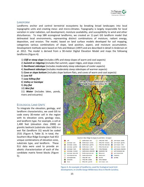
LANDFORMLandforms anchor and control terrestrial ecosystems by breaking broad landscapes into localtopographic units and creating meso- and micro-climates. Topography is largely responsible for localvariation in solar radiation, soil development, moisture availability, and susceptibility to wind and otherdisturbances. To map SBR ecoregional landforms, we created an 11-part GIS landform model thatdelineated local environments, representing distinct combinations <strong>of</strong> moisture, radiant energy,deposition, and erosion. The model, based on land surface models developed for soil mapping,categorizes various combinations <strong>of</strong> slope, land position, aspect, and moisture accumulation.Development methods were based on Fels and Matson (1997) and are described in detail in <strong>An</strong>derson etal. 2012. The model is derived from a 30-meter Digital Elevation Model and maps the followinglandforms (Figure 4):1) Cliff or steep slope (includes cliffs and steep slopes <strong>of</strong> warm and cool aspects)2) Summit or ridgetop (includes flat summit, upper ridges, and slope crests)3) Northeast sideslope (includes moderately steep sideslopes <strong>of</strong> cooler aspects)4) Southwest sideslope (includes moderately steep sideslopes <strong>of</strong> warmer aspects)5) Cove or slope bottom (includes slope bottom flats, and coves <strong>of</strong> warm and cool aspects)6) Low hill7) Low hilltop flat8) Valley or toeslope9) Dry flat10) Wet flat11) Water (includes lakes, ponds,rivers and estuaries)ECOLOGICAL LAND UNITSTo integrate the elevation, geology, andlandform characteristics, we used GIS tocode every 30-meter cell in the regionwith its elevation zone, geology class,and landform type. For example, a cell at1,400 feet (elevation class 2000) ongranitic bedrock (substrate class 500) in awet flat (landform 31) would be coded2531 (Figure 4, Table 3). In total, the<strong>Southern</strong> <strong>Blue</strong> <strong>Ridge</strong> Ecoregion had 453unique combinations <strong>of</strong> elevation zone,substrate type, and landform. TheseELU data were used to provide anabiotic characterization <strong>of</strong> each <strong>of</strong> thecandidate matrix forest blocks (Figure5).Figure 4. <strong>An</strong> example <strong>of</strong> landforms, used for Ecological Land Unitdevelopment, in Linville Gorge Wilderness Area in North Carolina.15


