

Southern Blue Ridge: An Analysis of Matrix Forests - Conservation ...
Southern Blue Ridge: An Analysis of Matrix Forests - Conservation ...
Southern Blue Ridge: An Analysis of Matrix Forests - Conservation ...

Create successful ePaper yourself
Turn your PDF publications into a flip-book with our unique Google optimized e-Paper software.
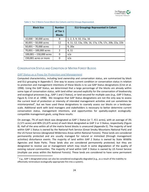
Table 5. Tier 2 <strong>Matrix</strong> Forest Block Size Cohorts and ELU Groups Represented.Block SizeNumber<strong>of</strong> Tier 1Blocks10,000 – 30,000 acres 8 1, 2, 3, 9, 10, 15a, 16ELU Groupings Represented in Cohort30,001 – 50,000 acres 12 4, 11, 12, 13a, 15b, 16, 17a, 17b, 17c, 20b, 22a, 22b50,001 – 70,000 acres 2 9, 20a70,001 – 100,000 acres 2 4, 11100,001 – 150,000 acres 0 n/a150,001 acres or more 0 n/aCONSERVATION STATUS AND CONDITION OF MATRIX FOREST BLOCKSGAP Status as a Proxy for Protection and ManagementComputed characteristics, including land ownership and conservation status, are summarized by blockand ELU grouping in Appendix E. One way to assess current condition or conservation status in relationto protection and management intentions <strong>of</strong> these blocks is to use GAP Status designations (Crist et al.1998). Using the GAP Status, we determined that a large percentage <strong>of</strong> the blocks are already withinsome type <strong>of</strong> conservation status, with land either secured explicitly for the conservation <strong>of</strong> biodiversityand ecological processes (e.g., GAP 1 and 2 Status), or land secured for multiple uses (e.g., GAP 3 Status,Figure 8, Crist et al. 1998). We recognize that GAP Status designations are not the only way to assessthe current level <strong>of</strong> protection or intensity <strong>of</strong> intended management activities and can sometimes bemisinterpreted 3 , but we have used these designations to coarsely assess our blocks on a landscapescale.Additional work with land managers and stakeholders is necessary to better determine currentconservation status, management intentions, and opportunities for spatially-explicit ecologicallycompatiblemanagement goals, using these results.On average, 7% <strong>of</strong> each block was designated as GAP 1 Status (or 7, 411 acres), with an average <strong>of</strong> 3%(1,571 acres) and 40% (21,675 acres) <strong>of</strong> each block designated as GAP 2 or 3 Status, respectively (Figure8). Half <strong>of</strong> the area within all <strong>of</strong> the matrix forest blocks is unsecured (Appendix E). The majority <strong>of</strong> landwithin GAP 1 Status is owned by the National Park Service (Great Smoky Mountains National Park) andthe US Forest Service (designated Wilderness Areas within National <strong>Forests</strong>). These lands are consideredpermanently protected and are usually managed for natural or mimicked (through managementactivities) disturbance events. The majority <strong>of</strong> land within GAP 2 Status is owned by State WildlifeAgencies and State Parks. These lands also are considered permanently protected, but they aredesignated to receive use or management which may result in some degradation <strong>of</strong> the quality <strong>of</strong>existing natural communities. The majority <strong>of</strong> land within GAP 3 Status is owned by US Forest Service(multiple use areas within the National <strong>Forests</strong>). These lands are considered to have some permanent3 E.g., GAP 1 designated areas can also be considered ecologically-degraded (e.g., as a result <strong>of</strong> the inability toeffectively reintroduce ecologically-appropriate fire into a system).24


