

Summary - City of Gosnells
Summary - City of Gosnells
Summary - City of Gosnells

Create successful ePaper yourself
Turn your PDF publications into a flip-book with our unique Google optimized e-Paper software.
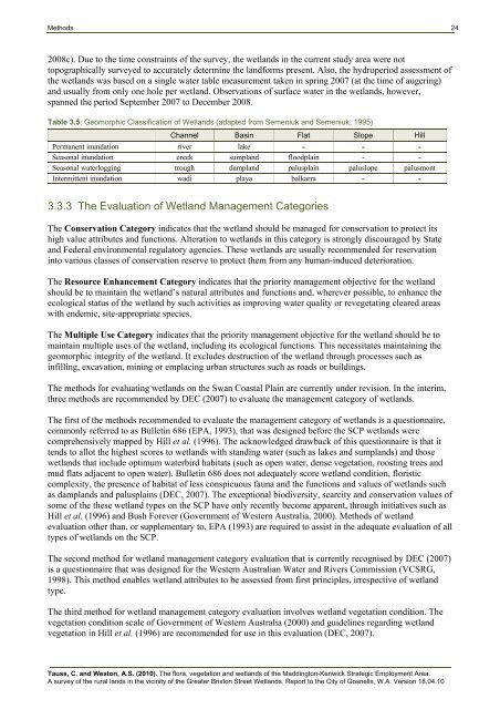
Methods 242008c). Due to the time constraints <strong>of</strong> the survey, the wetlands in the current study area were nottopographically surveyed to accurately determine the landforms present. Also, the hydroperiod assessment <strong>of</strong>the wetlands was based on a single water table measurement taken in spring 2007 (at the time <strong>of</strong> augering)and usually from only one hole per wetland. Observations <strong>of</strong> surface water in the wetlands, however,spanned the period September 2007 to December 2008.Table 3.5: Geomorphic Classification <strong>of</strong> Wetlands (adapted from Semeniuk and Semeniuk, 1995)Channel Basin Flat Slope HillPermanent inundation river lake - - -Seasonal inundation creek sumpland floodplain - -Seasonal waterlogging trough dampland palusplain paluslope palusmontIntermittent inundation wadi playa balkarra - -3.3.3 The Evaluation <strong>of</strong> Wetland Management CategoriesThe Conservation Category indicates that the wetland should be managed for conservation to protect itshigh value attributes and functions. Alteration to wetlands in this category is strongly discouraged by Stateand Federal environmental regulatory agencies. These wetlands are usually recommended for reservationinto various classes <strong>of</strong> conservation reserve to protect them from any human-induced deterioration.The Resource Enhancement Category indicates that the priority management objective for the wetlandshould be to maintain the wetland’s natural attributes and functions and, wherever possible, to enhance theecological status <strong>of</strong> the wetland by such activities as improving water quality or revegetating cleared areaswith endemic, site-appropriate species.The Multiple Use Category indicates that the priority management objective for the wetland should be tomaintain multiple uses <strong>of</strong> the wetland, including its ecological functions. This necessitates maintaining thegeomorphic integrity <strong>of</strong> the wetland. It excludes destruction <strong>of</strong> the wetland through processes such asinfilling, excavation, mining or emplacing urban structures such as roads or buildings.The methods for evaluating wetlands on the Swan Coastal Plain are currently under revision. In the interim,three methods are recommended by DEC (2007) to evaluate the management category <strong>of</strong> wetlands.The first <strong>of</strong> the methods recommended to evaluate the management category <strong>of</strong> wetlands is a questionnaire,commonly referred to as Bulletin 686 (EPA, 1993), that was designed before the SCP wetlands werecomprehensively mapped by Hill et al. (1996). The acknowledged drawback <strong>of</strong> this questionnaire is that ittends to allot the highest scores to wetlands with standing water (such as lakes and sumplands) and thosewetlands that include optimum waterbird habitats (such as open water, dense vegetation, roosting trees andmud flats adjacent to open water). Bulletin 686 does not adequately score wetland condition, floristiccomplexity, the presence <strong>of</strong> habitat <strong>of</strong> less conspicuous fauna and the functions and values <strong>of</strong> wetlands suchas damplands and palusplains (DEC, 2007). The exceptional biodiversity, scarcity and conservation values <strong>of</strong>some <strong>of</strong> the these wetland types on the SCP have only recently become apparent, through initiatives such asHill et al. (1996) and Bush Forever (Government <strong>of</strong> Western Australia, 2000). Methods <strong>of</strong> wetlandevaluation other than, or supplementary to, EPA (1993) are required to assist in the adequate evaluation <strong>of</strong> alltypes <strong>of</strong> wetlands on the SCP.The second method for wetland management category evaluation that is currently recognised by DEC (2007)is a questionnaire that was designed for the Western Australian Water and Rivers Commission (VCSRG,1998). This method enables wetland attributes to be assessed from first principles, irrespective <strong>of</strong> wetlandtype.The third method for wetland management category evaluation involves wetland vegetation condition. Thevegetation condition scale <strong>of</strong> Government <strong>of</strong> Western Australia (2000) and guidelines regarding wetlandvegetation in Hill et al. (1996) are recommended for use in this evaluation (DEC, 2007).Tauss, C. and Weston, A.S. (2010). The flora, vegetation and wetlands <strong>of</strong> the Maddington-Kenwick Strategic Employment Area.A survey <strong>of</strong> the rural lands in the vicinity <strong>of</strong> the Greater Brixton Street Wetlands. Report to the <strong>City</strong> <strong>of</strong> <strong>Gosnells</strong>, W.A. Version 18.04.10


