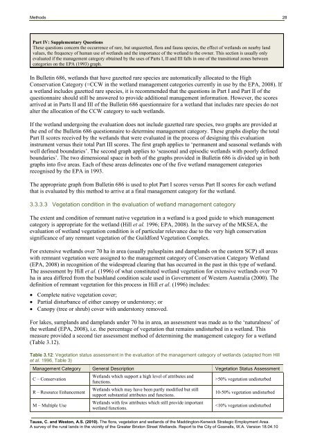
Methods 27Table 3.10: Management categories <strong>of</strong> wetlands from EPA Bulletin 686 as updated in Hill et al. (1996)Management category General description Management objectiveH – High Conservation(incorporates EPA Bulletin686 categories H and C)R – Resource Enhancement(incorporates EPA Bulletin686 categories O and R)M – Multiple Use(aligned with EPA Bulletin686 category M)Wetlands which support ahigh level <strong>of</strong> attributes andfunctions.Wetlands which may havebeen partly modified butstill support substantialattributes and functions.Wetlands with fewattributes which stillprovide important wetlandfunctions.To preserve wetland attributes and functions through reservationin national parks, crown reserves and state owned land andprotection under Environmental Protection Policies.To restore wetlands through maintenance and enhancement <strong>of</strong>wetland attributes and functions by protection in crown reservesand state or local government owned land and by EnvironmentalProtection Policies or in private property by sustainablemanagement.Use, development and management should be considered in thecontext <strong>of</strong> water, town (land use) and environmental planningthrough land care.In EPA Bulletin 686, wetland basins are evaluated as isolated units (either with well-defined boundaries orwith diffuse boundaries). It is well-acknowledged that palusplains and damplands are not adequatelyevaluated by the use <strong>of</strong> Bulletin 686 (DEC, 2007) and that other methods, such as VSCRG (1998) andvegetation condition assessment, are more relevant to the assessment <strong>of</strong> these wetlands.Bulletin 686 consists <strong>of</strong> a questionnaire that includes several parts, as briefly listed below (Table 3.11).Table 3.11: Bulletin 686 Questionnaire for Wetland Management Category EvaluationPart I: Presence <strong>of</strong> Rare SpeciesIf the wetland includes gazetted rare flora or fauna species then the wetland is automatically allocated to CCW.Part II Natural AttributesPart IIA: For permanent and seasonal wetlands with well defined boundariesi. Environmental geology classification: wetlands in the Quindalup Dunes or in river/estuary floodplain receive the highestscore.ii. Adjacent wetlands. Wetlands that have no other wetlands within a 2 km radius <strong>of</strong> them receive the highest score.iii. Habitat diversity. If the composition and structure <strong>of</strong> the vegetation <strong>of</strong> the wetland under evaluation is significantly differentto that found at other nearby wetlands, the wetland receives the highest score.iv. Drought refuge. Wetlands that are major drought refuges for birds receive the highest score.v. Area <strong>of</strong> wetland. Wetlands greater the 100 ha in area receive the highest score.vi. Habitat type. Habitat types scored in this question include vegetation and landforms typical <strong>of</strong> lakes and sumplands such asfringing rushes and sedges, extensive in lake beds <strong>of</strong> rushes and sedges, large paperbark trees, islands, flooded grassland,permanent or seasonal open water, low thickets and samphires. Waterlogged areas are not considered in the scoring.vii. Emergent vegetation. Wetlands with a moderate cover (40-60%) <strong>of</strong> emergent vegetation receive the highest score comparedto very high or very low cover <strong>of</strong> vegetation as both open water and vegetation are considered desirable for waterbirds.viii. Adverse water quality. Oil slicks, algal blooms or botulism that have been observed or reported from the wetland in the lasttwo years lower the score received by the wetland.ix. Drainage. This deals with drains into and/or out <strong>of</strong> the wetland that can alter water levels or water quality. Wetlands withfewer drains entering the wetland receive the highest score as this lowers the chances <strong>of</strong> nutrient enrichment and artificialelevation <strong>of</strong> water levels. Wetlands with outlet drains constructed to maintain water levels receive the highest score, whilstoutlet drains constructed to dry out the wetland receive the lowest score.x. Adjacent nutrient scores. Wetlands with more than one nutrient source lower the score received by the wetland.xi. Area <strong>of</strong> wetland modified. Wetlands with 0-10% <strong>of</strong> area modified receive the highest score.xii. Reserve Area. The ratio <strong>of</strong> the area <strong>of</strong> wetland to the area <strong>of</strong> reserve around the wetland is considered in this question. Thelowest wetland to reserve ratio (100 ha in area receive the highest score inthe latter question.Part III: Human Use QuestionnaireWetlands that have attributes such as aesthetic values, historical and archaeological features, reserve status and community groupinvolvement and uses such as passive and active recreation, agriculture, mining or water supply receive the highest scores.Tauss, C. and Weston, A.S. (2010). The flora, vegetation and wetlands <strong>of</strong> the Maddington-Kenwick Strategic Employment Area.A survey <strong>of</strong> the rural lands in the vicinity <strong>of</strong> the Greater Brixton Street Wetlands. Report to the <strong>City</strong> <strong>of</strong> <strong>Gosnells</strong>, W.A. Version 18.04.10
Methods 28Part IV: Supplementary QuestionsThese questions concern the occurrence <strong>of</strong> rare, but ungazetted, flora and fauna species, the effect <strong>of</strong> wetlands on nearby landvalues, the frequency <strong>of</strong> human use <strong>of</strong> wetlands and the importance <strong>of</strong> the wetland to the owner. This section is usually onlyevaluated if the management category obtained by the uses <strong>of</strong> Parts I, II and III falls in one <strong>of</strong> the transitional zones betweencategories on the EPA (1993) graph.In Bulletin 686, wetlands that have gazetted rare species are automatically allocated to the HighConservation Category (=CCW in the wetland management categories currently in use by the EPA, 2008). Ifa wetland includes gazetted rare species, it is recommended that the questions in Part I and Part II <strong>of</strong> thequestionnaire should still be answered to provide additional management information. However, the scoresarrived at in Parts II and III <strong>of</strong> the Bulletin 686 questionnaire for a wetland that includes rare species do notalter the allocation <strong>of</strong> the CCW category to such wetlands.If the wetland undergoing the evaluation does not include gazetted rare species, two graphs are provided atthe end <strong>of</strong> the Bulletin 686 questionnaire to determine management category. These graphs display the totalPart II scores received by the wetlands that were evaluated in the process <strong>of</strong> designing this evaluationinstrument versus their total Part III scores. The first graph applies to ‘permanent and seasonal wetlands withwell defined boundaries’. The second graph applies to ‘seasonal and episodic wetlands with poorly definedboundaries’. The two dimensional space in both <strong>of</strong> the graphs provided in Bulletin 686 is divided up in bothgraphs into five areas. Each <strong>of</strong> these areas delineates one <strong>of</strong> the five wetland management categoriesrecognised by the EPA in 1993.The appropriate graph from Bulletin 686 is used to plot Part I scores versus Part II scores for each wetlandthat is evaluated by this method to arrive at a final management category for the wetland.3.3.3.3 Vegetation condition in the evaluation <strong>of</strong> wetland management categoryThe extent and condition <strong>of</strong> remnant native vegetation in a wetland is a good guide to which managementcategory is appropriate for the wetland (Hill et al. 1996; EPA, 2008). In the survey <strong>of</strong> the MKSEA, theevaluation <strong>of</strong> wetland vegetation condition is <strong>of</strong> particular relevance due to the very high conservationsignificance <strong>of</strong> any remnant vegetation <strong>of</strong> the Guildford Vegetation Complex.For extensive wetlands over 70 ha in area (usually palusplains and damplands on the eastern SCP) all areaswith remnant vegetation were assigned to the management category <strong>of</strong> Conservation Category Wetland(EPA, 2008) in recognition <strong>of</strong> the widespread clearing that has occurred in the past in this type <strong>of</strong> wetland.The assessment by Hill et al. (1996) <strong>of</strong> what constituted wetland vegetation for extensive wetlands over 70ha in area differed from the bushland condition scale used in Government <strong>of</strong> Western Australia (2000). Thedefinition <strong>of</strong> remnant vegetation for this process in Hill et al. (1996) includes:• Complete native vegetation cover;• Partial disturbance <strong>of</strong> either canopy or understorey; or• Canopy (tree or shrub) cover with understorey removed.For lakes, sumplands and damplands under 70 ha in area, an assessment was made as to the ‘naturalness’ <strong>of</strong>the wetland (EPA, 2008), i.e. the percentage <strong>of</strong> vegetation that remains undisturbed in a wetland. Thismeasure provided a second tier assessment method <strong>of</strong> determining the management category for a wetland(Table 3.12).Table 3.12: Vegetation status assessment in the evaluation <strong>of</strong> the management category <strong>of</strong> wetlands (adapted from Hillet al. 1996, Table 3)Management Category General Description Vegetation Status AssessmentC – ConservationR – Resource EnhancementM – Multiple UseWetlands which support a high level <strong>of</strong> attributes andfunctions.Wetlands which may have been partly modified but stillsupport substantial attributes and functions.Wetlands with few attributes which still provide importantwetland functions.>50% vegetation undisturbed10-50% vegetation undisturbed


