

Summary - City of Gosnells
Summary - City of Gosnells
Summary - City of Gosnells

You also want an ePaper? Increase the reach of your titles
YUMPU automatically turns print PDFs into web optimized ePapers that Google loves.
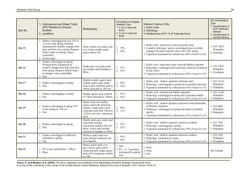
Wetlands Field Survey 86Site No.1. Hydroperiod and Water Table(WT) Relative to GroundSurface2. LandformStratigraphyFacultative & ObligateWetland Taxa1. F (as % total siteflora)2. O (as % total siteflora)Wetland Criteria <strong>of</strong> Site1. Hydric soils2. Hydrology3. Wetland taxa (O+F % <strong>of</strong> Total site flora)UFI and WetlandType1. Classification inSCP WetlandsDataset2. Classification inCurrent SurveySite 151. Surface waterlogged all year, WT to-25 cm in late spring. Wetlandmaintained by rainfall, seepage fromdune and flow from spring. Requiresfurther study to manage valuessustainably.2. Gentle slope.1. Surface waterlogged in spring.Wetland partly maintained byrainfall, seepage from dune and flowfrom spring. Requires further studyto manage values sustainably.2. Flat.30cm <strong>of</strong> peat over peaty sandover coarse muddy quartzsand at about -80.1. 29%2. 54%1. Hydric soils: deep layer <strong>of</strong> peat and peaty sand.2. Complex hydrology: surface waterlogged due to rainfall,seepage from dune and flow from active ML spring.3. Vegetation dominated by wetland taxa (83% <strong>of</strong> taxa O or F)1. UFI 13827Palusplain2. PaluslopeSite 16Sandy peat over peaty sandand muddy sand, hardpan at -80cm.1. 22%2. 67%1. Hydric soils: sandy peat, peaty sand and shallow aquitard.2. Hydrology: waterlogged and sometimes shallowly inundatedin late winter.3. Vegetation dominated by wetland taxa (89% <strong>of</strong> taxa O or F).1. UFI 13827Palusplain2. FloodplainSite 171. Surface waterlogging in spring2. Flat.Slightly muddy, quartz sand,muddy, quartz sand, sandymud, cream carbonate mud at-60cm, hard pan at -105 cm1. 48%2. 13%1. Hydric soils: shallow aquitard, carbonate mud.2. Hydrology: waterlogging in spring due to perched rainwater.3. Vegetation dominated by wetland taxa (61% <strong>of</strong> taxa O or F).1. UFI 14122Palusplain2. PalusplainSite 181. Surface waterlogging in spring2. Flat.Muddy, quartz sand, mottledat -70cm, hard pan at -160cm1. 22%2. 65%1. Hydric soils: mottling and shallow aquitard.2. Hydrology: waterlogged in spring due to perched rainfall3. Vegetation dominated by wetland taxa (87% <strong>of</strong> taxa O or F).1. UFI 13369Palusplain2. PalusplainSite 191. Surface waterlogged in spring. WTin late spring at -140 cm.2. Flat.Quartz sand over muddy,quartz sand with calcareousnodules, sandy mud, creamcarbonate mud from -80cm to-220cm over non –calcareousmud.Muddy sand, grey sandy mudwith white (weaklycalcareous) nodules from 30-40cm, cream mud (weaklycalcareous) hardpan at -40cm.1. 40%2. 31%1. Hydric soils: shallow aquitard, calcareous mud attributableto Muchea Limestone.2. Hydrology: waterlogged in spring and deeper (confined)aquifer.3. Vegetation dominated by wetland taxa (71% <strong>of</strong> taxa O or F).1. UFI 8046Palusplain2. PalusplainSite 201. Surface waterlogged in spring.2. Flat.1. 47%2. 32%1. Hydric soils: shallow aquitard, calcareous nodules.2. Hydrology: waterlogging in spring3. Vegetation dominated by wetland taxa (79% <strong>of</strong> taxa O or F).1. UFI 7780Palusplain2. PalusplainSite 211. Surface waterlogged to shallowlyinundated in spring.2. Flat.Shallow sandy mud overmud. (Deeper sediments notinvestigated).1. 45%2. 44%1. Hydric soils: shallow aquitard calcareous nodules.2. Hydrology: inundation in winter.3. Vegetation dominated by wetland taxa (89% <strong>of</strong> taxa O or F).1. UFI 7780Palusplain2. FloodplainSite 221. WT in late spring below -300cm.2. Dune.Humic quartz sand, overgrey, brown, pale yellow,cream and pale orange quartzsand with ferruginous nodulesto -300.1. 26%2. 0% i.e. Vegetationdominated by uplandtaxa1. None.2. None.3. 26%Not wetlandTauss, C. and Weston, A.S. (2010). The flora, vegetation and wetlands <strong>of</strong> the Maddington-Kenwick Strategic Employment Area.A survey <strong>of</strong> the rural lands in the vicinity <strong>of</strong> the Greater Brixton Street Wetlands. Report to the <strong>City</strong> <strong>of</strong> <strong>Gosnells</strong>, W.A. Version 18.04.10


