

The Official Tourist Guide - East Iceland
The Official Tourist Guide - East Iceland
The Official Tourist Guide - East Iceland

You also want an ePaper? Increase the reach of your titles
YUMPU automatically turns print PDFs into web optimized ePapers that Google loves.
46<br />
NATURE HIGHLIGTS<br />
young girl who lost her life on this trail more<br />
than a thousand years ago with the greatest<br />
treasure of glass pearls of the Viking era.<br />
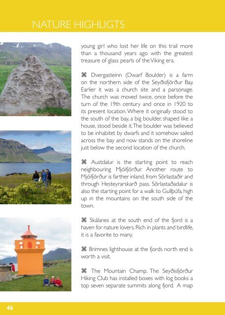
⌘ Dvergasteinn (Dwarf Boulder) is a farm<br />
on the northern side of the Seyðisfjörður Bay.<br />
Earlier it was a church site and a parsonage.<br />
<strong>The</strong> church was moved twice, once before the<br />
turn of the 19th century and once in 1920 to<br />
its present location. Where it originally stood to<br />
the south of the bay, a big boulder, shaped like a<br />
house, stood beside it. <strong>The</strong> boulder was believed<br />
to be inhabitet by dwarfs and it somehow sailed<br />
across the bay and now stands on the shoreline<br />
just below the second location of the church.<br />
⌘ Austdalur is the starting point to reach<br />
neighbouring Mjóifjörður. Another route to<br />
Mjóifjörður is farther inland, from Sörlastaðir and<br />
through Hesteyrarskarð pass. Sörlastaðadalur is<br />
also the starting point for a walk to Gullþúfa, high<br />
up in the mountains on the south side of the<br />
town.<br />
⌘ Skálanes at the south end of the fjord is a<br />
haven for nature lovers. Rich in plants and birdlife,<br />
it is a favorite to many.<br />
⌘ Brimnes lighthouse at the fjords north end is<br />
worth a visit.<br />
⌘ <strong>The</strong> Mountain Champ. <strong>The</strong> Seyðisfjörður<br />
Hiking Club has installed boxes with log books a<br />
top seven separate summits along fjord. A map