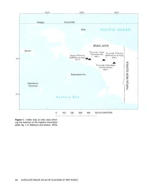
8°S Seram Kepulauan Tanimbar 132°E Waigeo _________ EQUATOR Figure 1. Index map of Irian Jaya show ing the location of the highest mountains (after fig. 1 in Peterson <strong>and</strong> others, 1973). Ngga Pilimsit (Idenburg-top) 4717m Kepulauan Aru Arafura Sea H2 SATELLITE IMAGE ATLAS OF GLACIERS OF THE WORLD 136°E 140°E PACIFIC OCEAN <strong>IRIAN</strong> JAVA MM PuncakTrikora (Wilhelmina-top) 4730m Puncak M<strong>and</strong>ala (Julianatop) 4640 m 100 200 300 400 500 KILOMETERS I
Van de Water, which descend from the same firn field), <strong>and</strong> the Southwall Hanging Glaciers. Details of these ice masses are tabulated by Miiller (1977). The Meren <strong>and</strong> Carstensz Glaciers flow westward in parallel glacial valleys, the Meren Valley <strong>and</strong> Yellow Valley, respectively (figs. 2, 3). In 1972, the Meren Glacier had an area of 1.9 km2 , a mean thickness of 40 m, <strong>and</strong> measured surface velocities of up to 30 m a -1 ; the Carstensz Glacier had an area of 0.9 km2 , a mean thickness of 38 m, <strong>and</strong> measured surface velocities of up to 18 m a -1 . The morphology <strong>and</strong> dynamics of both these glaciers are described by Allison (1975 <strong>and</strong> 1976). Seasonal climatic variations on the Puncak Jaya massif are very slight. Monthly mean temperatures vary by less than 0.5 °C during the year, <strong>and</strong> there appears to be no marked seasonal variation in precipitation, radiation, or cloud cover (Allison <strong>and</strong> Bennett, 1976). As a consequence, the net balance of the glaciers remains seasonally uniform, <strong>and</strong> ablation occurs year round below the equilibrium line; above the equilibrium line accumulation occurs year round. Hence the snowline elevation on the glacier remains near the equilibrium-line altitude except for short periods after heavy snowfalls. Mass-balance measurements in 1972 in dicated an equilibrium-line altitude of 4,580 m with the net annual bal ance reaching + 1 m a -1 water equivalent (w.e.) at 4,800 m elevation, near the top of the glaciers, <strong>and</strong> - 5 m a- 1 w.e. at 4,400 m, near the ter mini. Because ablation occurs throughout the year in the ablation zone, the vertical budget gradient (activity index) for these glaciers is high. Both the Meren <strong>and</strong> Carstensz Glaciers had a negative mass budget in 1972, which is consistent with their observed retreat. The ice extent on the Puncak Jaya massif is small, but the area is one of only a few present-day, ice-covered equatorial regions. The rapid <strong>and</strong> continuing retreat of the glaciers during this century indicates that the mass budget has been consistently negative. This suggests a climatic change, of which the glaciers are a sensitive indicator. Using a numerical model of the glaciers <strong>and</strong> their dynamics, Allison <strong>and</strong> Kruss (1977) estimated the change in mass budget necessary to give the observed retreat, between about 1850 <strong>and</strong> 1972, of more than 2 km for the Carstensz <strong>and</strong> more than 3 km for the Meren Glacier. They showed that a steady rise of the equilibrium-line elevation at a rate of 80 m per cen tury allowed the model to match the observed retreat <strong>and</strong> that the most likely explanation for the mass-balance change was a warming of the regional air temperature by 0.6 °C per century. Subsequent observations show that the terminus of the Meren Glacier retreated about 200 m between 1973 <strong>and</strong> 1976 <strong>and</strong> that the Carstensz Glacier retreated 50 m during the same period of time (Dr. L. Hansen, pers. commun.). Continued monitoring of the glaciers is obviously needed because of the climatic implications. Far less, however, is known about the other glaciers in Irian Jaya. The ice caps on Ngga Pilimsit (about 12 km northwest of Puncak Jaya) <strong>and</strong> on Puncak M<strong>and</strong>ala each have a diameter of only several hundred meters (Mercer, 1967; Peterson <strong>and</strong> others, 1973). GLACIERS OF <strong>IRIAN</strong> <strong>JAYA</strong>, <strong>INDONESIA</strong> H3