

IRIAN JAYA, INDONESIA, and NEW ZEALAND
IRIAN JAYA, INDONESIA, and NEW ZEALAND
IRIAN JAYA, INDONESIA, and NEW ZEALAND

You also want an ePaper? Increase the reach of your titles
YUMPU automatically turns print PDFs into web optimized ePapers that Google loves.
Because the Southwall Hanging Glaciers are less than 100 m wide, they<br />
do not show in the contours made from a scanning interval of 200 m, but<br />
they can be seen on the optically enlarged image.<br />
The December 1974 ice boundary shown in figure 11 has been plotted<br />
from a combination of the density contours <strong>and</strong> the optical enlargement<br />
<strong>and</strong> is compared with the 1972 CGE ice boundary. The inset map of the<br />
Ngga Pilimsit ice cap, the first produced for that area, has been derived<br />
from the density contours of the MSS b<strong>and</strong> 6 image. Table 2 shows the<br />
1974 ice areas compared with 1972 areas, after the latter have been cor<br />
rected for map errors revealed by the satellite data. Continued retreat of<br />
the ice fields between 1972 <strong>and</strong> 1974 is apparent.<br />
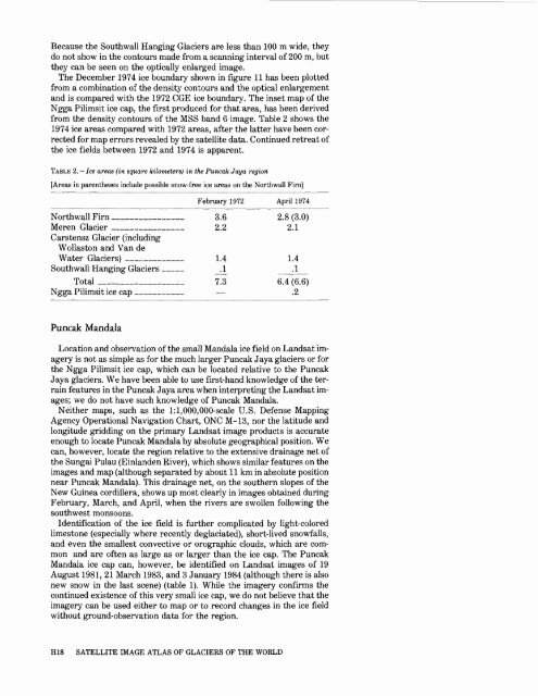
TABLE 2. Ice areas (in square kilometers) in the Puncak Jaya region<br />
[Areas in parentheses include possible snow-free ice areas on the Northwall Firn]<br />
February 1972 April 1974<br />
Northwall Firn ___________ 3.6 2.8(3.0)<br />
Meren Glacier __________ 2.2 2.1<br />
Carstensz Glacier (including<br />
Wollaston <strong>and</strong> Van de<br />
Water Glaciers) _________ 1.4 1.4<br />
Southwall Hanging Glaciers ___ .1 .1<br />
Total _____________ 7.3 6.4 (6.6)<br />
Ngga Pilimsit ice cap _______ .2<br />
Puncak M<strong>and</strong>ala<br />
Location <strong>and</strong> observation of the small M<strong>and</strong>ala ice field on L<strong>and</strong>sat im<br />
agery is not as simple as for the much larger Puncak Jaya glaciers or for<br />
the Ngga Pilimsit ice cap, which can be located relative to the Puncak<br />
Jaya glaciers. We have been able to use first-h<strong>and</strong> knowledge of the ter<br />
rain features in the Puncak Jaya area when interpreting the L<strong>and</strong>sat im<br />
ages; we do not have such knowledge of Puncak M<strong>and</strong>ala.<br />
Neither maps, such as the l:l,000,000-scale U.S. Defense Mapping<br />
Agency Operational Navigation Chart, ONC M-13, nor the latitude <strong>and</strong><br />
longitude gridding on the primary L<strong>and</strong>sat image products is accurate<br />
enough to locate Puncak M<strong>and</strong>ala by absolute geographical position. We<br />
can, however, locate the region relative to the extensive drainage net of<br />
the Sungai Pulau (Einl<strong>and</strong>en River), which shows similar features on the<br />
images <strong>and</strong> map (although separated by about 11 km in absolute position<br />
near Puncak M<strong>and</strong>ala). This drainage net, on the southern slopes of the<br />
New Guinea Cordillera, shows up most clearly in images obtained during<br />
February, March, <strong>and</strong> April, when the rivers are swollen following the<br />
southwest monsoons.<br />
Identification of the ice field is further complicated by light-colored<br />
limestone (especially where recently deglaciated), short-lived snowfalls,<br />
<strong>and</strong> even the smallest convective or orographic clouds, which are com<br />
mon <strong>and</strong> are often as large as or larger than the ice cap. The Puncak<br />
M<strong>and</strong>ala ice cap can, however, be identified on L<strong>and</strong>sat images of 19<br />
August 1981, 21 March 1983, <strong>and</strong> 3 January 1984 (although there is also<br />
new snow in the last scene) (table 1). While the imagery confirms the<br />
continued existence of this very small ice cap, we do not believe that the<br />
imagery can be used either to map or to record changes in the ice field<br />
without ground-observation data for the region.<br />
HIS SATELLITE IMAGE ATLAS OF GLACIERS OF THE WORLD


