Montco. Law Reporter; Vol. 144; Issue 50 - Montgomery Bar ...
Montco. Law Reporter; Vol. 144; Issue 50 - Montgomery Bar ...
Montco. Law Reporter; Vol. 144; Issue 50 - Montgomery Bar ...
You also want an ePaper? Increase the reach of your titles
YUMPU automatically turns print PDFs into web optimized ePapers that Google loves.
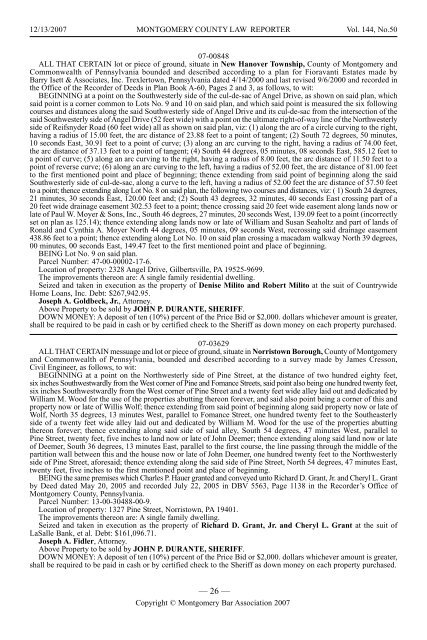
12/13/2007 MONTGOMERY COUNTY LAW REPORTER <strong>Vol</strong>. <strong>144</strong>, No.<strong>50</strong><br />
07-00848<br />
ALL THAT CERTAIN lot or piece of ground, situate in New Hanover Township, County of <strong>Montgomery</strong> and<br />
Commonwealth of Pennsylvania bounded and described according to a plan for Fioravanti Estates made by<br />
<strong>Bar</strong>ry Isett & Associates, Inc. Trexlertown, Pennsylvania dated 4/14/2000 and last revised 9/6/2000 and recorded in<br />
the Office of the Recorder of Deeds in Plan Book A-60, Pages 2 and 3, as follows, to wit:<br />
BEGINNING at a point on the Southwesterly side of the cul-de-sac of Angel Drive, as shown on said plan, which<br />
said point is a corner common to Lots No. 9 and 10 on said plan, and which said point is measured the six following<br />
courses and distances along the said Southwesterly side of Angel Drive and its cul-de-sac from the intersection of the<br />
said Southwesterly side of Angel Drive (52 feet wide) with a point on the ultimate right-of-way line of the Northwesterly<br />
side of Reifsnyder Road (60 feet wide) all as shown on said plan, viz: (1) along the arc of a circle curving to the right,<br />
having a radius of 15.00 feet, the arc distance of 23.88 feet to a point of tangent; (2) South 72 degrees, <strong>50</strong> minutes,<br />
10 seconds East, 30.91 feet to a point of curve; (3) along an arc curving to the right, having a radius of 74.00 feet,<br />
the arc distance of 37.13 feet to a point of tangent; (4) South 44 degrees, 05 minutes, 08 seconds East, 585.12 feet to<br />
a point of curve; (5) along an arc curving to the right, having a radius of 8.00 feet, the arc distance of 11.<strong>50</strong> feet to a<br />
point of reverse curve; (6) along an arc curving to the left, having a radius of 52.00 feet, the arc distance of 81.00 feet<br />
to the first mentioned point and place of beginning; thence extending from said point of beginning along the said<br />
Southwesterly side of cul-de-sac, along a curve to the left, having a radius of 52.00 feet the arc distance of 57.<strong>50</strong> feet<br />
to a point; thence extending along Lot No. 8 on said plan, the following two courses and distances, viz: ( 1) South 24 degrees,<br />
21 minutes, 30 seconds East, 120.00 feet and; (2) South 43 degrees, 32 minutes, 40 seconds East crossing part of a<br />
20 feet wide drainage easement 302.53 feet to a point; thence crossing said 20 feet wide easement along lands now or<br />
late of Paul W. Moyer & Sons, Inc., South 46 degrees, 27 minutes, 20 seconds West, 139.09 feet to a point (incorrectly<br />
set on plan as 125.14); thence extending along lands now or late of William and Susan Seaholtz and part of lands of<br />
Ronald and Cynthia A. Moyer North 44 degrees, 05 minutes, 09 seconds West, recrossing said drainage easement<br />
438.86 feet to a point; thence extending along Lot No. 10 on said plan crossing a macadam walkway North 39 degrees,<br />
00 minutes, 00 seconds East, 149.47 feet to the first mentioned point and place of beginning.<br />
BEING Lot No. 9 on said plan.<br />
Parcel Number: 47-00-00002-17-6.<br />
Location of property: 2328 Angel Drive, Gilbertsville, PA 19525-9699.<br />
The improvements thereon are: A single family residential dwelling.<br />
Seized and taken in execution as the property of Denise Milito and Robert Milito at the suit of Countrywide<br />
Home Loans, Inc. Debt: $267,942.95.<br />
Joseph A. Goldbeck, Jr., Attorney.<br />
Above Property to be sold by JOHN P. DURANTE, SHERIFF.<br />
DOWN MONEY: A deposit of ten (10%) percent of the Price Bid or $2,000. dollars whichever amount is greater,<br />
shall be required to be paid in cash or by certified check to the Sheriff as down money on each property purchased.<br />
07-03629<br />
ALL THAT CERTAIN messuage and lot or piece of ground, situate in Norristown Borough, County of <strong>Montgomery</strong><br />
and Commonwealth of Pennsylvania, bounded and described according to a survey made by James Cresson,<br />
Civil Engineer, as follows, to wit:<br />
BEGINNING at a point on the Northwesterly side of Pine Street, at the distance of two hundred eighty feet,<br />
six inches Southwestwardly from the West corner of Pine and Fomance Streets, said point also being one hundred twenty feet,<br />
six inches Southwestwardly from the West corner of Pine Street and a twenty feet wide alley laid out and dedicated by<br />
William M. Wood for the use of the properties abutting thereon forever, and said also point being a corner of this and<br />
property now or late of Willis Wolf; thence extending from said point of beginning along said property now or late of<br />
Wolf, North 35 degrees, 13 minutes West, parallel to Fomance Street, one hundred twenty feet to the Southeasterly<br />
side of a twenty feet wide alley laid out and dedicated by William M. Wood for the use of the properties abutting<br />
thereon forever; thence extending along said side of said alley, South 54 degrees, 47 minutes West, parallel to<br />
Pine Street, twenty feet, five inches to land now or late of John Deemer; thence extending along said land now or late<br />
of Deemer, South 36 degrees, 13 minutes East, parallel to the first course, the line passing through the middle of the<br />
partition wall between this and the house now or late of John Deemer, one hundred twenty feet to the Northwesterly<br />
side of Pine Street, aforesaid; thence extending along the said side of Pine Street, North 54 degrees, 47 minutes East,<br />
twenty feet, five inches to the first mentioned point and place of beginning.<br />
BEING the same premises which Charles P. Hauer granted and conveyed unto Richard D. Grant, Jr. and Cheryl L. Grant<br />
by Deed dated May 20, 2005 and recorded July 22, 2005 in DBV 5563, Page 1138 in the Recorder’s Office of<br />
<strong>Montgomery</strong> County, Pennsylvania.<br />
Parcel Number: 13-00-30488-00-9.<br />
Location of property: 1327 Pine Street, Norristown, PA 19401.<br />
The improvements thereon are: A single family dwelling.<br />
Seized and taken in execution as the property of Richard D. Grant, Jr. and Cheryl L. Grant at the suit of<br />
LaSalle Bank, et al. Debt: $161,096.71.<br />
Joseph A. Fidler, Attorney.<br />
Above Property to be sold by JOHN P. DURANTE, SHERIFF.<br />
DOWN MONEY: A deposit of ten (10%) percent of the Price Bid or $2,000. dollars whichever amount is greater,<br />
shall be required to be paid in cash or by certified check to the Sheriff as down money on each property purchased.<br />
— 26 —<br />
Copyright © <strong>Montgomery</strong> <strong>Bar</strong> Association 2007


