Montco. Law Reporter; Vol. 144; Issue 50 - Montgomery Bar ...
Montco. Law Reporter; Vol. 144; Issue 50 - Montgomery Bar ...
Montco. Law Reporter; Vol. 144; Issue 50 - Montgomery Bar ...
Create successful ePaper yourself
Turn your PDF publications into a flip-book with our unique Google optimized e-Paper software.
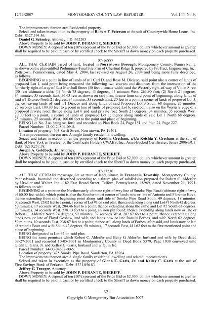
12/13/2007 MONTGOMERY COUNTY LAW REPORTER <strong>Vol</strong>. <strong>144</strong>, No.<strong>50</strong><br />
The improvements thereon are: Residential property.<br />
Seized and taken in execution as the property of Robert F. Peterson at the suit of Countrywide Home Loans, Inc.<br />
Debt: $327,194.56.<br />
Daniel G. Schmieg, Attorney. I.D. #62205<br />
Above Property to be sold by JOHN P. DURANTE, SHERIFF.<br />
DOWN MONEY: A deposit of ten (10%) percent of the Price Bid or $2,000. dollars whichever amount is greater,<br />
shall be required to be paid in cash or by certified check to the Sheriff as down money on each property purchased.<br />
07-16887<br />
ALL THAT CERTAIN parcel of land, located in Norristown Borough, <strong>Montgomery</strong> County, Pennsylvania,<br />
as shown on the plan entitled Preliminary/Final Site Plan of Chestnut Ridge II, prepared by ProTract, Engineering, Inc.,<br />
Pottstown, Pennsylvania, dated May 4, 2004, last revised on August 26, 2004 and being more fully described,<br />
as follows:<br />
BEGINNING at a point in line of lands of n/1 Carl D. and Rose M. Dicicco, said point also a corner of lands of<br />
proposed Lot 1, said point being measured the following two courses and distances from the intersection of the<br />
Northerly right-of-way of East Marshall Street (<strong>50</strong> feet ultimate width) and the Westerly right-of-way of Violet Street<br />
(<strong>50</strong> feet ultimate width): (1) North 73 degrees, 43 degrees, 43 minutes West, 263.90 feet; (2) North 21 degrees,<br />
34 minutes, 35 seconds East, 56.63 feet as shown on said plan; thence from said point of beginning, along lands of<br />
said n/1 Dicicco North 21 degrees, 34 minutes, 35 seconds East, 20 feet to a point, a corner of lands of proposed Lot 3;<br />
thence leaving lands of said n/1 Dicicco and along lands of said Proposed Lot 3 South 68 degrees, 25 minutes,<br />
25 seconds East, 100.00 feet to a point in line of lands of proposed Lot 6, said point also on the Westerly edge of a<br />
proposed private road; thence along Lot 6 and said private road South 21 degrees, 34 minutes, 35 seconds West,<br />
20.00 feet to a point, a corner of lands of proposed Lot 1; thence along lands of said Lot 1 North 68 degrees,<br />
25 minutes, 25 seconds West, 100.00 feet to the point and place of beginning.<br />
BEING Lot No. 2 as being set forth and recorded on Plan Book 24, Page 151 and Plan 24, Page 227.<br />
Parcel Number: 13-00-24804-09-5.<br />
Location of property: 603 Swift Street, Norristown, PA 19401.<br />
The improvements thereon are: A single family residential dwelling.<br />
Seized and taken in execution as the property of Keishia Gresham, a/k/a Keishia Y. Gresham at the suit of<br />
Bank of New York as Trustee for the Certificate Holders CWABS, Inc., Asset-Backed Certificates, Series 2006-BC3.<br />
Debt: $210,257.58.<br />
Joseph A. Goldbeck, Jr., Attorney.<br />
Above Property to be sold by JOHN P. DURANTE, SHERIFF.<br />
DOWN MONEY: A deposit of ten (10%) percent of the Price Bid or $2,000. dollars whichever amount is greater,<br />
shall be required to be paid in cash or by certified check to the Sheriff as down money on each property purchased.<br />
07-17230<br />
ALL THAT CERTAIN messuage, lot or tract of land, situate in Franconia Township, <strong>Montgomery</strong> County,<br />
Pennsylvania, bounded and described according to a future plan of subdivision prepared for Robert C. Alderfer,<br />
by Urwiler and Walter, Inc., 182 East Broad Street, Telford, Pennsylvania, 18969, dated November 21, 1991,<br />
as follows, to wit:<br />
BEGINNING at a point on the Northwesterly ultimate right-of-way line of Smoke Pipe Road (ultimate right-of-way<br />
of 60.00 feet wide), which point is also the Southernmost corner of lands now or late of Antonia and Florence Bova;<br />
thence extending from said beginning point along said side of Smoke Pipe Road South 49 degrees, 18 minutes,<br />
00 seconds West, 25.02 feet to a point, a corner of Lot #1 on said plan; thence extending along said Lot #1 North 42 degrees,<br />
<strong>50</strong> minutes, 17 seconds West, 204.46 feet to a point; thence extending along the same and Lot #2 South 63 degrees,<br />
30 minutes, 34 seconds West, 278.13 feet to a point, an iron pin found; thence extending along lands now or late or<br />
Robert C. Alderfer North 24 degrees, 57 minutes, 37 seconds West, 202.82 feet to a point; thence extending along<br />
lands now or late of Floyd Goshaw, and wife and lands now or late Ronald Forbes, and wife North 62 degrees,<br />
59 minutes, 10 seconds East, 238.67 feet to a point; thence still along lands of Forbes, aforesaid, and lands now or late<br />
of Antonia Bova and wife South 42 degrees, <strong>50</strong> minutes, 17 seconds East, 411.62 feet to the first mentioned point and<br />
place of beginning.<br />
BEING designated as Lot #2 on said plan.<br />
BEING the same premises which Robert C. Alderfer and Betty G. Alderfer, husband and wife by Deed dated<br />
09-27-2001 and recorded 10-05-2001 in <strong>Montgomery</strong> County in Deed Book 5379, Page 1938 conveyed unto<br />
Glenn E. Garis, Jr. and Kelley C. Garis, husband and wife, in fee.<br />
Parcel Number: 34-00-04632-00-5.<br />
Location of property: 425 Smoke Pipe Road, Souderton, PA 18964.<br />
The improvements thereon are: A single family residential dwelling and related improvements.<br />
Seized and taken in execution as the property of Glenn E. Garis, Jr. and Kelley C. Garis at the suit of<br />
First Savings Bank of Perkasie. Debt: $321,056.83.<br />
Jeffrey G. Trauger, Attorney.<br />
Above Property to be sold by JOHN P. DURANTE, SHERIFF.<br />
DOWN MONEY: A deposit of ten (10%) percent of the Price Bid or $2,000. dollars whichever amount is greater,<br />
shall be required to be paid in cash or by certified check to the Sheriff as down money on each property purchased.<br />
— 32 —<br />
Copyright © <strong>Montgomery</strong> <strong>Bar</strong> Association 2007


