Montco. Law Reporter; Vol. 144; Issue 50 - Montgomery Bar ...
Montco. Law Reporter; Vol. 144; Issue 50 - Montgomery Bar ...
Montco. Law Reporter; Vol. 144; Issue 50 - Montgomery Bar ...
Create successful ePaper yourself
Turn your PDF publications into a flip-book with our unique Google optimized e-Paper software.
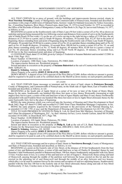
12/13/2007 MONTGOMERY COUNTY LAW REPORTER <strong>Vol</strong>. <strong>144</strong>, No.<strong>50</strong><br />
07-13679<br />
ALL THAT CERTAIN lot or piece of ground, with the buildings and improvements thereon erected, situate in<br />
West Norriton Township, County of <strong>Montgomery</strong> and Commonwealth of Pennsylvania, bounded and described in<br />
accordance with a map of subdivision of Oakland Farms, Section 1 made for Oakland Associates by Yerkes Associates,<br />
Inc., Consulting Engineers, Bryn Mawr, Pennsylvania, dated June 19, 1974 revised October 16, 1975 as recorded in<br />
the Office of the Recorder of Deeds of <strong>Montgomery</strong> County in Plan Book A-26, Page 26, last revised February 14, 1977,<br />
as follows, to wit:<br />
BEGINNING at a point on the Southwesterly side of Dairy Lane (<strong>50</strong> feet wide) a corner of Lot No. 60 as shown on<br />
said plan said point being measured the two following courses and distances from a point of curve on the Southeasterly<br />
side of Stable Road (<strong>50</strong> feet wide): (1) on the arc of a circle curving to the right having a radius of 15.00 feet, the arc<br />
distances of 23.39 feet to a point; and (2) South 49 degrees, 49 minutes, <strong>50</strong> seconds East, 412.87 feet to the point of<br />
beginning; thence extending from said point of beginning along the Southwesterly side of Dairy Lane South 49 degrees,<br />
49 minutes, <strong>50</strong> seconds East, 85.00 feet to a point a corner of Lot No. 62 on said plan; thence extending along said Lot No. 62<br />
and Lot No. 63 South 40 degrees, 10 minutes, 10 seconds West, 200.00 feet to a point a corner of Lot No. 52, on said<br />
plan; thence extending along said Lot No. 52 North 49 degrees, 49 minutes West, 85.00 feet to a point a corner of<br />
Lot No. 60 aforesaid; thence extending along said Lot No.60 North 40 degrees, 10 minutes, 10 seconds East,<br />
85.00 feet to the first mentioned point and place of beginning.<br />
(1) VESTED BY Deed, dated 12/14/2000, given by Carolyn J. Frederick to Suzanne Balestieri and recorded 1/2/2001 in<br />
Book 5344, Page 1812.<br />
Parcel Number: 63-00-01852-10-1.<br />
Location of property: 2406 Dairy Lane, Norristown, PA 19403-2668.<br />
The improvements thereon are: Residential property.<br />
Seized and taken in execution as the property of Suzanne Balestrieri at the suit of Countrywide Home Loans, Inc.<br />
Debt: $280,451.16.<br />
Daniel G. Schmieg, Attorney. I.D. #62205<br />
Above Property to be sold by JOHN P. DURANTE, SHERIFF.<br />
DOWN MONEY: A deposit of ten (10%) percent of the Price Bid or $2,000. dollars whichever amount is greater,<br />
shall be required to be paid in cash or by certified check to the Sheriff as down money on each property purchased.<br />
07-15295<br />
ALL THAT CERTAIN frame messuage or tenement and lot or piece of land, situate in Pottstown Borough,<br />
County of <strong>Montgomery</strong>, and Commonwealth of Pennsylvania, on the South side of Apple Street, East of Franklin Street,<br />
bounded and described, as follows, to wit:<br />
BEGINNING at the South side of Apple Street at a corner of lot now or later of the Estate of Henry Black;<br />
thence by the same, Southwardly one hundred fifty-three feet more or less; thence Westwardly (measuring at right<br />
angles) forty feet to a post, a corner of this and land now or late of Agnes Shipley and Mary Evans; thence Northwardly<br />
and parallel with said Franklin Street one hundred fifty-three feet more or less to Apple Street aforesaid; thence by the<br />
same Eastwardly forty feet to the place of beginning.<br />
BEING the same premises which was conveyed unto the Secretary of Housing and Urban Development in Deed<br />
Book 5462, Page 425 dated 9/2/2002 and recorded 6/27/2003 from Chase Manhattan Mortgage Corporation, in fee.<br />
BEING the same property acquired by the Grantor pursuant to the provisions of the National Housing Act,<br />
as amended (12 USC 1701 et seq.) and the Department of Housing and Urban Development Act (42 USC (3531).<br />
TITLE TO SAID PREMISES IS VESTED IN Philip K. Loh, by Deed from Mel Martinez, Secretary of Housing<br />
and Urban Development of Washington, D.C., by their Attorney-in-Fact, Lewis Arnold Carlson, dated 08/19/2003,<br />
recorded 10/10/2003, in Deed Book 5477, Page 788.<br />
Parcel Number: 16-00-00468-00-2.<br />
Location of property: 418 Apple Street, Pottstown, PA 19464.<br />
The improvements thereon are: Residential property.<br />
Seized and taken in execution as the property of Philip K. Loh at the suit of U.S. Bank National Association,<br />
as Trustee for the Structured Asset Investment Loan Trust, 2006-BNC2. Debt: $141,241.05.<br />
Daniel G. Schmieg, Attorney. I.D. #62205<br />
Above Property to be sold by JOHN P. DURANTE, SHERIFF.<br />
DOWN MONEY: A deposit of ten (10%) percent of the Price Bid or $2,000. dollars whichever amount is greater,<br />
shall be required to be paid in cash or by certified check to the Sheriff as down money on each property purchased.<br />
07-16224<br />
ALL THAT CERTAIN messuage and lot or piece of land, situate in Norristown Borough, County of <strong>Montgomery</strong><br />
and State of Pennsylvania, bounded and described, as follows, to wit:<br />
BEGINNING at a point on the Easterly side of Airy Street, at the distance of 30 feet Southeasterly from the East<br />
corner of Airy and Buttonwood Streets, a corner of this and land now or late of Charles H. Homsher; thence by said<br />
Homsher’s land Northeasterly parallel to Buttonwood Street, 100 feet; thence Southeasterly and parallel with Airy Street<br />
15 feet, 4 inches more or less, to a corner of this and land now or late of Eugene C. Honeywell; thence along said land<br />
of Honeywell, passing through the middle of the partition wall between the house erected on this lot and the one<br />
erected on the adjoining lot of said Honeywell and through the middle of an alley between said two houses,<br />
which alley is to be used in common forever by the owners and occupiers of said two adjoining houses, Southwesterly<br />
parallel with the first line 100 feet to the Easterly side of Airy Street aforesaid; thence along said side of Airy Street<br />
Northwesterly 15 feet, 4 inches more or less to the place of beginning.<br />
— 30 —<br />
Copyright © <strong>Montgomery</strong> <strong>Bar</strong> Association 2007


