Montco. Law Reporter; Vol. 144; Issue 50 - Montgomery Bar ...
Montco. Law Reporter; Vol. 144; Issue 50 - Montgomery Bar ...
Montco. Law Reporter; Vol. 144; Issue 50 - Montgomery Bar ...
You also want an ePaper? Increase the reach of your titles
YUMPU automatically turns print PDFs into web optimized ePapers that Google loves.
12/13/2007 MONTGOMERY COUNTY LAW REPORTER <strong>Vol</strong>. <strong>144</strong>, No.<strong>50</strong><br />
07-10178<br />
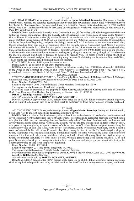
ALL THAT CERTAIN lot or piece of ground, situate in Upper Moreland Township, <strong>Montgomery</strong> County,<br />
Pennsylvania, bounded and described according to a subdivision plan of Colonial Manor X made for Dominic LaRosa<br />
by Charles E. Shoemaker, Inc., Engineers and Surveyors, Abington, Pennsylvania, dated August 15, 1980 and last<br />
revised June 8, 1981 and recorded in and for the County of <strong>Montgomery</strong> at Norristown, Pennsylvania, in Plan Book A-44,<br />
Page 459, as follows, to wit:<br />
BEGINNING at a point on the Easterly side of Centennial Road (<strong>50</strong> feet wide), said point being measured the two<br />
following courses and distances along the Easterly side of Centennial Road from a point of curve on the Northerly<br />
side of Pioneer Road (<strong>50</strong> feet wide): (1) leaving Pioneer Road on the arc of a circle curving to the right, having a<br />
radius of 20 feet, the arc distance of 31.42 feet to a point of tangent; and (2) North 3 degrees, 45 minutes, 40 seconds East,<br />
80 feet to the point of beginning, said point also being a corner of Lot 22 as shown on the above mentioned plan;<br />
thence extending from said point of beginning along the Easterly side of Centennial Road North 3 degrees,<br />
45 minutes, 40 seconds East, 100 feet to a point, a corner of Lot 24 as shown on the above mentioned plan;<br />
thence extending along the same South 86 degrees, 14 minutes, 20 seconds East, 140.86 feet to a point in line of Lot 25<br />
as shown on the above mentioned plan; thence extending partly along the same and partly along Lot 21 as shown on<br />
the above mentioned plan, South 13 degrees, 45 minutes, 40 seconds West, 100 feet to a point, a corner of Lot 22 as<br />
shown on the above mentioned plan; thence extending along the same North 86 degrees, 14 minutes, 20 seconds West,<br />
140.86 feet to the first mentioned point and place of beginning.<br />
CONTAINING in area 14,086 square feet more or less.<br />
BEING Lot No. 23 as shown on the above mentioned plan.<br />
BEING the same premises which Dominic LaRosa, by Indenture bearing date 10/31/1984 and recorded 11/7/1984<br />
in the Office of the Recorder of Deeds, in and for the County of <strong>Montgomery</strong> in Deed Book 4752, Page 84 etc.,<br />
granted and conveyed unto Daniel J. McIntyre and Diane T. McIntyre, husband and wife, in fee.<br />
RECORD OWNER<br />
TITLE TO SAID PREMISES IS VESTED IN Gina Conroy, by Deed from Daniel J. McIntyre and Diane T. McIntyre,<br />
husband and wife, dated 06/21/2005, recorded 07/05/2005, in Deed Book 5560, Page 2208.<br />
Parcel Number: 59-00-02673-12-1.<br />
Location of property: 2695 Centennial Road, Upper Moreland Township, PA 19040.<br />
The improvements thereon are: Residential property.<br />
Seized and taken in execution as the property of Gina Conroy, a/k/a Gina M. Conroy at the suit of Deutsche<br />
Bank Trust Company, f/k/a Bankers Trust Company as Trustee. Debt: $310,213.04.<br />
Daniel G. Schmieg, Attorney. I.D. #62205<br />
Above Property to be sold by JOHN P. DURANTE, SHERIFF.<br />
DOWN MONEY: A deposit of ten (10%) percent of the Price Bid or $2,000. dollars whichever amount is greater,<br />
shall be required to be paid in cash or by certified check to the Sheriff as down money on each property purchased.<br />
07-10322<br />
ALL THOSE TWO CERTAIN lots, and messuage, situate in Upper Merion Township, County and State aforesaid,<br />
being Lots Nos. 11 and 12 bounded and described, as follows, to wit:<br />
BEGINNING at a point on the Southwesterly side of Tose Road at the distance of two hundred and fourteen and<br />
seven-tenths feet Northwesterly from the Northwest corner of Tose Road and a certain ten feet wide alley laid out on<br />
said plan for public use, and extending from the Southwesterly side of Tose Road Southwesterly one hundred and<br />
seventy feet to a point a corner; thence Northwesterly along the rear line of all the lots laid out on said plan to Stewart Street,<br />
said point of beginning being at a point a corner of this and the line of Lot No. 10 on said plan; thence along the<br />
Southwesterly side of said Tose Road, North twenty-four degrees, twenty-two minutes West, forty feet to a point a<br />
corner of this and the line of Lot No. 13 on said plan; thence along the line of Lot No. 13, South sixty-five degrees,<br />
twenty-six minutes West, one hundred and sixty-eight and nine-tenths feet to the Northeasterly side of the hereinbefore<br />
mentioned ten feet wide alley way; and thence along said side of said alley way South twenty-four degrees,<br />
twenty-two minutes East, forty feet to the line of Lot No. 10 on said plan; thence along the line of Lot No. 10 on said<br />
plan, North sixty-five degrees, twenty-six minutes East, one hundred and sixty-eight and nine-tenths feet to the<br />
Southwesterly side of Tose Road the place of beginning.<br />
Parcel Number: 58-00-19027-00-4.<br />
Location of property: 231 Tose Street, Bridgeport, PA 19405.<br />
The improvements thereon are: A single family residential dwelling.<br />
Seized and taken in execution as the property of David A. Roop at the suit of GRP Loan, LLC. Debt: $156,605.63.<br />
Joseph A. Goldbeck, Jr., Attorney.<br />
Above Property to be sold by JOHN P. DURANTE, SHERIFF.<br />
DOWN MONEY: A deposit of ten (10%) percent of the Price Bid or $2,000. dollars whichever amount is greater,<br />
shall be required to be paid in cash or by certified check to the Sheriff as down money on each property purchased.<br />
— 28 —<br />
Copyright © <strong>Montgomery</strong> <strong>Bar</strong> Association 2007


