Historic Lafayette
An illustrated history of the city of Lafayette and the Lafayette Parish area, paired with the histories of companies, families and organizations that make the region great.
An illustrated history of the city of Lafayette and the Lafayette Parish area, paired with the histories of companies, families and organizations that make the region great.

You also want an ePaper? Increase the reach of your titles
YUMPU automatically turns print PDFs into web optimized ePapers that Google loves.
LAFAYETTE PARISH:<br />
AN INTRODUCTION<br />
<strong>Lafayette</strong> Parish today is defined as many things: the Hub City, the capital of Cajun Country, the<br />
heart of Acadiana. But before it took on these definitions, even before it was defined as a parish, the<br />
geography and the environment of the area shaped the place we now call <strong>Lafayette</strong>.<br />
People and cultures come and go, but the land and its layout change only slowly, sometimes<br />
over centuries but usually over millennia. And the soil, the water, and the vegetation of an area<br />
provide clues to understanding that place’s history, its inhabitants, and its development.<br />
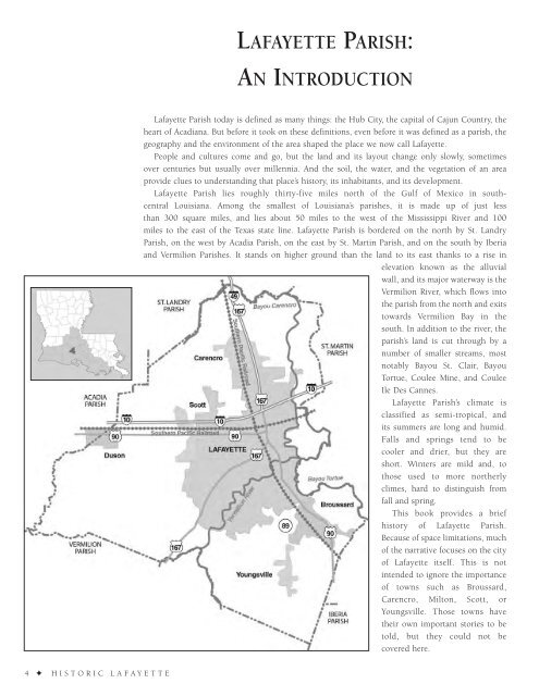
<strong>Lafayette</strong> Parish lies roughly thirty-five miles north of the Gulf of Mexico in southcentral<br />
Louisiana. Among the smallest of Louisiana’s parishes, it is made up of just less<br />
than 300 square miles, and lies about 50 miles to the west of the Mississippi River and 100<br />
miles to the east of the Texas state line. <strong>Lafayette</strong> Parish is bordered on the north by St. Landry<br />
Parish, on the west by Acadia Parish, on the east by St. Martin Parish, and on the south by Iberia<br />
and Vermilion Parishes. It stands on higher ground than the land to its east thanks to a rise in<br />
elevation known as the alluvial<br />
wall, and its major waterway is the<br />
Vermilion River, which flows into<br />
the parish from the north and exits<br />
towards Vermilion Bay in the<br />
south. In addition to the river, the<br />
parish’s land is cut through by a<br />
number of smaller streams, most<br />
notably Bayou St. Clair, Bayou<br />
Tortue, Coulee Mine, and Coulee<br />
Ile Des Cannes.<br />
<strong>Lafayette</strong> Parish’s climate is<br />
classified as semi-tropical, and<br />
its summers are long and humid.<br />
Falls and springs tend to be<br />
cooler and drier, but they are<br />
short. Winters are mild and, to<br />
those used to more northerly<br />
climes, hard to distinguish from<br />
fall and spring.<br />
This book provides a brief<br />
history of <strong>Lafayette</strong> Parish.<br />
Because of space limitations, much<br />
of the narrative focuses on the city<br />
of <strong>Lafayette</strong> itself. This is not<br />
intended to ignore the importance<br />
of towns such as Broussard,<br />
Carencro, Milton, Scott, or<br />
Youngsville. Those towns have<br />
their own important stories to be<br />
told, but they could not be<br />
covered here.<br />
4 ✦ HISTORIC LAFAYETTE