*Celebrating Spatial Planning at TU Delft: 2008-2019. Edited by Stead, Bracken, Rooij & Rocco
This is a summary of the achievements of the session Spatial Planning & Strategy of the Department of Urbanism, Faculty of Architecture and the Built Environment, TU Delft, led by Professor Vincent Nadin between 2008 and 2019.
This is a summary of the achievements of the session Spatial Planning & Strategy of the Department of Urbanism, Faculty of Architecture and the Built Environment, TU Delft, led by Professor Vincent Nadin between 2008 and 2019.

You also want an ePaper? Increase the reach of your titles
YUMPU automatically turns print PDFs into web optimized ePapers that Google loves.
46 <strong>Sp<strong>at</strong>ial</strong> <strong>Planning</strong> & Str<strong>at</strong>egy<br />
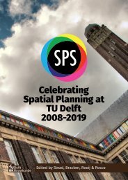
Applic<strong>at</strong>ion of Space<br />
Syntax for road<br />
altern<strong>at</strong>ives in Leiden<br />
AKKELIES VAN NES<br />
Fig. 24: Space Syntax map <strong>by</strong> A. van Nes.<br />
In recent years, the requirement<br />
for impact assessments on large<br />
urban intervention projects has<br />
emerged in various countries. The<br />
methods used are mostly based<br />
on traffic flow and travel-time d<strong>at</strong>a<br />
from road engineers. However, little<br />
<strong>at</strong>tention is paid to the economic<br />
effects of existing urban centres in<br />
these analyses.<br />
In 2011, a local action group in the<br />
Dutch Rijnland region asked us to<br />
carry out space syntax analyses of<br />
two different road altern<strong>at</strong>ives linking<br />
highways A4 and A44 through<br />
the Leiden and Voorschoten municipalities.<br />
As it turned out, the<br />
solution in favour of the local action<br />
group seemed to support the<br />
economic vitality in Leiden’s centre,<br />
whereas the altern<strong>at</strong>ive contributed<br />
to its segreg<strong>at</strong>ion.<br />
When comparing the results from<br />
these two projects, similarities<br />
between the best proposals for<br />
retaining a vital town centre can be<br />
found. It is about choosing an altern<strong>at</strong>ive<br />
road th<strong>at</strong> is well-connected<br />
to the existing centres. The challenge<br />
of better integr<strong>at</strong>ing space<br />
syntax in impact assessments is<br />
in convincing provincial administr<strong>at</strong>ions<br />
th<strong>at</strong> it can add useful<br />
indic<strong>at</strong>ors about economic vitality<br />
in existing and future economic<br />
centres <strong>at</strong> various scale levels.<br />
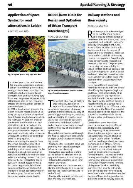
NODES (New TOols for<br />
Design and OpEr<strong>at</strong>ion<br />
of Urban Transport<br />
InterchangeS)<br />
AKKELIES VAN NES<br />
Fig. 25: Rotterdam central st<strong>at</strong>ion. Source:<br />
https://cordis.europa.eu/<br />
The overall objective of NODES<br />
was to build a toolbox to<br />
support European cities in the<br />
design and oper<strong>at</strong>ion of new or<br />
upgraded interchanges as a way of<br />
providing gre<strong>at</strong>er support, services,<br />
and s<strong>at</strong>isfaction to travellers and<br />
users, the interchange oper<strong>at</strong>ors<br />
themselves, and those societal<br />
and economic actors who depend<br />
on the efficiency of interchange<br />
oper<strong>at</strong>ions.<br />
The guidelines developed through<br />
the NODES consortium (consisting<br />
of 21 partners) covered the following<br />
issues:<br />
• Str<strong>at</strong>egies for integr<strong>at</strong>ed land-use<br />
planning with urban passenger<br />
infrastructure planning.<br />
• Innov<strong>at</strong>ive approaches rel<strong>at</strong>ing<br />
to the design of efficient new or<br />
upgraded transport interchanges.<br />
• Intermodal oper<strong>at</strong>ions and inform<strong>at</strong>ion<br />
provision.<br />
• Management and business models:<br />
the interchange as a business<br />
case for the local economy and in<br />
and of itself.<br />
• Energy-efficient and environmentally<br />
friendly interchanges.<br />
Railway st<strong>at</strong>ions and<br />
their vicinity<br />
AKKELIES VAN NES<br />
Rail transport is acknowledged<br />
as one of the most sustainable<br />
means of transport<strong>at</strong>ion<br />
between cities and towns, and is an<br />
important part in North Holland’s<br />
str<strong>at</strong>egy for development. A railway<br />
st<strong>at</strong>ion’s loc<strong>at</strong>ion in the built<br />
environment, and its degree of<br />
accessibility is, therefore, essential<br />
for it to be accessible to as many<br />
travellers as possible. Even though<br />
there already exists research on<br />
network cities and TOD principles<br />
concerning rail accessibility to<br />
urban centres and sub-centres, the<br />
sp<strong>at</strong>ial configur<strong>at</strong>ion of local street<br />
and road networks in a railway st<strong>at</strong>ion’s<br />
vicinity is seldom taken into<br />
account when discussing railway<br />
transport.<br />
Here, two different analytical<br />
methods were used with the aim of<br />
identifying the degree of regional<br />
and local inter-accessibility of all<br />
train st<strong>at</strong>ions in the Province of<br />
North Holland in the Netherlands.<br />
The space syntax method provided<br />
measurements on a street-net’s<br />
inter-accessibility on different scale<br />
levels, while the Node Place model<br />
analysis provided the degree of the<br />
st<strong>at</strong>ion’s <strong>at</strong>tractiveness in terms<br />
of place value and transport<strong>at</strong>ion<br />
value.<br />
Correl<strong>at</strong>ions were found between<br />
a st<strong>at</strong>ion’s degree of local<br />
and regional accessibility and<br />
the frequency of its timetables.<br />
When implementing and improving<br />
sustainable means of public<br />
transport<strong>at</strong>ion, urban functions<br />
(such as dwellings, shops, services,<br />
workshops, and offices) have to<br />
be a short walking distance from<br />
st<strong>at</strong>ions, and the street network<br />
must be easily understandable<br />
for way-finding. The results of this<br />
inquiry were applied in the Province’s<br />
policy plan as a priority list<br />
for st<strong>at</strong>ion improvements in terms<br />
of degree of local accessibility.<br />
Moreover, the priority list’s inclusion<br />
of the need for new housing<br />
areas was made on the basis on the<br />
degree of local and regional accessibility<br />
to existing railway st<strong>at</strong>ions.