November December 2019 Marina World
The magazine for the marina industry
The magazine for the marina industry

You also want an ePaper? Increase the reach of your titles
YUMPU automatically turns print PDFs into web optimized ePapers that Google loves.
DISASTER MANAGEMENT<br />
existing infrastructure is important so<br />
as to determine remaining service<br />
life and potential repair options, as<br />
well as the feasibility for adaption<br />
relative to increased water levels.<br />
The park is within a pristine natural<br />
area, surrounded by environmental<br />
resources including a mangrove forest<br />
and seagrass beds, which may provide<br />
constraints relative to potential flood<br />
mitigation concepts.<br />
Tidal values and sea level rise<br />
Tidal values are average values and<br />
are exceeded on a frequent basis. The<br />
predictions of tidal water levels show<br />
a periodically seasonal high-water<br />
level during a certain time of the year,<br />
popularly referred to as ‘king tides’.<br />
King tides cause flooding in inland<br />
low-lying areas or when heavy rainfall<br />
events occur, as the drainage efficiency<br />
is decreased due to the elevated water<br />
levels.<br />
An evaluation of typical and extreme<br />
tidal water levels was conducted to<br />
understand peak tidal levels and<br />
exceedance probability. The local tidal<br />
range is approximately 2.0 to 2.5 feet<br />
(61 to 76cm), depending on the time<br />
of the year. In addition to variations in<br />
the tidal levels, there is also variation<br />
between the predicted and the<br />
observed water level values because of<br />
wind, temperature, pressure and other<br />
factors, which can result in differences<br />
of up to 1.5 feet (46cm) at the project<br />
area.<br />
The adopted sea level rise<br />
projections forecast an increase of<br />
1.2 feet (36.5cm) by 2050 and 4.4<br />
feet (134cm) in 2100 as compared to<br />
now. In 2050, most of the park would<br />
be flooded frequently, and by 2100,<br />
the entire park would be flooded<br />
the majority of the time. One of the<br />
uncertainties in analysing the historic<br />
sea level rise is the annual rate of<br />
sea level rise, which appears to be<br />
increasing. However, this increase is<br />
a more recent phenomenon, so it is<br />
difficult to confidently predict the trend<br />
of this acceleration. Nevertheless, for<br />
planning purposes, it is preferable to<br />
overestimate rather than underestimate,<br />
as the latter may make future adaption<br />
more difficult or costly.<br />
To further evaluate areas of flooding,<br />
a flood inundation analysis was<br />
performed to determine what areas<br />
are flooded at various increasing water<br />
levels, as well as the sequence of the<br />
flooding to identify critical areas that<br />
serve as access for other areas of the<br />
park. Topographic LiDAR data was<br />
compiled and processed in order to<br />
develop a detailed three-dimensional<br />
contour map of the project area.<br />
The flood inundation modelling<br />
showed, over time, new areas of the<br />
park will be inundated if improvements<br />
are not implemented. Under 2017<br />
conditions, a low-lying access trail<br />
through the mangroves and the beach<br />
area along with most parking areas<br />
are submerged following just a small<br />
increase in water level, but other areas<br />
are not affected. Over the years, new<br />
areas of the park were shown to be<br />
inundated using the model. By 2100,<br />
the model found the entire park will be<br />
flooded except for a small portion of<br />
the marina parking area due to regular<br />
Mean Higher High Water (MHHW)<br />
conditions, and during extreme tide<br />
conditions the entire park will be<br />
completely flooded.<br />
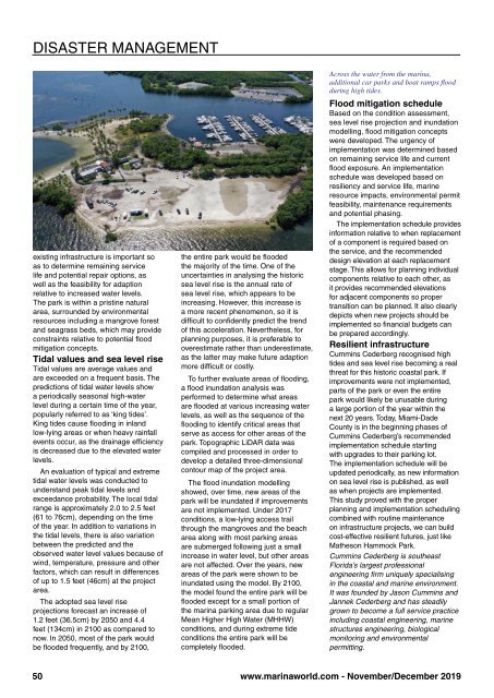
Across the water from the marina,<br />
additional car parks and boat ramps flood<br />
during high tides.<br />
Flood mitigation schedule<br />
Based on the condition assessment,<br />
sea level rise projection and inundation<br />
modelling, flood mitigation concepts<br />
were developed. The urgency of<br />
implementation was determined based<br />
on remaining service life and current<br />
flood exposure. An implementation<br />
schedule was developed based on<br />
resiliency and service life, marine<br />
resource impacts, environmental permit<br />
feasibility, maintenance requirements<br />
and potential phasing.<br />
The implementation schedule provides<br />
information relative to when replacement<br />
of a component is required based on<br />
the service, and the recommended<br />
design elevation at each replacement<br />
stage. This allows for planning individual<br />
components relative to each other, as<br />
it provides recommended elevations<br />
for adjacent components so proper<br />
transition can be planned. It also clearly<br />
depicts when new projects should be<br />
implemented so financial budgets can<br />
be prepared accordingly.<br />
Resilient infrastructure<br />
Cummins Cederberg recognised high<br />
tides and sea level rise becoming a real<br />
threat for this historic coastal park. If<br />
improvements were not implemented,<br />
parts of the park or even the entire<br />
park would likely be unusable during<br />
a large portion of the year within the<br />
next 20 years. Today, Miami-Dade<br />
County is in the beginning phases of<br />
Cummins Cederberg’s recommended<br />
implementation schedule starting<br />
with upgrades to their parking lot.<br />
The implementation schedule will be<br />
updated periodically, as new information<br />
on sea level rise is published, as well<br />
as when projects are implemented.<br />
This study proved with the proper<br />
planning and implementation scheduling<br />
combined with routine maintenance<br />
on infrastructure projects, we can build<br />
cost-effective resilient futures, just like<br />
Matheson Hammock Park.<br />
Cummins Cederberg is southeast<br />
Florida’s largest professional<br />
engineering firm uniquely specialising<br />
in the coastal and marine environment.<br />
It was founded by Jason Cummins and<br />
Jannek Cederberg and has steadily<br />
grown to become a full service practice<br />
including coastal engineering, marine<br />
structures engineering, biological<br />
monitoring and environmental<br />
permitting.<br />
50<br />
www.marinaworld.com - <strong>November</strong>/<strong>December</strong> <strong>2019</strong>