Groveport Messenger - January 29th, 2023

You also want an ePaper? Increase the reach of your titles
YUMPU automatically turns print PDFs into web optimized ePapers that Google loves.
PAGE 10 - GROVEPORT MESSENGER - <strong>January</strong> 29, <strong>2023</strong><br />
<strong>Groveport</strong> history films<br />
Two documentary films on the history of<br />
<strong>Groveport</strong>, produced by the <strong>Groveport</strong><br />
Heritage Society and Midnet Media, are<br />
now available for viewing online on<br />
YouTube.<br />
The films are: “<strong>Groveport</strong>: A Town and<br />
Its People” and “The Story of John S.<br />
Rarey and Cruiser.”<br />
Letters policy<br />
The <strong>Groveport</strong> <strong>Messenger</strong> welcomes letters to<br />
the editor. Letters cannot be libelous. Letters that do<br />
not have a signature, address, and telephone number,<br />
or are signed with a pseudonym, will be rejected.<br />
PLEASE BE BRIEF AND TO THE POINT. The<br />
<strong>Messenger</strong> reserves the right to edit or refuse publication<br />
of any letter for any reason. Opinions<br />
expressed in the letters are not necessarily the<br />
views of the <strong>Messenger</strong>. Mail letters to: <strong>Groveport</strong><br />
<strong>Messenger</strong>, 3500 Sullivant Avenue, Columbus, OH<br />
43204; or by email to southeast@columbusmessenger.com.<br />
Keep tabs on the latest news in<br />
<strong>Groveport</strong> & Madison Township<br />
Look for <strong>Groveport</strong> <strong>Messenger</strong> on<br />
Become a fan!<br />
southeast<br />
<strong>Messenger</strong><br />
(Distribution: 8,000)<br />
Rick Palsgrove ...................................<strong>Groveport</strong> Editor<br />
southeast@columbusmessenger.com<br />
Published every other Sunday by<br />
The Columbus <strong>Messenger</strong> Co.<br />
3500 Sullivant Ave., Columbus, Ohio 43204-1887<br />
(614) 272-5422<br />
The Columbus <strong>Messenger</strong> Co. reserves the right to edit, reject or cancel<br />
any advertisement or editorial copy at any time. The company is not<br />
responsible for checking accuracy of items submitted for publication.<br />
Errors in advertising copy must be called to the attention of the company<br />
after first insertion and prior to a second insertion of the same advertising<br />
copy.<br />
BIRTHDAY • ENGAGEMENT • WEDDING • ANNIVERSARY<br />
• GRADUATION • RETIREMENT<br />
IN MEMORIUM • ARMED FORCES<br />
Say it with an announcement ad in<br />
the <strong>Messenger</strong> and spread the word.<br />
You can download the appropriate form from<br />
our Web site or stop by our office<br />
Monday-Thursday, 8:30 a.m.-5 p.m.<br />
Friday, 8:30 a.m.-2 p.m.<br />
Columbus <strong>Messenger</strong><br />
3500 Sullivant Ave.<br />
614-272-5422<br />
www.columbusmessenger.com<br />
www.columbusmessenger.com<br />
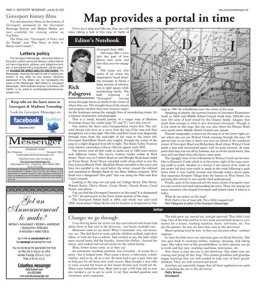
Map provides a portal in time<br />
If you are a map nerd like me, then you will<br />
enjoy taking a look at this map (at right) of<br />
Editor’s Notebook<br />
Rick<br />
Palsgrove<br />
<strong>Groveport</strong> from 1900.<br />
Old maps offer a view<br />
into the past of how<br />
places once were and<br />
how they are ever changing.<br />
Old maps are also<br />
works of art where the<br />
mapmakers’ hand lettering<br />
manages to blend a<br />
large amount of information<br />
in tight spaces while<br />
maintaining clarity. The<br />
bold lettering of<br />
“<strong>Groveport</strong>” curving<br />
across the page leaves no doubt to the viewer of<br />
where they are. The straight lines of the streets<br />
and property borders show how humans organize<br />
the landscape among the squiggly lines of meandering creeks. It’s<br />
a balance of geometry and geography.<br />
This is a small, focused portion of a larger map of Madison<br />
Township (hence the visible large “D” and “I”). Let’s dive into it!<br />
One notices the three main transportation routes first. The railroad<br />
swoops into town on a curve from the top of the map and then<br />
straightens out to the right. The Ohio and Erie Canal runs diagonally<br />
through town from the mid-right of the map to the lower left.<br />
<strong>Groveport</strong> Road/Main Street cuts roughly through the center of the<br />
map at a slight diagonal from left to right. The Scioto Valley Traction<br />
Line (electric interurban railway) did not appear until 1904.<br />
The streets were all dirt roads or paths and in 1900 some streets<br />
took different routes. The town’s western border ended at West<br />
Street. There was no Corbett Road yet and Ebright Road dead ended<br />
on Front Street. Front Street extended north along what is now the<br />
Foor Leisure/Bicycle Path. Blacklick Street extended to the canal and<br />
then ran parallel to the canal before the street crossed the railroad<br />
and connected to Ebright Road by the Mary Dildine property. Wirt<br />
Road was a designated “free pike” that ran along the Ohio and Erie<br />
Canal towpath.<br />
Looking at the map one can pick out College Street, Elm Street,<br />
Walnut Street, Cherry Street, Center Street, Church Street, Canal<br />
Street, and others.<br />
Can you find the <strong>Groveport</strong> Cemetery on this map? It is designated<br />
as “GY,” for graveyard, in the lower center portion of the map.<br />
The <strong>Groveport</strong> School built in 1884, and which was used until<br />
1923, stood along College Street and its location is designated on this<br />
Changes we go through<br />
I was driving down the street one day and noticed each house had<br />
about three or four cars in the driveway - one house, multiple cars.<br />
Memories came to my mind. What I remember was, one house,<br />
one car. The dad drove to work and the children walked, rode their<br />
bikes, or took the bus to school. Dad worked to pay the bills while<br />
mom stayed home, did the laundry, ironed the clothes, cleaned the<br />
house, and cooked and served meals for the whole family.<br />
Then, better times came, or so they say.<br />
An automatic washing machine was invented - of course for a<br />
price - but it helped mom. Then came a dryer, a television, a dishwasher,<br />
and so on, all at a cost. So mom had to get a part time job<br />
to help pay for all these new work savers. Mom bought a new robe<br />
to wear around the house as her house dresses just would not do.<br />
Then came babysitter fees. Mom had to get a full time job so now<br />
she needed a car to get to work. A car that needed gasoline and<br />
insurance, more expenses.<br />
letter<br />
map as “SH” for schoolhouse near the center of the map.<br />
Speaking of schools, the current location of <strong>Groveport</strong> Elementary<br />
(built in 1923) and Middle School Central (built from 1952-56) was<br />
once 103 acres of land owned by the Chaney family. Imagine that<br />
much farm acreage in what is now downtown <strong>Groveport</strong>. Though, it<br />
is not noted on this map, this site was also where the Elmont Hotel<br />
once stood where Middle School Central now stands.<br />
Natural topography is shown on the map as in the lower right corner<br />
where one can see Walnut Creek coursing through the area. Of<br />
special note to see here is there was once an island at the southeast<br />
corner of <strong>Groveport</strong> Road and Richardson Road where Walnut Creek<br />
made a loop and reconnected again with its main channel. At some<br />
point that loop was cut off by humans, but as all the locals know, that<br />
area still can flood when the heavy rains come.<br />
The squiggly lines of two tributaries to Walnut Creek can be seen.<br />
One is Hanstein Creek which is at the center right of the map coursing<br />
north to south. Another is a stream (I am unsure of its name) at<br />
the center left that runs north to south to the creek following a path<br />
down what is now Lesleh Avenue and through today’s green space<br />
that separates Newport Village from the houses on West Street. I’m<br />
guessing this stream is now mostly tiled underground<br />
Finally, gaze at the map and see the many names of property owners<br />
who owned rural land surrounding the town. These are among our<br />
many ancestors who shaped <strong>Groveport</strong> and helped make it what it is<br />
today.<br />
What do you notice on the map?<br />
Well, that’s a lot of map talk. I’m a little mapped out!<br />
Rick Palsgrove is editor of the <strong>Groveport</strong> <strong>Messenger</strong>.<br />
The kids grew up, moved out, and got married. That didn’t last<br />
long. One of the kids and his or her mate moved back home to save<br />
money for a house, washing machine, dryer, television, etc. You<br />
get the picture. So now we have four cars in the driveway!<br />
Mom’s getting tired by now, so they eat out more often - another<br />
expense.<br />
In time the kids move out and mom goes on Social Security. She<br />
also goes back to washing clothes, cooking, cleaning, and taking<br />
naps. She takes care of the grandchildren so their parents can go<br />
to work and buy cars, washing machines, televisions, etc.<br />
Now there is just one car in the driveway. But other cars are<br />
coming and going all day long. This makes grandma and grandpa<br />
happy knowing they are still needed to take care of their grandchildren.<br />
They are still wanted and loved.<br />
And they are especially happy that all their appliances are paid<br />
for, including the car in the driveway!<br />
Patty Brown<br />
<strong>Groveport</strong>