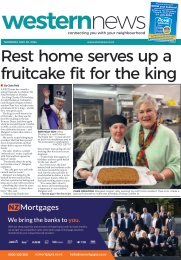
Bay Harbour: April 03, 2024

Create successful ePaper yourself
Turn your PDF publications into a flip-book with our unique Google optimized e-Paper software.
Wednesday <strong>April</strong> 3 <strong>2024</strong> <strong>Bay</strong> <strong>Harbour</strong> News<br />
Latest Canterbury news at starnews.co.nz<br />
NEWS 15<br />
Unpacking the Bridle Path myth<br />
• By JC Betts<br />
IT IS WELL established the first<br />
four ships arrived at Lyttelton<br />
in December 1850, but what<br />
happened next?<br />
The popular belief is the<br />
pioneers headed over the Bridle<br />
Path at once. But did they?<br />
“... Embedded in the soil of<br />
Christchurch, as much a part of<br />
local history as the pilgrims who<br />
had footed it over the Bridle Path<br />
from Lyttelton, the men in top<br />
hats, the women in crinolines, to<br />
found the city.” – Peter Graham,<br />
So Brilliantly Clever, Awa Press<br />
2011<br />
“The Bridle Path was the<br />
first hurdle for the Canterbury<br />
pioneers of 1850 – after three<br />
months at sea, they were finally<br />
delivered at Lyttelton, only to<br />
have to climb up over the Port<br />
Hills to reach their promised<br />
land. Out of condition, in unsuitable<br />
clothing, and burdened with<br />
the luggage that wouldn’t fit on<br />
the pack horses, they trudged up<br />
the steep side of the crater to get<br />
their first view of the Canterbury<br />
Plains and the site of their new<br />
home.” – Pamela Wade, Sunday<br />
Star-Times, June 21, 2020.<br />
So the first thing the settlers<br />
did on disembarking was parade<br />
over the hill, bag and baggage in<br />
hand, to – what?<br />
In 1850, the only building on<br />
the swamp that was to become<br />
Christchurch was a surveyors’<br />
hut – they were desperately trying<br />
to complete a map of the city<br />
before the immigrants’ arrival.<br />
Meanwhile, back in Lyttelton,<br />
the Canterbury Association’s<br />
chief agent John Godley, chief<br />
surveyor Captain Joseph Thomas<br />
and scores of workers had prepared<br />
for the pilgrims’ arrival<br />
more completely than any other<br />
settlement in New Zealand.<br />
They had built four immigration<br />
barracks; all settlers were entitled<br />
to at least two weeks’ accommodation.<br />
In December 1850<br />
the buildings were overcrowded<br />
with the 750 odd arrivals, so the<br />
younger men camped or built<br />
temporary huts nearby. Many<br />
of the cabin passengers – those<br />
who had already purchased land,<br />
known as ‘colonists’, preferred to<br />
stay on board.<br />
There were already 60 temporary<br />
houses and two hotels<br />
in port. Captain Thomas had<br />
supervised the building of a<br />
wharf, the chief agent’s house, an<br />
office, a store, a boathouse, and<br />
the start of the Sumner Rd over<br />
Tapuaeharuru Evans Pass. Then<br />
the money ran out.<br />
The Bridle Path was built as a<br />
stopgap measure.<br />
Charlotte Godley wrote in<br />
November 1850: “Since the<br />
money was lent by the Governor<br />
for carrying on the works . .<br />
. about 300 pounds has been<br />
devoted to making a bridle path<br />
. . . which is about two miles<br />
shorter than the line of the road,<br />
but it will only be meant for<br />
horses. When we went up there<br />
was still a bit at the top where<br />
no one can ride; man and horse<br />
must climb over rough stones<br />
and rocks, and on the other<br />
side the descent is steep enough<br />
to make most people prefer<br />
walking, too . . .” – Charlotte<br />
Godley, Letters from Early<br />
New Zealand, Whitcombe and<br />
Tombs, 1851.<br />
As Lyttelton was the only town<br />
in Canterbury, it was where the<br />
settlers stayed. Most of them<br />
would have climbed to the top of<br />
the hill to look at the view – and<br />
then gone straight back down to<br />
the port. Those who continued<br />
over to ‘the plains’ were<br />
predominantly the colonists<br />
who had purchased land, keen<br />
to identify the best locations, but<br />
nobody could settle permanently<br />
until the sections had been<br />
allocated. This happened<br />
in late February 1851, after<br />
Christchurch’s first building, the<br />
land office, was completed.<br />
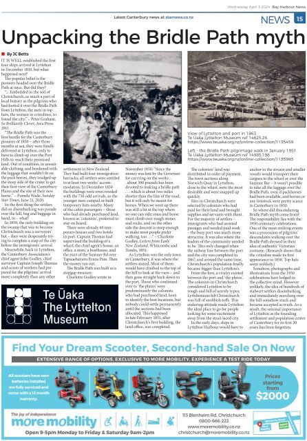
View of Lyttelton and port in 1863<br />
Te Ūaka Lyttelton Museum ref 14625.26<br />
https://www.teuaka.org.nz/online-collection/1135459<br />
Left - the Bridle Path pilgrimage walk in January 1951<br />
Te Ūaka Lyttelton Museum ref 14985.198<br />
https://www.teuaka.org.nz/online-collection/1135993<br />
The colonists’ land was<br />
distributed in order of payment.<br />
The town sections along<br />
Norwich Quay in Lyttelton,<br />
close to the wharf, were the most<br />
desirable and were snapped up<br />
quickly.<br />
Sites in Christchurch were<br />
selected by colonists who had<br />
paid for their land and brought<br />
supplies and servants with them.<br />
For the majority of settlers –<br />
immigrants who had assisted<br />
passages and needed paid work<br />
– the busy port was much more<br />
attractive. It was also where the<br />
leaders of the community needed<br />
to be. This only changed when<br />
the railway line between the port<br />
and the city was completed in<br />
1867, and around the same time,<br />
Christchurch’s population finally<br />
became bigger than Lyttelton’s.<br />
From the first, a rivalry existed<br />
between the port and ‘the plains’.<br />
The colonists in Christchurch<br />
considered Lyttelton to be<br />
rough and full of unruly types;<br />
Lytteltonians felt Christchurch<br />
was full of snobbish toffs. This<br />
enduring attitude made Lyttelton<br />
the ideal place to go for people<br />
looking for some excitement<br />
away from the strait-laced city.<br />
In the early days, ships in<br />
Lyttelton <strong>Harbour</strong> would have to<br />
anchor in the stream and smaller<br />
vessels would transport their<br />
cargoes to the wharf or over the<br />
Sumner Bar – it wasn’t possible<br />
to take all the luggage over the<br />
Bridle Path, even if packhorses<br />
had been available, and horses or<br />
any livestock were pretty scarce<br />
in Canterbury in 1850.<br />
So where did this enduring<br />
Bridle Path myth come from?<br />
The responsibility lies with the<br />
1950 centenary celebrations.<br />
One of the most striking events<br />
was a procession of pilgrims’<br />
descendants walking over the<br />
Bridle Path dressed in their<br />
idea of authentic Victorian<br />
costume. (Research shows that<br />
the crinoline made its first<br />
appearance in 1858. Top hats<br />
seem unlikely.)<br />
Somehow, photographs and<br />
illustrations from the 1950<br />
celebrations have lodged in<br />
the collective mind. However<br />
unlikely, the idea of hundreds of<br />
stalwart settlers disembarking<br />
and immediately marching over<br />
the hill somehow stuck and<br />
became accepted as truth. As a<br />
result, the seminal importance<br />
of Lyttelton as the founding<br />
settlement and population centre<br />
of Canterbury for its first 20<br />
years has been forgotten.<br />
Find Your Dream Scooter, Second-hand Sale On Now<br />
EXTENSIVE RANGE OF OPTIONS, EXCLUSIVE TO MORE MOBILITY, EXPERIENCE A TEST RIDE TODAY<br />
All scooters have new<br />
batteries installed<br />
are fully serviced and<br />
come with a 12 month<br />
warranty.<br />
Prices<br />
starting<br />
from<br />
$2000<br />
Open 9-5pm Monday to Friday & Saturday 9am-2pm<br />
113 Blenheim Rd, Christchurch<br />
0800-666-222<br />
www.moremobility.co.nz<br />
christchurch@moremobility.co.nz<br />
Blehheim Road<br />
More<br />
Mobility<br />
Splash<br />
N Dash<br />
Clarence Street