SOLWEIG 1.0 – Modelling spatial variations of 3D radiant fluxes and ...
SOLWEIG 1.0 – Modelling spatial variations of 3D radiant fluxes and ...
SOLWEIG 1.0 – Modelling spatial variations of 3D radiant fluxes and ...

Create successful ePaper yourself
Turn your PDF publications into a flip-book with our unique Google optimized e-Paper software.
698 Int J Biometeorol (2008) 52:697<strong>–</strong>713<br />
sky the upper hemisphere, both with an angle factor <strong>of</strong> 0.5<br />
(e.g. Jendritzky et al. 1990; Pickup<strong>and</strong>deDear1999).<br />
Although easier to use, this method is only reliable for<br />
unobstructed open spaces, <strong>and</strong> obstruction effects should<br />
be added using sky view factors.<br />
Over the years, several different s<strong>of</strong>tware have been<br />
developed to simulate Tmrt in outdoor urban settings.<br />
TOWNSCOPE (Teller <strong>and</strong> Azar 2001) is a CAD-based<br />
s<strong>of</strong>tware which, among other things, simulates <strong>spatial</strong><br />
<strong>variations</strong> <strong>of</strong> solar access <strong>and</strong> Tmrt in complex urban<br />
environments. Thermal comfort can only be calculated on<br />
a daily, monthly or annual basis <strong>and</strong>, since vector data are<br />
utilised, the <strong>spatial</strong> extension is limited. The RayMan<br />
s<strong>of</strong>tware (Matzarakis 2000; Matzarakis et al. 2000, 2007)<br />
is a tool which, along with Tmrt, simulates different thermal<br />
indices. RayMan is a stationary model <strong>and</strong> can be run on<br />
very few input meteorological parameters. RayMan is very<br />
user-friendly <strong>and</strong> thus a popular tool for researchers, urban<br />
planners <strong>and</strong> practitioners. Although commonly used,<br />
RayMan has some principal shortcomings regarding the<br />
calculation <strong>of</strong> the three-dimensional radiation flux densities<br />
<strong>and</strong> surface temperatures <strong>and</strong>, consequently, the resulting<br />
Tmrt (Thorsson et al. 2007). The three-dimensional ENVImet<br />
model (Bruse 1999, 2006) simulates radiation <strong>fluxes</strong>,<br />
temperature, wind flow, turbulence <strong>and</strong> humidity, as well as<br />
Tmrt with high <strong>spatial</strong> <strong>and</strong> temporal resolution. The model is<br />
grid-based. Because <strong>of</strong> its complexity, the model’s domain<br />
size is restricted to 250×250×25 grids. It can be run on a<br />
regular PC. Like the other models mentioned above, ENVImet<br />
calculates Tmrt according to Fanger (1972); the<br />
surrounding environment is divided into building surfaces,<br />
the free atmosphere (sky) <strong>and</strong> the ground surface for which<br />
the direct, diffuse <strong>and</strong> diffusely reflected shortwave <strong>and</strong> the<br />
total longwave radiation components are taken into account.<br />
At street level, the total longwave radiation <strong>fluxes</strong><br />
are assumed to originate from the upper hemisphere (sky<br />
<strong>and</strong> buildings) <strong>and</strong> from the ground (lower hemisphere).<br />
ENVI-met is still under development. To date, the model<br />
has only been evaluated with respect to Tmrt for an east<strong>–</strong>west<br />
oriented urban canyon (H/W=1) in Freiburg, Germany,<br />
during a hot summer’s day (Ali Toudert 2005). The<br />
evaluation showed good agreement between simulated<br />
shortwave radiation <strong>fluxes</strong> <strong>and</strong> field data. However, the<br />
simulated longwave radiation <strong>fluxes</strong> revealed discrepancies<br />
with the field data by up to 50 Wm −2 , which played the main<br />
role in the differences observed in T mrt, (<strong>–</strong>8°C in daytime)<br />
(Ali Toudert 2005).<br />
In this paper, the development <strong>of</strong> a new radiation model,<br />
<strong>SOLWEIG</strong> <strong>1.0</strong> (solar <strong>and</strong> longwave environmental irradiance<br />
geometry-model), which simulates three-dimensional<br />
daytime radiation <strong>fluxes</strong> <strong>and</strong> Tmrt in complex urban settings<br />
is presented. The first part <strong>of</strong> the paper presents the features<br />
<strong>of</strong> the <strong>SOLWEIG</strong> <strong>1.0</strong> model <strong>and</strong> is followed by an<br />
evaluation <strong>of</strong> the model using three-dimensional integral<br />
radiation measurements.<br />
Materials <strong>and</strong> methods<br />
Model structure<br />
The framework theory for Tmrt calculations used in this<br />
study is based on the measuring procedure proposed by<br />
Höppe (1992), in which each <strong>of</strong> the six longwave <strong>and</strong><br />
shortwave radiation <strong>fluxes</strong> (upward, downward <strong>and</strong> from<br />
the four cardinal points) is considered. The meteorological<br />
input parameters are direct, diffuse <strong>and</strong> global shortwave<br />
radiation, air temperature <strong>and</strong> relative humidity. Spatial<br />
<strong>variations</strong> <strong>of</strong> urban geometry are represented by a highresolution<br />
urban digital elevation model (DEM) covering<br />
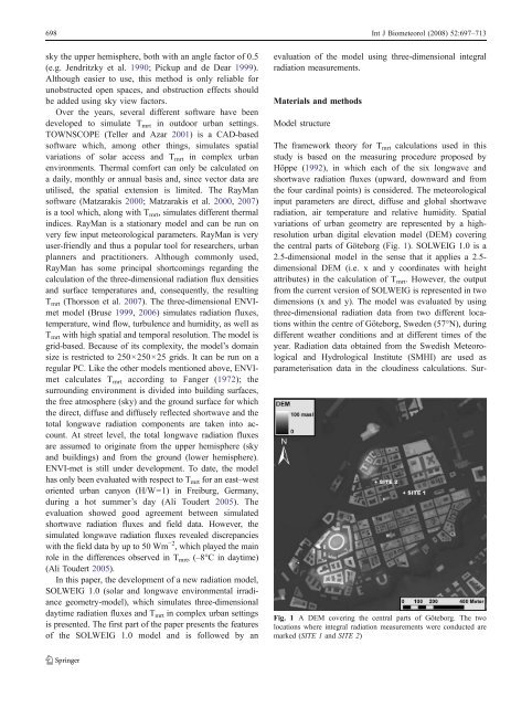
the central parts <strong>of</strong> Göteborg (Fig. 1). <strong>SOLWEIG</strong> <strong>1.0</strong> is a<br />
2.5-dimensional model in the sense that it applies a 2.5dimensional<br />
DEM (i.e. x <strong>and</strong> y coordinates with height<br />
attributes) in the calculation <strong>of</strong> Tmrt. However, the output<br />
from the current version <strong>of</strong> <strong>SOLWEIG</strong> is represented in two<br />
dimensions (x <strong>and</strong> y). The model was evaluated by using<br />
three-dimensional radiation data from two different locations<br />
within the centre <strong>of</strong> Göteborg, Sweden (57°N), during<br />
different weather conditions <strong>and</strong> at different times <strong>of</strong> the<br />
year. Radiation data obtained from the Swedish Meteorological<br />
<strong>and</strong> Hydrological Institute (SMHI) are used as<br />
parameterisation data in the cloudiness calculations. Sur-<br />
Fig. 1 A DEM covering the central parts <strong>of</strong> Göteborg. The two<br />
locations where integral radiation measurements were conducted are<br />
marked (SITE 1 <strong>and</strong> SITE 2)