SOLWEIG 1.0 – Modelling spatial variations of 3D radiant fluxes and ...
SOLWEIG 1.0 – Modelling spatial variations of 3D radiant fluxes and ...
SOLWEIG 1.0 – Modelling spatial variations of 3D radiant fluxes and ...

Create successful ePaper yourself
Turn your PDF publications into a flip-book with our unique Google optimized e-Paper software.
702 Int J Biometeorol (2008) 52:697<strong>–</strong>713<br />
estimated. This was especially evident in the mornings <strong>and</strong><br />
evenings throughout the annual cycle <strong>and</strong> was particularly<br />
pronounced during the winter season. The underestimation<br />
was shown to be as much as 50% during the very first <strong>and</strong><br />
very last hour <strong>of</strong> daylight. Thus a relationship was<br />
established between CI during clear days <strong>and</strong> the altitude<br />
<strong>of</strong> the sun. Clear days were objectively selected by fitting a<br />
dome-shaped polynomial <strong>of</strong> the second degree with a<br />
determination coefficient (R 2 ) greater than 0.98. The entire<br />
dataset (1986<strong>–</strong>2005) obtained from the SMHI station was<br />
used. A total <strong>of</strong> 96 days was derived from the dataset. The<br />
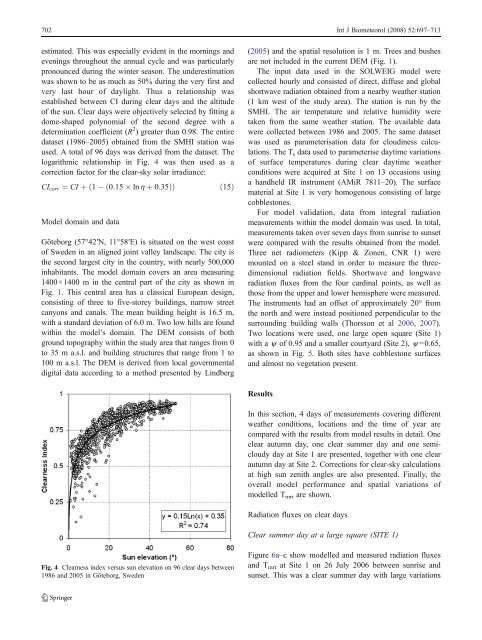
logarithmic relationship in Fig. 4 was then used as a<br />
correction factor for the clear-sky solar irradiance:<br />
CIcorr ¼ CI þ ð1ð0:15 ln h þ 0:35ÞÞ<br />
ð15Þ<br />
Model domain <strong>and</strong> data<br />
Göteborg (57°42′N, 11°58′E) is situated on the west coast<br />
<strong>of</strong> Sweden in an aligned joint valley l<strong>and</strong>scape. The city is<br />
the second largest city in the country, with nearly 500,000<br />
inhabitants. The model domain covers an area measuring<br />
1400×1400 m in the central part <strong>of</strong> the city as shown in<br />
Fig. 1. This central area has a classical European design,<br />
consisting <strong>of</strong> three to five-storey buildings, narrow street<br />
canyons <strong>and</strong> canals. The mean building height is 16.5 m,<br />
with a st<strong>and</strong>ard deviation <strong>of</strong> 6.0 m. Two low hills are found<br />
within the model’s domain. The DEM consists <strong>of</strong> both<br />
ground topography within the study area that ranges from 0<br />
to 35 m a.s.l. <strong>and</strong> building structures that range from 1 to<br />
100 m a.s.l. The DEM is derived from local governmental<br />
digital data according to a method presented by Lindberg<br />
Fig. 4 Clearness index versus sun elevation on 96 clear days between<br />
1986 <strong>and</strong> 2005 in Göteborg, Sweden<br />
(2005) <strong>and</strong> the <strong>spatial</strong> resolution is 1 m. Trees <strong>and</strong> bushes<br />
are not included in the current DEM (Fig. 1).<br />
The input data used in the <strong>SOLWEIG</strong> model were<br />
collected hourly <strong>and</strong> consisted <strong>of</strong> direct, diffuse <strong>and</strong> global<br />
shortwave radiation obtained from a nearby weather station<br />
(1 km west <strong>of</strong> the study area). The station is run by the<br />
SMHI. The air temperature <strong>and</strong> relative humidity were<br />
taken from the same weather station. The available data<br />
were collected between 1986 <strong>and</strong> 2005. The same dataset<br />
was used as parameterisation data for cloudiness calculations.<br />
The T s data used to parameterise daytime <strong>variations</strong><br />
<strong>of</strong> surface temperatures during clear daytime weather<br />
conditions were acquired at Site 1 on 13 occasions using<br />
a h<strong>and</strong>held IR instrument (AMiR 7811<strong>–</strong>20). The surface<br />
material at Site 1 is very homogenous consisting <strong>of</strong> large<br />
cobblestones.<br />
For model validation, data from integral radiation<br />
measurements within the model domain was used. In total,<br />
measurements taken over seven days from sunrise to sunset<br />
were compared with the results obtained from the model.<br />
Three net radiometers (Kipp & Zonen, CNR 1) were<br />
mounted on a steel st<strong>and</strong> in order to measure the threedimensional<br />
radiation fields. Shortwave <strong>and</strong> longwave<br />
radiation <strong>fluxes</strong> from the four cardinal points, as well as<br />
those from the upper <strong>and</strong> lower hemisphere were measured.<br />
The instruments had an <strong>of</strong>fset <strong>of</strong> approximately 20° from<br />
the north <strong>and</strong> were instead positioned perpendicular to the<br />
surrounding building walls (Thorsson et al 2006, 2007).<br />
Two locations were used, one large open square (Site 1)<br />
with a y <strong>of</strong> 0.95 <strong>and</strong> a smaller courtyard (Site 2), y =0.65,<br />
as shown in Fig. 5. Both sites have cobblestone surfaces<br />
<strong>and</strong> almost no vegetation present.<br />
Results<br />
In this section, 4 days <strong>of</strong> measurements covering different<br />
weather conditions, locations <strong>and</strong> the time <strong>of</strong> year are<br />
compared with the results from model results in detail. One<br />
clear autumn day, one clear summer day <strong>and</strong> one semicloudy<br />
day at Site 1 are presented, together with one clear<br />
autumn day at Site 2. Corrections for clear-sky calculations<br />
at high sun zenith angles are also presented. Finally, the<br />
overall model performance <strong>and</strong> <strong>spatial</strong> <strong>variations</strong> <strong>of</strong><br />
modelled Tmrt are shown.<br />
Radiation <strong>fluxes</strong> on clear days<br />
Clear summer day at a large square (SITE 1)<br />
Figure 6a<strong>–</strong>c show modelled <strong>and</strong> measured radiation <strong>fluxes</strong><br />
<strong>and</strong> T mrt at Site 1 on 26 July 2006 between sunrise <strong>and</strong><br />
sunset. This was a clear summer day with large <strong>variations</strong>