November 2010 - BC Hydro
November 2010 - BC Hydro
November 2010 - BC Hydro
You also want an ePaper? Increase the reach of your titles
YUMPU automatically turns print PDFs into web optimized ePapers that Google loves.
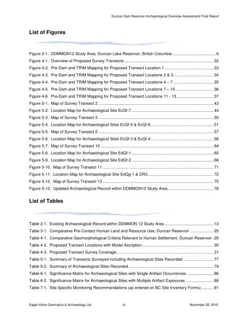
List of Figures<br />
Duncan Dam Reservoir Archaeological Overview Assessment Final Report<br />
Figure 2-1. DDMMON12 Study Area, Duncan Lake Reservoir, British Columbia ....................................... 6<br />
Figure 4-1. Overview of Proposed Survey Transects ................................................................................ 32<br />
Figure 4-2. Pre-Dam and TRIM Mapping for Proposed Transect Location 1 ............................................ 33<br />
Figure 4-3. Pre-Dam and TRIM Mapping for Proposed Transect Locations 2 & 3 .................................... 34<br />
Figure 4-4. Pre-Dam and TRIM Mapping for Proposed Transect Locations 4 – 7 .................................... 35<br />
Figure 4-5. Pre-Dam and TRIM Mapping for Proposed Transect Locations 7 – 10 .................................. 36<br />
Figure 4-6. Pre-Dam and TRIM Mapping for Proposed Transect Locations 11 - 13 ................................. 37<br />
Figure 5-1. Map of Survey Transect 2 ....................................................................................................... 43<br />
Figure 5-2. Location Map for Archaeological Site EcQf-7 .......................................................................... 44<br />
Figure 5-3. Map of Survey Transect 3 ....................................................................................................... 50<br />
Figure 5-4. Location Map for Archaeological Sites EcQf-5 & EcQf-6 ........................................................ 51<br />
Figure 5-5. Map of Survey Transect 5 ....................................................................................................... 57<br />
Figure 5-6. Location Map for Archaeological Sites EcQf-3 & EcQf-4 ........................................................ 58<br />
Figure 5-7. Map of Survey Transect 10 ..................................................................................................... 64<br />
Figure 5-8. Location Map for Archaeological Site EdQf-1 ......................................................................... 65<br />
Figure 5-9. Location Map for Archaeological Site EdQf-2 ......................................................................... 66<br />
Figure 5-10. Map of Survey Transect 11 ................................................................................................... 71<br />
Figure 5-11. Location Map for Archaeological Site EdQg-1 & DR3 ........................................................... 72<br />
Figure 5-12. Map of Survey Transect 13 ................................................................................................... 75<br />
Figure 5-13. Updated Archaeological Record within DDMMON12 Study Area ......................................... 78<br />
List of Tables<br />
Table 2-1. Existing Archaeological Record within DDMMON 12 Study Area ............................................ 13<br />
Table 3-1. Comparative Pre-Contact Human Land and Resource Use, Duncan Reservoir ..................... 25<br />
Table 4-1. Comparative Geomorphological Criteria Relevant to Human Settlement, Duncan Reservoir . 29<br />
Table 4-2. Proposed Transect Locations with Model Ascription ................................................................ 30<br />
Table 4-3. Proposed Transect Survey Coverage....................................................................................... 31<br />
Table 5-1. Summary of Transects Surveyed including Archaeological Sites Recorded ........................... 77<br />
Table 5-2. Summary of Archaeological Sites Recorded ............................................................................ 79<br />
Table 6-1. Significance Matrix for Archaeological Sites with Single Artifact Occurrences ........................ 86<br />
Table 6-2. Significance Matrix for Archaeological Sites with Multiple Artifact Exposures ......................... 88<br />
Table 7-1. Site Specific Monitoring Recommendations (as entered on <strong>BC</strong> Site Inventory Forms) ........... 91<br />
Eagle Vision Geomatics & Archaeology Ltd. vii <strong>November</strong> 28, <strong>2010</strong>


