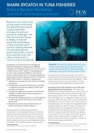
The Marine Environment of the Pitcairn Islands - Pew Environment ...
The Marine Environment of the Pitcairn Islands - Pew Environment ...
The Marine Environment of the Pitcairn Islands - Pew Environment ...

You also want an ePaper? Increase the reach of your titles
YUMPU automatically turns print PDFs into web optimized ePapers that Google loves.
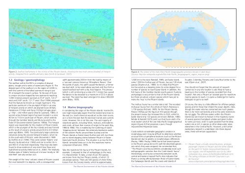
Figure 3. Seafloor bathymetry in <strong>the</strong> vicinity <strong>of</strong> <strong>the</strong> <strong>Pitcairn</strong> <strong>Islands</strong>, showing <strong>the</strong> two main zones (shaded) <strong>of</strong> hotspot<br />
activity. (Adapted from satellite altimetry data [Smith & Sandwell, 1997]).<br />
1.3 Geology / geomorphology<br />
<strong>The</strong> seafloor within <strong>the</strong> EEZ is a complex <strong>of</strong> abyssal<br />
plains, troughs and a series <strong>of</strong> seamounts (Figure 3). <strong>The</strong><br />
deepest part <strong>of</strong> <strong>the</strong> seafloor is in <strong>the</strong> region <strong>of</strong> 4,000 m,<br />
with <strong>the</strong> summit <strong>of</strong> <strong>the</strong> tallest seamount rising to just<br />
55 m beneath <strong>the</strong> ocean’s surface. To <strong>the</strong> east <strong>of</strong> Ducie<br />
is a major structure topped by two seamounts reaching<br />
1,000 m below present sea level at 25.0° south, 122.2°<br />
west and 24.8° south, 121.7° west. Okal (1984) proposed<br />
that this feature be known as Crough Seamount. This<br />
particular seamount is <strong>the</strong> youngest (4 Myr) in an area<br />
<strong>of</strong> hotspot activity on which are aligned Ducie (8 Myr),<br />
Henderson (13 Myr) and Oeno (16 Myr) [all ages given<br />
± 1 Myr – one million years] (Okal & Cazenave, 1985). A<br />
second active hotspot region has been located in a zone<br />
40 km to 110 km south-east <strong>of</strong> <strong>Pitcairn</strong>, which extends<br />
through <strong>the</strong> Gambier <strong>Islands</strong> and Mururoa atoll to <strong>the</strong><br />
Duke <strong>of</strong> Gloucester <strong>Islands</strong> (Spencer, 1989a). This hotspot<br />
region was responsible for <strong>the</strong> creation <strong>of</strong> <strong>Pitcairn</strong> Island,<br />
which is <strong>the</strong> youngest <strong>of</strong> <strong>the</strong> four islands and was formed<br />
as <strong>the</strong> result <strong>of</strong> volcanic activity around 0.8 to 0.9 million<br />
years ago (Blake, 1995). Two particularly large submarine<br />
volcanoes along this second hotspot lineation, which lie<br />
to <strong>the</strong> south-east <strong>of</strong> <strong>Pitcairn</strong>, were discovered in 1989<br />
by St<strong>of</strong>fers et al. (1990). <strong>The</strong>y were named ‘Adams’ and<br />
‘Bounty’ by Binard et al. (1992) and rise to within 55 m<br />
and 450 m <strong>of</strong> sea level respectively. <strong>The</strong>y have also been<br />
found to show evidence <strong>of</strong> very recent lava flows and<br />
hydro<strong>the</strong>rmal activity (Hekinian et al., 2003). <strong>The</strong> relatively<br />
shallow apex <strong>of</strong> Adams Seamount is known locally as ’40mile<br />
Reef’ (see also section 4.2).<br />
<strong>The</strong> weight <strong>of</strong> <strong>the</strong> ‘new’ volcanic island <strong>of</strong> <strong>Pitcairn</strong> caused<br />
<strong>the</strong> crust beneath it to depress, with a consequential<br />
4<br />
uplift approximately 200 km from <strong>the</strong> load by means <strong>of</strong><br />
a ‘see-saw’ process known as ‘lithospheric flexure’. Over<br />
thousands <strong>of</strong> years, this uplift caused Henderson, a former<br />
sea-level atoll, to be raised above sea level and thus form a<br />
raised fossilised reef with a dry, fossil lagoon. This process<br />
(which is still continuing at a rate <strong>of</strong> 0.1 mm/yr) has caused<br />
Henderson to be elevated to a maximum <strong>of</strong> 33.5 m above<br />
sea level. <strong>The</strong> island has been emergent for about 380,000<br />
years (Blake, 1995).<br />
1.4 <strong>Marine</strong> biogeography<br />
In considering <strong>the</strong> origin <strong>of</strong> <strong>the</strong> <strong>Pitcairn</strong> <strong>Islands</strong>’ marine life,<br />
one might reasonably expect that <strong>the</strong> nearest land mass to<br />
<strong>the</strong> east (i.e. South America) would act as <strong>the</strong> main source,<br />
as it is from <strong>the</strong> east that <strong>the</strong> dominant winds and currents<br />
come. However, this is not <strong>the</strong> case. <strong>The</strong> vast majority <strong>of</strong><br />
nearshore species, including fishes, molluscs, echinoderms<br />
and corals, all have <strong>the</strong>ir sources <strong>of</strong> origin to <strong>the</strong> west (Kay,<br />
1980 & 1984). This is enabled by <strong>the</strong> scattering <strong>of</strong> island<br />
‘stepping stones’ between <strong>the</strong> extremely biodiverse waters<br />
<strong>of</strong> <strong>the</strong> western Pacific (around New Guinea) and <strong>the</strong><br />
<strong>Pitcairn</strong> <strong>Islands</strong> or Easter Island (fur<strong>the</strong>r east still), but <strong>the</strong>re<br />
are no island stepping stones between <strong>Pitcairn</strong> or Easter<br />
Island and South America. This situation is as true for <strong>the</strong><br />
<strong>Islands</strong>’ terrestrial biota as it is for <strong>the</strong> nearshore marine<br />
component (Diamond, 1995).<br />
Take <strong>the</strong> nearshore fish fauna <strong>of</strong> <strong>the</strong> <strong>Pitcairn</strong> <strong>Islands</strong>, for<br />
example. Compared to that <strong>of</strong> archipelagos to <strong>the</strong> west,<br />
it is impoverished. To date, a total <strong>of</strong> just 352 species<br />
are known from <strong>the</strong> four <strong>Pitcairn</strong> islands, <strong>of</strong> which 13<br />
are pelagic species. <strong>The</strong>re are 593 species <strong>of</strong> shore fishes<br />
known from <strong>the</strong> Society <strong>Islands</strong>, which lie approximately<br />
Figure 4. <strong>The</strong> extent <strong>of</strong> <strong>the</strong> Indo-West Pacific biogeographic province (shown in dark blue).<br />
(Source: http://en.wikipedia.org/wiki/File:Indo-Pacific_biogeographic_region_map-en.png)<br />
1,500 km to <strong>the</strong> west (Randall, 1985), yet Easter Island,<br />
some 1,900 km fur<strong>the</strong>r east <strong>of</strong> <strong>Pitcairn</strong>, has just 126 shore<br />
species (Disalvo et al., 1988). So it is likely that <strong>Pitcairn</strong><br />
too has acted as a stepping stone (to some degree) for a<br />
number <strong>of</strong> species to reach Easter Island. In addition, <strong>the</strong><br />
fish fauna <strong>of</strong> <strong>the</strong> Gambier <strong>Islands</strong> (south-eastern Tuamotu<br />
archipelago) is very similar to that <strong>of</strong> <strong>the</strong> <strong>Pitcairn</strong> <strong>Islands</strong><br />
but <strong>the</strong>re are about a dozen species which have yet to<br />
make <strong>the</strong> ‘hop’ to <strong>the</strong> <strong>Pitcairn</strong> <strong>Islands</strong>.<br />
<strong>The</strong> mollusc fauna has a similar tale to tell. <strong>The</strong> recorded<br />
molluscan fauna from <strong>the</strong> whole <strong>of</strong> French Polynesia is<br />
1,159 species (Richard, 1985); for <strong>the</strong> <strong>Pitcairn</strong> <strong>Islands</strong>,<br />
Preece (1995a) put <strong>the</strong> figure at 419 species (though<br />
<strong>the</strong> present review has increased this to 502), while for<br />
Easter Island only 133 species are known (Rehder, 1980).<br />
Rehder & Randall (1975) point out that Ducie atoll is <strong>the</strong><br />
most eastern atoll <strong>of</strong> <strong>the</strong> vast Indo-Pacific biogeographical<br />
region (Figure 4) that possesses a pure, though<br />
impoverished Polynesian biota.<br />
Corals exhibit considerable geographic variation in<br />
morphology and it may be difficult to determine whe<strong>the</strong>r<br />
unusual forms at peripheral locations (such as <strong>the</strong> <strong>Pitcairn</strong><br />
<strong>Islands</strong>) are due to genetic or ecophenotypic differences<br />
(Paulay, 1989). Paulay (1989) found that several species<br />
in <strong>the</strong> <strong>Pitcairn</strong> group did not fit well <strong>the</strong> described species<br />
into which <strong>the</strong>y were assigned. He commented that,<br />
“<strong>The</strong> <strong>Pitcairn</strong> coral fauna exhibits considerably more such<br />
odd geographic variation than <strong>the</strong> Cook <strong>Islands</strong>’ fauna”.<br />
Interestingly, coral fauna connectivity between south,<br />
central and eastern tropical Pacific sites indicates that<br />
<strong>the</strong>re is a strong affinity between those <strong>of</strong> Easter Island,<br />
<strong>the</strong> Galapagos <strong>Islands</strong> and <strong>the</strong> coasts and islands <strong>of</strong><br />
Ecuador, Colombia, Panama and Costa Rica fur<strong>the</strong>r to <strong>the</strong><br />
east (Glynn et al., 2007).<br />
One should not forget that <strong>the</strong> amount <strong>of</strong> research<br />
carried out in any one location is also likely to have a<br />
bearing on <strong>the</strong> number <strong>of</strong> species recorded from that<br />
location. Not only is <strong>Pitcairn</strong> an isolated spot for nearshore<br />
marine species to reach, it is quite a challenge for marine<br />
biologists to get to as well!<br />
Of course, <strong>the</strong> story is a little different for <strong>of</strong>fshore pelagic<br />
species and for those that inhabit <strong>the</strong> ocean depths. Here,<br />
though <strong>the</strong> water volumes concerned are much greater,<br />
<strong>the</strong>re is far more connectivity and so <strong>the</strong> same restrictions<br />
do not apply. <strong>The</strong> <strong>of</strong>fshore waters within <strong>the</strong> <strong>Pitcairn</strong><br />
<strong>Islands</strong> EEZ are known to feature in <strong>the</strong> migratory routes<br />
<strong>of</strong> several species (humpback whales and green turtles<br />
to name just two), and it is quite possible that <strong>the</strong> deep<br />
waters are as rich in species as o<strong>the</strong>r deep-water areas<br />
elsewhere in <strong>the</strong> Central Pacific. However, until fur<strong>the</strong>r<br />
exploratory research is undertaken into <strong>the</strong>se abyssal<br />
areas, <strong>the</strong>se will remain suppositions.<br />
11. <strong>Pitcairn</strong> Travel, a locally owned business, arranges<br />
passenger charters to <strong>Pitcairn</strong> and <strong>the</strong> o<strong>the</strong>r islands<br />
on <strong>the</strong> yacht SV Xplore (www.pitcairntravel.pn).<br />
Less regular, one-<strong>of</strong>f expeditions are run by o<strong>the</strong>r<br />
companies (e.g. www.uncharteredworldtravel.com).<br />
12. <strong>The</strong> sailing schedule <strong>of</strong> <strong>the</strong> MV Claymore II can<br />
be found at:<br />
www.visitpitcairn.pn/visitpitcairn/shipping/index.html<br />
<strong>The</strong> <strong>Marine</strong> <strong>Environment</strong> <strong>of</strong> <strong>the</strong> <strong>Pitcairn</strong> <strong>Islands</strong> <strong>The</strong> <strong>Marine</strong> <strong>Environment</strong> <strong>of</strong> <strong>the</strong> <strong>Pitcairn</strong> <strong>Islands</strong><br />
5