The Marine Environment of the Pitcairn Islands - Pew Environment ...
The Marine Environment of the Pitcairn Islands - Pew Environment ...
The Marine Environment of the Pitcairn Islands - Pew Environment ...

You also want an ePaper? Increase the reach of your titles
YUMPU automatically turns print PDFs into web optimized ePapers that Google loves.
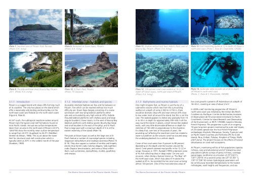
Plate 7. Sea-level view <strong>of</strong> <strong>Pitcairn</strong> from <strong>the</strong> east.<br />
(Photo: R.A. Irving)<br />
Plate 8. <strong>The</strong> jetty and boat shed, Bounty Bay, <strong>Pitcairn</strong><br />
2011. (Photo: R.A. Irving)<br />
3.1.1 Introduction<br />
<strong>Pitcairn</strong> is a rugged island with steep cliffs forming much<br />
<strong>of</strong> its coastline. <strong>The</strong> only two places on <strong>the</strong> island which<br />
<strong>of</strong>fer a reasonably safe landing are Bounty Bay (on <strong>the</strong><br />
north-east coast) and Tedside (on <strong>the</strong> north-west coast)<br />
(Figure 6; Plate 8).<br />
At 24° south, <strong>the</strong> subtropical nearshore waters around<br />
<strong>Pitcairn</strong> lack <strong>the</strong> typical coral reef formations found on<br />
most Pacific islands. Annual sea surface temperatures<br />
taken from an area to <strong>the</strong> north-east <strong>of</strong> <strong>Pitcairn</strong> (23.5°S,<br />
128.0°W) show <strong>the</strong> monthly mean surface temperature<br />
to range from 22.5°C (Aug/Sept) to 26.3°C (Feb/Mar)<br />
(Streten & Zillman, 1984). This is just above <strong>the</strong> lower<br />
limit for structural coral reef construction which is<br />
typically taken as 20°C in <strong>the</strong> coldest month <strong>of</strong> <strong>the</strong> year<br />
(Stoddart, 1969).<br />
Plate 9. Rockpools at Down Isaacs, <strong>Pitcairn</strong>.<br />
(Photo: R.A. Irving)<br />
Plate 10. St Paul’s Pool, <strong>Pitcairn</strong>.<br />
(Photo: T.P. Dawson)<br />
3.1.2 Intertidal zone – habitats and species<br />
Accessible intertidal habitats are few and far between on<br />
<strong>Pitcairn</strong>. Five which can be reached without too much<br />
difficulty are: Down Rope (largely consisting <strong>of</strong> a coarse<br />
sand beach with low-lying bedrock platforms ei<strong>the</strong>r<br />
side and surrounded by very high vertical cliffs); Tedside<br />
(fissured bedrock platforms with shallow pools and large<br />
angular boulders); Down Isaacs, to <strong>the</strong> west <strong>of</strong> Bounty Bay<br />
(bedrock platforms with shallow pools); Bounty Bay (large<br />
and small boulders to <strong>the</strong> east <strong>of</strong> <strong>the</strong> jetty); and St Paul’s<br />
Pool (a large pool with a maximum depth <strong>of</strong> 3 m at <strong>the</strong><br />
eastern extremity <strong>of</strong> <strong>the</strong> island) (Plate 10).<br />
<strong>The</strong> pools at Down Isaacs as well as <strong>the</strong> large one at St<br />
Paul’s feature a number <strong>of</strong> macroalgal species including<br />
Sargassum obtusifolium and Caulerpa racemosa (Plates 15<br />
& 16). <strong>The</strong>y also support a number <strong>of</strong> winkles and limpets,<br />
electric blue hermit crabs Calcinus elegans, Sally Lightfoot<br />
crabs Grapsus tenuicrustatus, and various fishes within<br />
<strong>the</strong>m, such as blennies, damselfishes, mullets, goatfishes<br />
and wrasses.<br />
Plate 11. Shallow vertical rock face, Adam’s Rock, east <strong>of</strong><br />
Bounty Bay, <strong>Pitcairn</strong>. (Photo: R.A. Irving)<br />
Plate 12. 100 percent coral cover evident at 18–22 m<br />
depth <strong>of</strong>f Down Isaacs, north-east coast <strong>of</strong> <strong>Pitcairn</strong>.<br />
(Photo: R.A. Irving).<br />
3.1.3 Bathymetry and marine habitats<br />
One might imagine that, as <strong>Pitcairn</strong> is just <strong>the</strong> tip <strong>of</strong> a<br />
submarine volcano which rises from <strong>the</strong> surrounding<br />
seafloor at a depth <strong>of</strong> some 2,500 to 3,750 m, <strong>the</strong>re<br />
would be dramatic drop-<strong>of</strong>fs and near-vertical cliffs close<br />
to low water mark all around <strong>the</strong> island. But this is not <strong>the</strong><br />
case. <strong>The</strong> seabed appears to shelve very gradually from 10<br />
m to 30 m in depth for approximately 300–500 m all <strong>the</strong><br />
way round <strong>the</strong> island. In places, a level terrace-like seabed<br />
exists, with very little discernable difference in depth for<br />
stretches <strong>of</strong> 150–200 m perpendicular to <strong>the</strong> shoreline.<br />
It is likely that, over tens <strong>of</strong> thousands <strong>of</strong> years, <strong>the</strong><br />
pounding surf affecting <strong>the</strong> nearshore zone has created a<br />
wave-cut platform as <strong>the</strong> volcanic sand has scoured away<br />
<strong>the</strong> underlying bedrock to a uniform depth.<br />
Cover <strong>of</strong> live coral varies from 5 percent to 80 percent<br />
depending on <strong>the</strong> depth and <strong>the</strong> location around <strong>the</strong><br />
island. Coral growth seemed most prolific in <strong>the</strong> 12–22 m<br />
range. However, in 1971, Randall (1999) undertook some<br />
<strong>of</strong> his fish collecting dives in deep water. On one such<br />
occasion, when diving a feature known as ‘<strong>The</strong> Bear’ <strong>of</strong>f<br />
<strong>the</strong> north-east coast, which rises about 9 m above <strong>the</strong><br />
seabed at 45 m, he recorded <strong>the</strong> live coral cover as being<br />
almost 100 percent. One <strong>of</strong> <strong>the</strong> most extensive areas <strong>of</strong><br />
12 <strong>The</strong> <strong>Marine</strong> <strong>Environment</strong> <strong>of</strong> <strong>the</strong> <strong>Pitcairn</strong> <strong>Islands</strong>: <strong>Pitcairn</strong><br />
<strong>The</strong> <strong>Marine</strong> <strong>Environment</strong> <strong>of</strong> <strong>the</strong> <strong>Pitcairn</strong> <strong>Islands</strong>: <strong>Pitcairn</strong><br />
Plate 13 Coral monitoring studies at 13 m depth <strong>of</strong>f <strong>Pitcairn</strong>’s<br />
north-west coast. (Photo C. Rives &Y. Chancerelle, CRIOBE).<br />
Plate 14. Automatic data recorder set at 36 m depth<br />
<strong>of</strong>f <strong>Pitcairn</strong>’s north-west coast.<br />
(Photo: C. Rives & Y. Chancerelle, CRIOBE)<br />
live coral growth is present <strong>of</strong>f Adamstown at a depth <strong>of</strong><br />
18–30 m, covering an area <strong>of</strong> about 2 km 2 .<br />
In 2009 a reef monitoring programme <strong>of</strong>f <strong>Pitcairn</strong>’s<br />
north-west coast was initiated by <strong>the</strong> Institut des Récifs<br />
Coralliens du Pacifique / Centre de Recherches Insulaires<br />
et Observatoire de l’Environnement (Institute for Pacific<br />
Coral Reefs / Centre for Island Research and Observatory<br />
<strong>of</strong> <strong>the</strong> <strong>Environment</strong>, or IRCP / CRIOBE), based in Moorea,<br />
French Polynesia. <strong>The</strong> programme is part <strong>of</strong> an ongoing<br />
16-year long-term project monitoring <strong>the</strong> outer reef slopes<br />
<strong>of</strong> 20 islands spread over <strong>the</strong> four French Polynesian<br />
archipelagos (Australs; Marquesas; Society; Tuamotu) and<br />
six Pacific Island Countries and Territories (PICTs) (Cook<br />
<strong>Islands</strong>; Niue; Kiribati; Tokelau; Kingdom <strong>of</strong> Tonga; Wallis<br />
and Futuna). <strong>The</strong> project focuses on <strong>the</strong> effects <strong>of</strong> natural<br />
disturbances on coral reef ecosystems.<br />
At <strong>Pitcairn</strong>, monitoring will be <strong>of</strong> fish populations (species<br />
richness, sizes and abundance) and <strong>of</strong> Scleractinia coral<br />
populations (photo surveys <strong>of</strong> genus richness, coverage<br />
percentages, landforms) at a location <strong>of</strong> 25°3.821’S,<br />
130°7.254’W. At a second survey site (25° 03.361’ S,<br />
130° 07.596’ W) certain hydrological parameters will<br />
be continuously recorded (temperatures to <strong>the</strong> nearest<br />
milli-degree, swell heights and frequencies, and sea<br />
13