The Marine Environment of the Pitcairn Islands - Pew Environment ...
The Marine Environment of the Pitcairn Islands - Pew Environment ...
The Marine Environment of the Pitcairn Islands - Pew Environment ...

You also want an ePaper? Increase the reach of your titles
YUMPU automatically turns print PDFs into web optimized ePapers that Google loves.
Head 1<br />
body text<br />
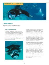
Plate 27. <strong>The</strong> ‘Ocean Fish’ <strong>Pitcairn</strong> <strong>Islands</strong> stamp issue<br />
from 2007 depicting six species <strong>of</strong> open-water fish<br />
regularly caught <strong>of</strong>f <strong>Pitcairn</strong>. Top row, from left to<br />
right: dogtooth tuna Gymnosarda unicolor; wahoo<br />
Acanthocybium solandri; mahi-mahi Coryphaena<br />
hippurus; bottom row, from left to right: yellowfin tuna<br />
Thunnus albacares; giant trevally Caranx ignobilis; bonito<br />
Sarda chiliensis lineolata.<br />
array <strong>of</strong> gastrointestinal, neurological and cardiological<br />
symptoms with treatment options being ineffective or<br />
very limited (Dickey and Plakas, 2009). In particular, <strong>the</strong><br />
coral reefs <strong>of</strong> Mangareva in <strong>the</strong> Gambier <strong>Islands</strong> hold<br />
large amounts <strong>of</strong> <strong>the</strong> din<strong>of</strong>lagellate Gambierdiscus<br />
toxicus, a ciguatoxin precursor which attaches itself to<br />
algae and traverses <strong>the</strong> food chain bioaccumulating in<br />
carnivorous fin fish. High subsequent and ongoing rates<br />
<strong>of</strong> intoxications by ciguatera recorded in <strong>the</strong> Gambier<br />
<strong>Islands</strong> have been associated with French nuclear testing<br />
in <strong>the</strong> area around Moruroa Atoll and associated military<br />
infrastructure development on Mangareva conducted<br />
during <strong>the</strong> period 1968 to <strong>the</strong> mid-1970s, although <strong>the</strong><br />
environmental pathways to <strong>the</strong> outbreak have not been<br />
established. While <strong>the</strong> existing presence <strong>of</strong> ciguatera<br />
is a potential barrier to <strong>the</strong> development <strong>of</strong> small-scale<br />
commercial fisheries in <strong>the</strong> Pacific <strong>Islands</strong> more generally,<br />
<strong>the</strong> Secretariat <strong>of</strong> <strong>the</strong> Pacific Community has proposed<br />
that <strong>the</strong> <strong>Pitcairn</strong> community may be in a good position to<br />
develop <strong>the</strong>ir inshore reef fisheries commercially for export<br />
to Mangareva (Michel Blanc, pers. comm., Nov. 2011),<br />
although <strong>the</strong> purchase and installation <strong>of</strong> a blast freezer<br />
will be necessary to ensure production meets food safety<br />
regulation standards. However, as yet no assessment <strong>of</strong><br />
stocks has been undertaken and <strong>the</strong> economics <strong>of</strong> such a<br />
venture have to be studied in detail.<br />
20<br />
17. ‘Nearshore waters’ here are defined as extending to<br />
approximately 2 km from low water mark or shallower<br />
than <strong>the</strong> 100 m depth contour.<br />
18. Note that Sargassum odontocarpum was originally<br />
recorded as Sargassum coriifolium by Tsuda (1976).<br />
<strong>The</strong> taxonomy <strong>of</strong> <strong>the</strong> genus Sargassum in French<br />
Polynesia was revised in 2008 (Mattio et al., 2008).<br />
19. <strong>The</strong> Foraminifera (“hole bearers”), or forams for short,<br />
are a large group <strong>of</strong> amoeboid protists which are<br />
among <strong>the</strong> commonest plankton species. <strong>The</strong>y have<br />
reticulating pseudopods, fine strands <strong>of</strong> cytoplasm<br />
that branch and merge to form a dynamic net. <strong>The</strong>y<br />
typically produce a test, or shell, which can have<br />
ei<strong>the</strong>r one or multiple chambers, some becoming<br />
quite elaborate in structure. <strong>The</strong>se shells are made <strong>of</strong><br />
calcium carbonate (CaCO3) or agglutinated sediment<br />
particles. About 275,000 species are recognised,<br />
both living and fossil. <strong>The</strong>y are usually less than 1 mm<br />
in size, but some are much larger, with <strong>the</strong> largest<br />
species reaching up to 20 cm. [Wikipedia entry,<br />
24Nov11. URL: en.wikipedia.org/wiki/Foraminifera].<br />
20. Note that only eight species <strong>of</strong> Foraminifera were listed<br />
from all four <strong>Pitcairn</strong> <strong>Islands</strong> by Palomares et al., 2011.<br />
21. Ostracoda is a class <strong>of</strong> <strong>the</strong> Crustacea, whose members<br />
are sometimes known as seed shrimps because <strong>of</strong> <strong>the</strong>ir<br />
appearance. Some 65,000 species (13,000 <strong>of</strong> which are<br />
extant taxa) have been identified, grouped into several<br />
orders. Ostracods are small crustaceans, typically around<br />
1 millimetre in size. <strong>The</strong>ir bodies are flattened from<br />
side to side and protected by a bivalve-like, chitinous<br />
or calcareous carapace or ‘shell’. Ecologically, marine<br />
ostracods can be part <strong>of</strong> <strong>the</strong> zooplankton or (most<br />
commonly) <strong>the</strong>y are part <strong>of</strong> <strong>the</strong> benthos, living on or<br />
inside <strong>the</strong> upper layer <strong>of</strong> <strong>the</strong> seafloor.<br />
22. <strong>The</strong> figure <strong>of</strong> 47 species consists <strong>of</strong> 28 named species, three<br />
new genera and 16 new species (Whatley et al. 2004).<br />
23. (http://library.puc.edu/pitcairn/studycenter/<br />
cruiseship.shtml, last accessed 7/12/2011).<br />
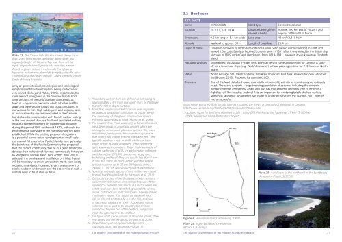
3.2 Henderson<br />
KEY FACTS<br />
Name HENDERSON Island type Elevated coral atoll<br />
Location 24°21’S, 128°19’W Distance/bearing from<br />
nearest island(s)<br />
<strong>The</strong> <strong>Marine</strong> <strong>Environment</strong> <strong>of</strong> <strong>the</strong> <strong>Pitcairn</strong> <strong>Islands</strong>: <strong>Pitcairn</strong> <strong>The</strong> <strong>Marine</strong> <strong>Environment</strong> <strong>of</strong> <strong>the</strong> <strong>Pitcairn</strong> <strong>Islands</strong>: Henderson<br />
Approx. 200 km ENE <strong>of</strong> <strong>Pitcairn</strong>; and<br />
approx. 360 km W <strong>of</strong> Ducie<br />
Dimensions 9.6 km long x 5.1 km wide Land area 43 km 2 (4,310 ha)*<br />
Altitude Sea level to approx. 33 m Length <strong>of</strong> coastline 26.4 km<br />
Origin <strong>of</strong> name European discovery by Pedro Fernandez de Quiros, who passed without landing in 1606 and<br />
named it San João Baptista. Received current name in 1831 after it was visited by <strong>the</strong> British ship<br />
Hercules in 1819 under Capt. Henderson. From 1819–1831, however, it was known as Elizabeth<br />
Island.<br />
Population/visitors Uninhabited. Occasional 2–3 day visits by <strong>Pitcairn</strong>ers to harvest miro wood for carving. A stop<strong>of</strong>f<br />
for a few cruise ships (e.g. World Discoverer), whose passengers land for 2–3 hours on North<br />
Beach.<br />
Status World Heritage Site (1988); Endemic Bird Area; Important Bird Area; Alliance for Zero Extinction<br />
site (Brooke, 2010). Proposed Ramsar site (2005).<br />
Overview One <strong>of</strong> <strong>the</strong> least disturbed raised coral atolls in <strong>the</strong> world, with its terrestrial ecosystems largely<br />
intact. <strong>The</strong> island supports a large breeding population <strong>of</strong> seabirds, including <strong>the</strong> endemic<br />
Henderson petrel Pterodroma atrata and also has four endemic landbirds, one <strong>of</strong> which is a<br />
flightless rail. <strong>The</strong> beaches and reef flats are important for wintering bristle-thighed curlews<br />
Numenius tahitiensis. An attempt was made to eradicate rats from <strong>the</strong> island in 2011 but this<br />
was unsuccessful.<br />
(Information extracted from various sources including <strong>the</strong> RSPB’s A Directory <strong>of</strong> Wetlands in Oceania:<br />
http://www.wetlands.org/RSIS/WKBASE/OceaniaDir/<strong>Pitcairn</strong>.htm)<br />
* Updated figure for land area obtained in 2011 using GPS. Previously, <strong>the</strong> figure was 37 km2 (3,700 ha)<br />
(RSPB, Henderson Island Restoration Project).<br />
Figure 8. Henderson Island (after Irving, 1995).<br />
Plate 29. (right) East Beach, Henderson.<br />
(Photo: R.A. Irving)<br />
Plate 28. Aerial view <strong>of</strong> <strong>the</strong> north end <strong>of</strong> <strong>the</strong> East Beach,<br />
Henderson. (Photo: SPSCEPI)<br />
21