Kern County General Plan - Chapter 1, Land Use - County of Kern
Kern County General Plan - Chapter 1, Land Use - County of Kern
Kern County General Plan - Chapter 1, Land Use - County of Kern
You also want an ePaper? Increase the reach of your titles
YUMPU automatically turns print PDFs into web optimized ePapers that Google loves.
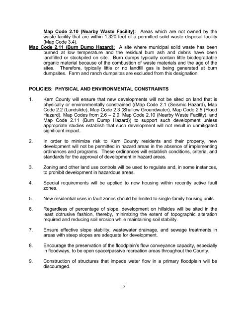
Map Code 2.10 (Nearby Waste Facility): Areas which are not owned by the<br />
waste facility that are within 1,320 feet <strong>of</strong> a permitted solid waste disposal facility<br />
(Map Code 3.4).<br />
Map Code 2.11 (Burn Dump Hazard): A site where municipal solid waste has been<br />
burned at low temperature and the residual burn ash and debris have been<br />
landfilled or stockpiled on site. Burn dumps typically contain little biodegradable<br />
organic material because <strong>of</strong> the combustion <strong>of</strong> waste materials and the age <strong>of</strong> the<br />
sites. Therefore, typically little or no landfill gas is being generated at burn<br />
dumpsites. Farm and ranch dumpsites are excluded from this designation.<br />
POLICIES: PHYSICAL AND ENVIRONMENTAL CONSTRAINTS<br />
1. <strong>Kern</strong> <strong>County</strong> will ensure that new developments will not be sited on land that is<br />
physically or environmentally constrained ((Map Code 2.1 (Seismic Hazard), Map<br />
Code 2.2 (<strong>Land</strong>slide), Map Code 2.3 (Shallow Groundwater), Map Code 2.5 (Flood<br />
Hazard), Map Codes from 2.6 – 2.9, Map Code 2.10 (Nearby Waste Facility), and<br />
Map Code 2.11 (Burn Dump Hazard)) to support such development unless<br />
appropriate studies establish that such development will not result in unmitigated<br />
significant impact.<br />
2. In order to minimize risk to <strong>Kern</strong> <strong>County</strong> residents and their property, new<br />
development will not be permitted in hazard areas in the absence <strong>of</strong> implementing<br />
ordinances and programs. These ordinances will establish conditions, criteria, and<br />
standards for the approval <strong>of</strong> development in hazard areas.<br />
3. Zoning and other land use controls will be used to regulate and, in some instances,<br />
to prohibit development in hazardous areas.<br />
4. Special requirements will be applied to new housing within recently active fault<br />
zones.<br />
5. New residential uses in fault zones should be limited to single-family housing units.<br />
6. Regardless <strong>of</strong> percentage <strong>of</strong> slope, development on hillsides will be sited in the<br />
least obtrusive fashion, thereby, minimizing the extent <strong>of</strong> topographic alteration<br />
required and reducing soil erosion while maintaining soil stability.<br />
7. Ensure effective slope stability, wastewater drainage, and sewage treatments in<br />
areas with steep slopes are adequate for development.<br />
8. Encourage the preservation <strong>of</strong> the floodplain’s flow conveyance capacity, especially<br />
in floodways, to be open space/passive recreation areas throughout the <strong>County</strong>.<br />
9. Construction <strong>of</strong> structures that impede water flow in a primary floodplain will be<br />
discouraged.<br />
12


