Kern County General Plan - Chapter 1, Land Use - County of Kern
Kern County General Plan - Chapter 1, Land Use - County of Kern
Kern County General Plan - Chapter 1, Land Use - County of Kern
Create successful ePaper yourself
Turn your PDF publications into a flip-book with our unique Google optimized e-Paper software.
5. Promote mixed-densities within developments to increase average density,<br />
increase greenbelts and paths, reduce consumption <strong>of</strong> agriculture land, open<br />
space, and reduce costs <strong>of</strong> infrastructure.<br />
6. Promote the conservation <strong>of</strong> water quantity and quality in <strong>Kern</strong> <strong>County</strong>.<br />
7. Minimize land use conflicts between residential and resource, commercial, or<br />
industrial land uses.<br />
8. Ensure compatible land uses around airports.<br />
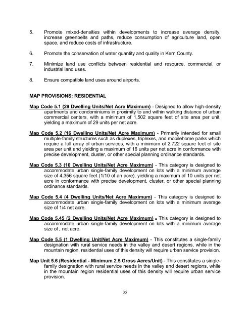
MAP PROVISIONS: RESIDENTIAL<br />
Map Code 5.1 (29 Dwelling Units/Net Acre Maximum) - Designed to allow high-density<br />
apartments and condominiums in proximity to and within walking distance <strong>of</strong> urban<br />
commercial centers, with a minimum <strong>of</strong> 1,502 square feet <strong>of</strong> site area per unit,<br />
yielding a maximum <strong>of</strong> 29 units per net acre.<br />
Map Code 5.2 (16 Dwelling Units/Net Acre Maximum) - Primarily intended for small<br />
multiple-family structures such as duplexes, triplexes, and mobilehome parks which<br />
require a full array <strong>of</strong> urban services, with a minimum <strong>of</strong> 2,722 square feet <strong>of</strong> site<br />
area per unit and yielding a maximum <strong>of</strong> 16 units per net acre in conformance with<br />
precise development, cluster, or other special planning ordinance standards.<br />
Map Code 5.3 (10 Dwelling Units/Net Acre Maximum) - This category is designed to<br />
accommodate urban single-family development on lots with a minimum average<br />
size <strong>of</strong> 4,356 square feet (1/10 <strong>of</strong> an acre), yielding a maximum <strong>of</strong> 10 units per net<br />
acre in conformance with precise development, cluster, or other special planning<br />
ordinance standards.<br />
Map Code 5.4 (4 Dwelling Units/Net Acre Maximum) - This category is designed to<br />
accommodate urban single-family development on lots with a minimum average<br />
size <strong>of</strong> 1/4 net acre.<br />
Map Code 5.45 (2 Dwelling Units/Net Acre Maximum) B This category is designed to<br />
accommodate urban single-family development on lots with a minimum average<br />
size <strong>of</strong> 2 net acre.<br />
Map Code 5.5 (1 Dwelling Unit/Net Acre Maximum) - This constitutes a single-family<br />
designation with rural service needs in the valley and desert regions, while in the<br />
mountain region, residential uses <strong>of</strong> this density will require urban service provision.<br />
Map Unit 5.6 (Residential - Minimum 2.5 Gross Acres/Unit) - This constitutes a singlefamily<br />
designation with rural service needs in the valley and desert regions, while<br />
in the mountain region residential uses <strong>of</strong> this density will require urban service<br />
provision.<br />
35


