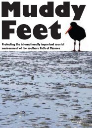
MUDDY FEET - Auckland Regional Council
MUDDY FEET - Auckland Regional Council
MUDDY FEET - Auckland Regional Council

Create successful ePaper yourself
Turn your PDF publications into a flip-book with our unique Google optimized e-Paper software.
10<br />
which probably resulted in erosion and an increased sediment load in rivers (Phillips 2000).<br />
Inter-tribal wars, land sales and European development all contributed to a re-orientation of<br />
lifestyle in the 1800s, and along with this a new Hauraki social order emerged (Hauraki Maori<br />
Trust Board 1999).<br />
1.6.2 Hauraki Plains at time of first European explorers and settlers<br />
At the time of first contact between Maori and Europeans, much of the land between the river<br />
and the foothills, on the eastern bank of the Waihou River, was cleared. A narrow strip of<br />
land along the western bank of the Waihou River (100-600 m wide) was cleared. Kahikatea<br />
(Dacrycarpus dacrydioides) forest was dominant. On both sides of the river there were large<br />
areas of raupo (Typha orientalis) and flax (Phormium tenax) swamp (Phillips 2000). The<br />
extensive coastal plains of the southern Firth of Thames (of which the current Ramsar Site<br />
occupies a small fraction) were recognized by Captain Cook and Joseph Banks in 1769 as “a<br />
garden and a pasture in which the best elements of British society might grow into an ideal<br />
nation”, in spite of being blanketed at the time by a vast Kahikatea forest containing the<br />
biggest trees they had ever seen (Park 1995).<br />
Cook and Banks (Beaglehole 1955 and 1963) also commented on the swamps and mangroves<br />
at the river mouth, and the mudflats and mangroves appeared on the early maps by Captain<br />
Cook and Captain Wilson (Phillips 2000).<br />
Cook and Banks considered the “Thames” (Waihou) River to be the best site for the<br />
establishment of a new colony (in terms of protected anchorage, fertile soil, huge expanse of<br />
flat land, vast quantities of fine timber and abundant fishery resources).<br />
An area of approximately 200,000 acres constituting the Hauraki Plains, originally known to<br />
Europeans as the Piako Swamp, was historically prone to regular flooding, and thus limited<br />
the possibilities for human habitation. All of the Maori settlements of the extensive Waihou<br />
and Piako river systems were on the highest bits of ground (including old raised shorelines) to<br />
minimize the risks of flooding, and for defensive purposes (Phillips 2000, Park 1995).<br />
Several early accounts mention that the lower reaches of the trees of the forest were<br />
perpetually clothed with films of mud and hanging debris from regular washings by the siltladen<br />
tides and floods. The early people grew vegetables in small plots of rich alluvial soil,<br />
fished, hunted, gathered shellfish from the water and collected fruits (particularly Kahikatea<br />
berries) and flax and raupo reeds from the land (Hauraki Maori Trust Board 1999).<br />
1.6.3 European settlement<br />
The swamp-growing Kahikatea proved unsuitable for the timber trade, but it still was<br />
extensively harvested for various uses (such as butter boxes) in the 2 nd half of the 19 th century.<br />
Most of the kahikatea used in that era was milled on the banks of the Waihou. The great<br />
expanses of flax and raupo swamp were highly valued by Maori as a source of fibre for<br />
clothing, cordage and roofing (Phillips 2000). Flax was also used by the European colonists<br />
who built many mills on the plains for processing it.<br />
Dairy farming was initiated on a very small scale by the early colonists on the west bank of<br />
the Waihou in the 1880s. The cream was churned into butter at home, and the skim milk fed<br />
to fattening pigs. Extensive drainage of the Hauraki Plains has been undertaken since early<br />
settlement. Some of the drains were cut by the first farmers in the 19th century, and drainage<br />
works as well as flood protection works continue up to the present day (Phillips 2000).<br />
The first organized land surveys and initial drainage efforts began in 1905, the same year the<br />
first creamery was established at Netherton. The Hauraki Plains Act was passed in 1908,<br />
EcoQuest Education Foundation EQRS/1 12/04