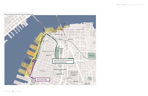
Figure II-6 Recommended NYCT Bus Route Extensions SAm SChwARTz PLLC hDR-DANIEL FRANkFURT 360 360 33 urm rman rmreet ma ma man an Sttr Stre Stree ree ee et et et Furm PIER PIER 66 PIER PIER 55 PIER PIER 33 PIER PIER 22 PIER 4 Water Taxi/ Ferry Landing T Water Taxi/ Ferry Landing FURMAN ST ATLANTIC AV PIER PIER 11 BROOKLYN BRIDGE BROOKLYN HEIGHTS ESPLANDE FURMAN ST Water Taxi/ Ferry Landing SQUIBB PARK BROOKLYN HEIGHTS JORALEMON ST · B63 to Bay Ridge CLARK ST COBBLE HILL OLD FULTON ST CADMAN PZ W DUMBO COURT ST MANHATTAN BRIDGE CADMAN PLAZA PARK FRONT ST YORK ST HIGH ST Water Taxi/ Ferry Landing BOROUGH HALL BOROUGH HALL PEARL ST HIGH ST JAY ST MC LAUGHLIN PARK JAY ST YORK ST · B26, B38, and B52 to Bushwick · B25 to East New York DOWNTOWN BROOKLYN LAWRENCE ST HOYT ST VINEGAR HILL HOYT ST DEKALB AVE COMMODORE J BARRY PARK FORT GREENE PARK FORT GREENE FULTON ST WILLAMSBURG BROOKLYN BRIDGE PARK TRANSPORTATION AND ACCESS STUDY 1 CLINTON AVE
SAm SChwARTz PLLC hDR-DANIEL FRANkFURT III. Pedestrian Access Visitors to the <strong>Park</strong> will arrive using every mode of transportation, but all will eventually experience the <strong>Park</strong> from the pedestrian point of view. Major pedestrian access points, or gateways to the <strong>Park</strong>, are examined in this section for their potential to provide safe and convenient pedestrian access to the <strong>Park</strong>. Two major gateways to the <strong>Park</strong> include the Old Fulton Street and Atlantic Avenue entrances because of their proximity to transit and nearby attractions and because <strong>Park</strong> access points between these locations are limited. In addition, the <strong>Park</strong>’s design includes designated gateways at these two locations. The pedestrian corridor along Old Fulton Street provides access to the north-central gateway to the <strong>Park</strong> and is within a 10- to 15-minute walk from the <strong>Brooklyn</strong> <strong>Bridge</strong>; the Promenade; the York Street (F), High Street (A,C), and Clark Street (2,3) subway stations, as well as the neighborhoods of DUMBO and <strong>Brooklyn</strong> Heights (shown in Figure III-1). The pedestrian corridor along Atlantic Avenue provides access to the southern-most gateway to the <strong>Park</strong> and is within a 10- to 15-minute walk from the Promenade, the Borough Hall (2,3,4,5) and Court Street (M,R) subway stations, as well as the neighborhoods of <strong>Brooklyn</strong> Heights, Downtown <strong>Brooklyn</strong>, and Cobble Hill (also shown in Figure III-1). Both Old Fulton Street and Atlantic Avenue are expected to be well-traveled pedestrian routes to the <strong>Park</strong> and should be as clear, safe, and as well-defined as possible for a wide range of <strong>Park</strong> visitors. In the existing condition, both the Old Fulton Street and the Atlantic Avenue pedestrian corridors have numerous pedestrian-vehicle conflict points, many of which can be eliminated or made safer, as described in the following sections. The planned reconstruction of the cantilevered segment of the <strong>Brooklyn</strong>-Queens Expressway (BQE) presents a unique opportunity to reconfigure the approaches to the highway to significantly improve the pedestrian experience. In general, to improve the pedestrian environment, conflicts between pedestrians and vehicles should be eliminated wherever possible. Where pedestrian-vehicle conflicts cannot be avoided (for example, turning vehicles conflicting with pedestrians crossing at intersections), crossings should be made as safe and clear as possible by shortening crossing lengths to minimize pedestrian time in the roadway. Reclaiming excessive vehicle space for pedestrians (for instance, narrowing roadways and/or widening sidewalks) can promote slower vehicle travel speeds and provide more pedestrian comfort. In addition, any irregularly shaped intersections or crossings that may confuse pedestrians regarding the directions vehicles will be approaching (for example, more than four approaches to an intersection) or that may promote higher vehicle speeds at pedestrian crossings (for example, channelized right turn lanes) should be normalized wherever possible. In other words, street geometries should be reconfigured to normal, right-angled, four-approach intersections to promote pedestrian safety and driver awareness. The principles described above were applied when suggesting improvements to Old Fulton Street and Atlantic Avenue near the <strong>Park</strong>. BROOKLYN BRIDGE PARK TRANSPORTATION AND ACCESS STUDY 1 Community Comments Pedestrian access improvements were addressed at the community meetings held on October 4, 2006, and March 20, 2007, and the community charrette held on December 5, 2006. Comments and suggestions raised by the community at these events were generally consistent with the general pedestrian improvements described above. For example, it was suggested that the pedestrian experience be improved along Old Fulton Street and Atlantic Avenue by minimizing the number, length, and complexity of crossings. It was suggested that a particular focus be given to pedestrian crossings at the BQE on/off ramps because of the high vehicle volumes and speeds near Old Fulton Street and Atlantic Avenue and the danger presented to pedestrians. In addition, the community suggested improvements such as widening sidewalks and adding street trees, parking, center medians, curb extensions, and other traffic calming measures to slow vehicles and claim additional pedestrian space. Other specific recommendations made by the community were as follows: • • • • Improve pedestrian access along the north side of Old Fulton Street to Cadman Plaza, including additional crossings between Hicks Street and Prospect Street Improve pedestrian access from the <strong>Brooklyn</strong> <strong>Bridge</strong> pedestrian entrance/ exit to Old Fulton Street Extend <strong>Park</strong>-related improvements east of the BQE at Atlantic Avenue to create a true <strong>Park</strong> gateway Consider a roundabout or other improvements at the terminus of Atlantic Avenue so that it feels like a <strong>Park</strong> entrance, not the end of a street Old Fulton Street Pedestrian Corridor Existing Conflicts and Safety Issues Existing vehicle-pedestrian conflict points along Old Fulton Street are highlighted in red in Figure III-2. Pedestrians on the northern side of Old Fulton Street heading westward (toward the <strong>Park</strong>) encounter several dangerous conflicts with vehicles, particularly those coming off the BQE. There are four consecutive conflict points within a short distance at the BQE exit ramp and Front Street. These four pedestrian crossings, also shown in Figure III-3, are meandering as a result of the channelized turn lanes, and have poor visibility for both pedestrians and vehicles.