Brooklyn Bridge Park Transportation Study, 3/2008
Brooklyn Bridge Park Transportation Study, 3/2008
Brooklyn Bridge Park Transportation Study, 3/2008

You also want an ePaper? Increase the reach of your titles
YUMPU automatically turns print PDFs into web optimized ePapers that Google loves.
SAm SChwARTz PLLC hDR-DANIEL FRANkFURT<br />
RED HOOK<br />
Figure IV-6 Bicycle Routes to Southern <strong>Park</strong> Entrances<br />
•<br />
RED HOOK PARK<br />
•<br />
Existing City y<br />
bike route<br />
Bike routes proposed Pb by b by<br />
The City<br />
Water<br />
Taxi/<br />
Ferry<br />
Landing<br />
Water<br />
Taxi/<br />
Ferry<br />
Landing<br />
PIER PIEERR 55<br />
PIER PPIEERR 33 PIER PIER 22<br />
PIER 4<br />
BROOKLYN HEIGHTS IG GHT G GH<br />
COBBLE HILL<br />
State Street route would provide similar CARROLL access. GARDENS The Joralemon Street route would<br />
RED HOOK RECREATION AREA<br />
PIER PI PI PIEER<br />
666 PPP<br />
Waterr Wat<br />
Taxi/ Taxi/ Taxi<br />
Fe Fe erry erry rry rry<br />
Landing ding ding ng ng ng<br />
Bro <strong>Brooklyn</strong> oklyn klyn GGreen<br />
Wate way w<br />
Initi tia ative a ive<br />
Sam Schwartz Schwa hwartz, z, PLLC C<br />
<strong>Park</strong> Access from <strong>Brooklyn</strong><br />
<strong>Bridge</strong>/Downtown <strong>Brooklyn</strong><br />
and <strong>Brooklyn</strong> Heights to Old<br />
Fulton entrance<br />
BROOKLYN HEIGHTS ESPLANDE<br />
CARROLL PARK<br />
be extended west into the <strong>Park</strong>, providing <strong>Park</strong> access for westbound bicyclists.<br />
SQUIBB<br />
PARK<br />
<strong>Park</strong> Access ess ss from fro from m Downtow<br />
Dow Downtow<br />
Downtown wn<br />
<strong>Brooklyn</strong>, Brook <strong>Brooklyn</strong> rooklyn yn Heigh Height Heig ght hts,<br />
Boerum Hill and Cobb Cobble bble Hill H<br />
to<br />
southern thern eentrance H<br />
North of Atlantic Avenue, the City’s proposed Joralemon Street bicycle route should<br />
This route would intersect the Henry/Clinton Street bicycle routes and connect to<br />
Downtown <strong>Brooklyn</strong>. For eastbound cyclists, the recommended Columbia Place/<br />
be two-way for a short section on Joralemon Street between Columbia Place and<br />
the <strong>Park</strong>. Given that Joralemon Street is one-way westbound, the two-way portion<br />
of the route west of Columbia Place could not be implemented until Joralemon<br />
Street is closed to vehicular access at this location (as described in the FEIS) or<br />
another treatment is implemented to accommodate the short two-way section.<br />
South of Atlantic Avenue, for eastbound cyclists, bicycle routes for Congress, Court,<br />
Wyckoff, and Smith Streets would connect the existing Dean/Bergen Street bicycle<br />
routes to the <strong>Park</strong>’s Atlantic Avenue entrance via Columbia Street. For westbound<br />
cyclists, the recommended route via Pacific, Court, and Kane Streets would provide<br />
similar access.<br />
GOWANUS<br />
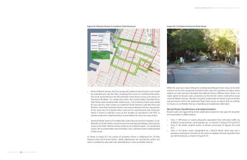
As shown in Figure IV-7, the surface of Joralemon Street is cobblestone for 1/8 mile<br />
between Hicks and Furman Streets. While cobblestones are not ideal for cyclists, the<br />
route is nonetheless safer and more desirable than a route on Atlantic Avenue.<br />
PLAZA<br />
PARK<br />
MC LAUGHLIN<br />
PARK<br />
DOWNTOWN<br />
BROOKLYN<br />
BOERUM HILL<br />
THOMAS GREENE PLAYGROUND<br />
BYRNE PARK<br />
PARK SLOPE<br />
COMMODORE J<br />
BARRY PARK<br />
Figure IV-7 Joralemon Street at Hicks Street<br />
BROOKLYN BRIDGE PARK TRANSPORTATION AND ACCESS STUDY<br />
FORT GREENE PARK<br />
FORT GREENE<br />
While the east-west routes linking the existing Dean/Bergen Street routes to the <strong>Park</strong><br />
entrance via the City’s proposed Columbia Street route are somewhat circuitous, these<br />
options are safer and more desirable than Atlantic Avenue. Without them, there is no<br />
viable option for bicycle route connections to the <strong>Park</strong> for visitors coming from areas<br />
south of Atlantic Avenue. Therefore, bicyclists would either be forced to go out of their<br />
PROSPECT HEIGHTS<br />
way and travel north to the Joralemon/State Street routes, an option they are unlikely<br />
to choose, or use Atlantic Avenue, a hazardous and unpleasant alternative.<br />
Bicycle Route Classifications and Implementation<br />
Bicycle routes are organized by three classifications based on how space for bicyclists<br />
and automobiles is differentiated:<br />
•<br />
•<br />
•<br />
Class 1: Off-street or routes physically separated from vehicular traffic by<br />
bollards, Jersey barriers, landscaping, etc., as shown in Figures IV-8 and IV-9<br />
Class 2: On-street, striped routes, as shown previously in Figures IV-2 and<br />
IV-3<br />
Class 3: On-street route designated by a Bicycle Route street sign and a<br />
pavement marking of a bicyclist on the street at regularly intervals (typically three<br />
per 200-foot block), as shown in Figure IV-10