Brooklyn Bridge Park Transportation Study, 3/2008
Brooklyn Bridge Park Transportation Study, 3/2008
Brooklyn Bridge Park Transportation Study, 3/2008

Create successful ePaper yourself
Turn your PDF publications into a flip-book with our unique Google optimized e-Paper software.
SAm SChwARTz PLLC hDR-DANIEL FRANkFURT<br />
I. Introduction<br />
The Downtown <strong>Brooklyn</strong> Waterfront Local Development Corporation (LDC)<br />
retained Sam Schwartz PLLC and HDR-Daniel Frankfurt to develop alternatives and<br />
recommendations to improve non-automobile access to the future <strong>Brooklyn</strong> <strong>Bridge</strong><br />
<strong>Park</strong> (<strong>Park</strong>). The transportation and access study assessed potential improvements in<br />
the following areas:<br />
•<br />
•<br />
•<br />
•<br />
•<br />
•<br />
•<br />
New York City Transit (NYCT) bus routes<br />
Pedestrian access<br />
Bicycle routes<br />
Shuttle bus service<br />
Waterborne transport<br />
Vertical pedestrian connection<br />
Clark Street subway station<br />
The study was prepared to review ways of enhancing transportation access beyond<br />
what was proposed in the <strong>Brooklyn</strong> <strong>Bridge</strong> <strong>Park</strong> Master Plan and Final Environmental<br />
Impact Statement (FEIS). Specifically, the study did not develop recommendations or<br />
provide comments on issues concerning circulation and access within the <strong>Park</strong>. It was<br />
assumed that the <strong>Park</strong> would provide major at-grade connections at Old Fulton Street<br />
and Atlantic Avenue. As indicated in the <strong>Brooklyn</strong> <strong>Bridge</strong> <strong>Park</strong> Master Plan and FEIS,<br />
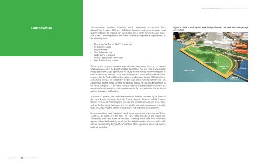
a pedestrian bridge would connect the existing Squibb <strong>Park</strong> in <strong>Brooklyn</strong> Heights to<br />
the <strong>Park</strong> (see Figure I-1). If deemed feasible and desirable, the implementation of the<br />
recommendations would occur independent of the <strong>Park</strong> and would require additional<br />
reviews, approvals, and funding.<br />
As shown in Figure I-2, the study area consists of the <strong>Park</strong>, bordered by Jay Street to<br />
the north, Atlantic Avenue to the south, Furman Street to the west, and the <strong>Brooklyn</strong><br />
Heights Promenade (Promenade) to the east and immediately adjacent areas. Tasks<br />
such as the bus route extensions and the shuttle bus service considered a broader<br />
study area, including the Atlantic Avenue transit hub and Downtown <strong>Brooklyn</strong>.<br />
Recommendations were developed based on an assessment of existing and future<br />
conditions, as outlined in the FEIS. All <strong>Park</strong> visitor projections and modal split<br />
assumptions were also based on the FEIS. Meetings were held with community<br />
representatives; the <strong>Park</strong> designer, Michael Van Valkenburgh Associates; as well as with<br />
relevant New York City (City) and New York State (State) agencies to discuss alternatives<br />
and their feasibility.<br />
BROOKLYN BRIDGE PARK TRANSPORTATION AND ACCESS STUDY<br />
Figure I-1 Pier 1 and Squibb <strong>Park</strong> <strong>Bridge</strong> (Source: Michael Van Valkenburgh<br />
Associates)