Brooklyn Bridge Park Transportation Study, 3/2008
Brooklyn Bridge Park Transportation Study, 3/2008
Brooklyn Bridge Park Transportation Study, 3/2008

Create successful ePaper yourself
Turn your PDF publications into a flip-book with our unique Google optimized e-Paper software.
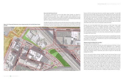
Figure BROOKLYN III-5 Proposed BRIDGE PARK Pedestrian Access Improvements for the Old Fulton Street<br />
Corridor<br />
FURMAN ST<br />
COLUMBIA HEIGHTS<br />
SAm SChwARTz PLLC hDR-DANIEL FRANkFURT<br />
EVERIT ST<br />
OLD FULTON ST<br />
VINE ST<br />
ELIZABETH PL<br />
DOUGHTY ST<br />
Recommended Improvements<br />
The proposed improvements for the Old Fulton Street Corridor are shown in<br />
schematically form in Figure III-5. In general, the goal of the improvements is to<br />
eliminate as many pedestrian-vehicle conflicts as possible, shorten pedestrian crossing<br />
lengths, create a more pedestrian-friendly environment, and reclaim excessively wide<br />
asphalt or roadway sections for pedestrian and open space.<br />
The BQE off-ramp that currently intersects with Old Fulton Street could be reconfigured<br />
to intersect with Front Street instead. The new intersection of the BQE off-ramp with<br />
Front Street could be located opposite the existing intersection of Dock and Front<br />
HICKS ST<br />
DOCK ST<br />
FRONT ST<br />
WATER ST<br />
YORK ST<br />
BQE EXIT RAMP<br />
BROOKLYN BRIDGE PARK TRANSPORTATION AND ACCESS STUDY 1<br />
Streets, and the new four-leg intersection could be signal-controlled. To reach Old<br />
Fulton Street from the BQE, vehicles would turn left (westbound) onto Front Street and<br />
follow that to its intersection with Old Fulton Street. The intersection of Front Street and<br />
Old Fulton Street would also be normalized to approach at a right angle, eliminating<br />
the channelized turns. As a result, the four meandering pedestrian crossings on the<br />
north side of Old Fulton Street at Front Street would be consolidated to one, normalized<br />
crossing. These improvements could create up to 0.6 acres of open space on the north<br />
side of Old Fulton Street, east of its intersection with Front Street.<br />
Similarly, the two channelized Hicks Street entrances at Old Fulton Street could<br />
be reconfigured to create one normalized intersection, resulting in a shortened,<br />
consolidated pedestrian crossing. In addition, Old Fulton Street at Water and Everit<br />
Streets could be narrowed to shorten the crossing from 110 feet to 53 feet, create a<br />
more pedestrian-friendly environment, and calm vehicles. Water Street could also<br />
be narrowed and converted to a one-way street, reducing the length of its pedestrian<br />
crossing at Old Fulton Street.<br />
In addition to promoting pedestrian safety, the improvements could add approximately<br />
1.1 acres of new open space. These improvements should be studied further to estimate<br />
their effects on the area traffic network and to assess the structural feasibility of the<br />
potential ramp configuration.<br />
Atlantic Avenue Pedestrian Corridor<br />
Existing Conflicts and Safety Issues<br />
The Atlantic Avenue pedestrian corridor, the southern gateway to the <strong>Park</strong>, is shown<br />
in Figure III-6, with existing vehicle conflict points highlighted in red. Pedestrians<br />
heading westward toward the <strong>Park</strong> on Atlantic Avenue must contend with several<br />
vehicle conflict points, including the on- and off-ramps to the BQE on the north and<br />
south side of Atlantic Avenue, respectively (also shown in Figure III-7 with the <strong>Park</strong><br />
highlighted in yellow).<br />
On the north side of Atlantic Avenue, the BQE on-ramp and Furman Street do not<br />
intersect with Atlantic Avenue at right angles, making it easier for vehicles to make<br />
turning movements at higher speeds and resulting in long, difficult pedestrian crossings.<br />
The channelized right-turn from Atlantic Avenue to the BQE on-ramp, allowing cars to<br />
make the turning movement at higher speeds, ultimately serves little purpose given<br />
the stop sign at the end of the ramp immediately prior to the ramp’s merge with the<br />
BQE. Similarly, on the south side of Atlantic Avenue, the BQE off-ramp channelized<br />
right turn lane onto Atlantic Avenue allows vehicles to make the turning movement<br />
at higher speeds than a normalized, right-angle intersection, resulting in decreased<br />
safety at the pedestrian crossing. In addition, the unusual S-curve geometry at the<br />
intersection of Columbia Street/Furman Street and Atlantic Avenue is confusing for<br />
vehicles and pedestrians alike, and results in additional, lengthy pedestrian crossings.