Brooklyn Bridge Park Transportation Study, 3/2008
Brooklyn Bridge Park Transportation Study, 3/2008
Brooklyn Bridge Park Transportation Study, 3/2008

You also want an ePaper? Increase the reach of your titles
YUMPU automatically turns print PDFs into web optimized ePapers that Google loves.
SAm SChwARTz PLLC hDR-DANIEL FRANkFURT<br />
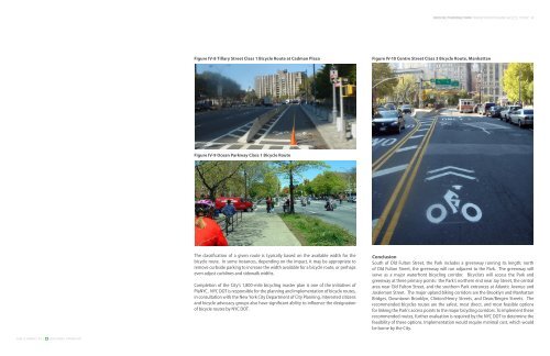
Figure IV-8 Tillary Street Class 1 Bicycle Route at Cadman Plaza<br />
Figure IV-9 Ocean <strong>Park</strong>way Class 1 Bicycle Route<br />
The classification of a given route is typically based on the available width for the<br />
bicycle route. In some instances, depending on the impact, it may be appropriate to<br />
remove curbside parking to increase the width available for a bicycle route, or perhaps<br />
even adjust curblines and sidewalk widths.<br />
Completion of the City’s 1,800-mile bicycling master plan is one of the initiatives of<br />
PlaNYC. NYC DOT is responsible for the planning and implementation of bicycle routes,<br />
in consultation with the New York City Department of City Planning. Interested citizens<br />
and bicycle advocacy groups also have significant ability to influence the designation<br />
of bicycle routes by NYC DOT.<br />
BROOKLYN BRIDGE PARK TRANSPORTATION AND ACCESS STUDY<br />
Figure IV-10 Centre Street Class 3 Bicycle Route, Manhattan<br />
Conclusion<br />
South of Old Fulton Street, the <strong>Park</strong> includes a greenway running its length; north<br />
of Old Fulton Street, the greenway will run adjacent to the <strong>Park</strong>. The greenway will<br />
serve as a major waterfront bicycling corridor. Bicyclists will access the <strong>Park</strong> and<br />
greenway at three primary points: the <strong>Park</strong>’s northern end near Jay Street, the central<br />
area near Old Fulton Street, and the southern <strong>Park</strong> entrances at Atlantic Avenue and<br />
Joralemon Street. The major upland biking corridors are the <strong>Brooklyn</strong> and Manhattan<br />
<strong>Bridge</strong>s, Downtown <strong>Brooklyn</strong>, Clinton/Henry Streets, and Dean/Bergen Streets. The<br />
recommended bicycles routes are the safest, most direct, and most feasible options<br />
for linking the <strong>Park</strong>’s access points to the major bicycling corridors. To implement these<br />
recommended routes, further evaluation is required by the NYC DOT to determine the<br />
feasibility of these options. Implementation would require minimal cost, which would<br />
be borne by the City.