Edición No. 4 - Andinatraffic
Edición No. 4 - Andinatraffic
Edición No. 4 - Andinatraffic

You also want an ePaper? Increase the reach of your titles
YUMPU automatically turns print PDFs into web optimized ePapers that Google loves.
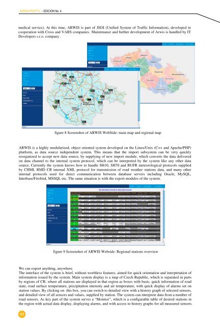
history begins in the year 1998, when ChanGroup s.r.o. started the development of a system for viewing datafrom LUFFT road weather stations. At 2004, in cooperation with Czech Hydrometeorological Institute and TheARWIS from LUFFT is a well road established weather stations. system for At 2004, processing cooperation and on-line with presentation Czech Hydrometeorological of road weather stations Institute data. and It's TheRoadhistoryand Motorway Directorate of the Czech Republic, ARWIS becomes a common platform for roadRoad begins and Motorway in the year Directorate 1998, when of ChanGroup the Czech s.r.o. Republic, started ARWIS the development becomes of a common a system platform viewing for data roadmaintenancefrom ANDINATRAFFIC system - EDICION of <strong>No</strong>. Road 4 and Motorway Directorate of the Czech Republic, aimed at highly specialized,maintenance LUFFT road system weather of Road stations. and At Motorway 2004, in cooperation Directorate of with the Czech Hydrometeorological Republic, aimed at highly Institute specialized, and TheveryRoadfast and precise exchange of information for decision support in winter road maintenance. Data in thevery and fast Motorway and precise Directorate exchange of of information the Czech for Republic, decision ARWIS support becomes in winter a road common maintenance. platform Data for road in thesystemmaintenanceare not limited by road maintenance relevant data only, but there are functions of the system, which aresystem are not system limited of by Road road and maintenance Motorway relevant Directorate data of only, the Czech but there Republic, are functions aimed of at the highly system, specialized, which areserving for sharing data between all parts of Integrated Rescue System (police, fire rescue service, emergencyvery serving fast and for sharing precise data exchange between of all information parts of Integrated for decision Rescue support System in winter (police, road fire maintenance. rescue service, Data emergency in themedical service). At this time, ARWIS is part of JSDI (Unified System of Traffic Information), developed insystem medical are service). not limited At by this road time, maintenance ARWIS is relevant part of JSDI data only, (Unified but System there are of functions Traffic Information), of the system, developed which are incooperation with Cross and VARS companies. Maintenance and further development of Arwis is handled by ITserving cooperation for sharing with Cross data between and VARS all companies. parts of Integrated Maintenance Rescue and System further (police, development fire rescue of Arwis service, is handled emergency by ITDevelopers s.r.o. company .medical Developers service). s.r.o. At company this time, . ARWIS is part of JSDI (Unified System of Traffic Information), developed incooperation with Cross and VARS companies. Maintenance and further development of Arwis is handled by ITDevelopers s.r.o. company .figure 8 Screenshot of ARWIS WebSide: main map and regional mapfigure 8 Screenshot of ARWIS WebSide: main map and regional mapARWIS is a highly modularized, object oriented system developed on the Linux/Unix (C++ and Apache/PHP)ARWIS is a highlyplatform, as data source figuremodularized,independent 8 Screenshotobjectsystem. oforientedARWISsystemThis WebSide:developedmeans that main the maponimport andthe Linux/Unixregional subsystem map(C++ and Apache/PHP)can be very quicklyplatform, as data source independent system. This means that the import subsystem can be very quicklyreorganized to accept new data source, by supplying of new import module, which converts the data deliveredARWIS reorganized is a highly to accept modularized, new data object source, oriented by supplying system of developed new import on module, the Linux/Unix which converts (C++ and the Apache/PHP) data deliveredon data channel to the internal system protocol, which can be interpreted by the system like any other dataplatform, on data as channel data source to the internal independent system system. protocol, This which means can that be the interpreted import by subsystem the system can like be very any other quickly datasource.reorganizedCurrently the system knows how to handle SH10, SH70 and BUFR meteorological protocols suppliedsource. Currently to accept the new system data knows source, how by supplying to handle of SH10, new SH70 import and module, BUFR which meteorological converts the protocols data delivered suppliedbyonCHMI, RMD CR internal XML protocol for transmission of road weather stations data, and many otherby data CHMI, channel RMD to CR the internal system XML protocol, for which transmission can be interpreted of road weather by the stations system data, like any and other many data otherinternalsource.protocols used for direct communication between database servers including Oracle, MySQL,internal Currently protocols the used system for knows direct how communication to handle SH10, between SH70 and database BUFR servers meteorological including protocols Oracle, supplied MySQL,Interbase/Firebird,byMSSQL etc. The same situation is with the export modules of the system.Interbase/Firebird, CHMI, RMD CR MSSQL internal etc. XML The protocol same situation for transmission with the of export road modules weather of stations the system. data, and many otherinternal protocols used for direct communication between database servers including Oracle, MySQL,Interbase/Firebird, MSSQL etc. The same situation is with the export modules of the system.Sirwec 2008, Prague, 14 - 16 May 28.4.2008 7Sirwec 2008, Prague, 14 - 16 May 28.4.2008 748figure 9 Screenshot of ARWIS Webside: Regional stations overviewfigure 9 Screenshot of ARWIS Webside: Regional stations overviewfigure 9 Screenshot of ARWIS Webside: Regional stations overview We can export anything, anywhere.Sirwec 2008, Prague, 14 - 16 May 28.4.2008 7The interface of the system is brief, without worthless features, aimed for quick orientation and interptetation ofinformation issued by the system. Main system display is a map of Czech Republic, which is separated in partsby regions of CR, where all stations are displayed in that region as boxes with basic, quick information of roadstate, road surface temperature, precipitation intensity and air temperature, with quick display of alarms set onstation values. By clicking on this box, you can switch to detailed view with a history graph of selected sensors,and detailed view of all sensors and values, supplied by station. The system can interprete data from a number ofroad sensors. As key part of the system serves a “Monitor”, which is a configurable table of desired stations inthe region with actual data display, displaying alarms, and with access to history graphs for all measured sensors.