- Page 1:
Thèse de Doctorat présentée deva
- Page 5 and 6:
Abstract and key words The environm
- Page 7 and 8:
Remerciements « [Il] émergeait de
- Page 9 and 10:
de connaître et de collaborer avec
- Page 11 and 12:
Table des matières Abstract and ke
- Page 13 and 14:
Annexes I : Application d’une mod
- Page 15 and 16:
Introduction générale Les paysage
- Page 17 and 18:
- dans un second temps : (i) constr
- Page 19:
Chapitre I Modélisation intégrée
- Page 22 and 23:
Fig. I.1: Trois regards disciplinai
- Page 24 and 25:
surface et le sous-sol est limitée
- Page 26 and 27:
Fig. I.2: (a) Variogramme expérime
- Page 28 and 29:
des interactions entre les exploita
- Page 30 and 31:
Fig. I.4: Schémas du cycle hydrolo
- Page 32 and 33:
Fig. I.5: Flux d’azote (a) et de
- Page 34 and 35:
influencent les phénomènes de tra
- Page 36 and 37:
Fig. I.6: Courbes d’absorption au
- Page 38 and 39:
Fig. I.7 : Diversité d’indicateu
- Page 40 and 41:
ecyclage et de transformation (min
- Page 42 and 43:
Modélisation et évaluation intég
- Page 44 and 45:
conceptuelles et techniques : - un
- Page 46 and 47:
La démarche adoptée pour cette é
- Page 49 and 50:
Chapitre II : La plateforme Qualsca
- Page 51 and 52:
L’occupation du sol conditionnant
- Page 53 and 54:
(a) (b) Fig. II.11 : Cartes des sol
- Page 55 and 56:
Formalisme du paysage « occupation
- Page 57 and 58:
Une représentation hiérarchique d
- Page 59 and 60:
surface=y), et la décision attendu
- Page 61 and 62:
Fig. II.16 : Les différentes class
- Page 63 and 64:
Représentation du milieu physique
- Page 65 and 66: Sources de la plateforme Qualscape
- Page 67: Chapitre III Stochastree, un modèl
- Page 70 and 71: Les arbres de décision de Stochast
- Page 72 and 73: Introduction Despite their role in
- Page 74 and 75: Fig. III.19 : Agricultural land are
- Page 76 and 77: The life-cycle analysis survey cond
- Page 78 and 79: - farm-types have specific spatial
- Page 80 and 81: eached. The graphical structure of
- Page 82 and 83: Comparative analysis of the simulat
- Page 84 and 85: GrMz: 1023m Wh: 858m dairy AWD: 636
- Page 86 and 87: Fal 33% TempP 71% PermP 100% Forage
- Page 88 and 89: simulation method Rotomatrix Stocha
- Page 90 and 91: of significant differences was gene
- Page 92 and 93: crop class simulation method perman
- Page 94 and 95: Spatial distribution of crops over
- Page 96 and 97: The decision trees used in this res
- Page 98 and 99: Gabrielle B., B. Mary, R. Roche, P.
- Page 100 and 101: In Cheverry C. (ed.). Agriculture i
- Page 103 and 104: Chapitre IV : Une approche multi-re
- Page 105 and 106: Multi-resource and multi-criteria l
- Page 107 and 108: ecology (Ruiz et al., 2006) and for
- Page 109 and 110: as cattle excreta (Bodet et al., 20
- Page 111 and 112: Factorial simulation design A set o
- Page 113 and 114: Cropping system factor levels Two l
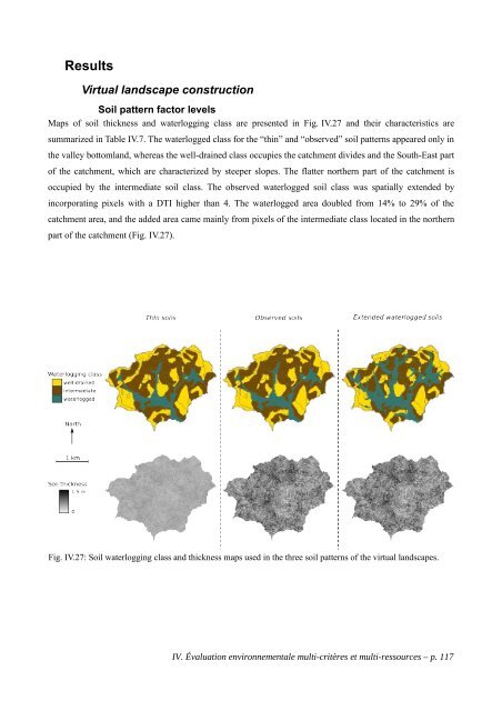
- Page 115: TNT2 simulations TNT2 calibration w
- Page 119 and 120: The NST transformations of measured
- Page 121 and 122: Cropping system factor levels Fig.
- Page 123 and 124: Scenario comparison and analysis St
- Page 125 and 126: Exploratory analysis of the simulat
- Page 127 and 128: The variance of all simulation resu
- Page 129 and 130: The effects of the factor levels va
- Page 131 and 132: higher denitrification rates, thus
- Page 133 and 134: Conclusion The study develops innov
- Page 135 and 136: Gabrielle B., B. Mary, R. Roche, P.
- Page 137 and 138: Chapitre V Conclusion générale
- Page 139 and 140: Chapitre V : Conclusion générale
- Page 141 and 142: par le système de culture ; − au
- Page 143 and 144: La plateforme Qualscape Les modules
- Page 145 and 146: Cependant, afin de maintenir un cer
- Page 147 and 148: Perspectives - de l’évaluation e
- Page 149 and 150: Bibliographie générale
- Page 151 and 152: Bibliographie générale Aarts H.F.
- Page 153 and 154: Deffontaines, J.P., C. Thenail, J.
- Page 155 and 156: in considering landscape trajectori
- Page 157 and 158: Ecosystems & Environment, 120 (2-4)
- Page 159 and 160: on global change research. 124 p. U
- Page 161: Annexes Annexes I : Article soumis
- Page 165 and 166: Annexes I : Application d’une mod
- Page 167 and 168:
Application of virtual landscape mo
- Page 169 and 170:
Introduction The increasing develop
- Page 171 and 172:
Material and methods Construction o
- Page 173 and 174:
Fig. A.I.35: Construction of the in
- Page 175 and 176:
Virtual landscape evolution Three i
- Page 177 and 178:
Fertilization practices We consider
- Page 179 and 180:
PEi,y= PexportYcrop = PexportN(mean
- Page 181 and 182:
RMSE= 1 N Year 1 N Realization N
- Page 183 and 184:
The rules we followed to interpret
- Page 185 and 186:
The sill of the experimental variog
- Page 187 and 188:
Strategy evaluation Accuracy assess
- Page 189 and 190:
− samples stratified by landuse (
- Page 191 and 192:
est design worst design BIAS curren
- Page 193:
Papritz A. and R. Webster. 1995. Es
- Page 197 and 198:
Annexes II : Matrices de probabilit
- Page 199 and 200:
Arbres de décision utilisés par S
- Page 201 and 202:
Fig. A.II.43 : Ensemble des parcell
- Page 203 and 204:
Fig. A.II.45 : Ensemble des parcell
- Page 205:
Arbre de décision utilisé pour si
- Page 208 and 209:
1. Exemple de fichier texte produit
- Page 210 and 211:
Méthode principale de manipulation