La haute vallée de la Saine - DREAL Franche-Comté
La haute vallée de la Saine - DREAL Franche-Comté
La haute vallée de la Saine - DREAL Franche-Comté

You also want an ePaper? Increase the reach of your titles
YUMPU automatically turns print PDFs into web optimized ePapers that Google loves.
Section C4<br />
<strong>La</strong> route départementale 17 <strong>de</strong> Nozeroy aux<br />
P<strong>la</strong>nches.<br />
De l’angle nord <strong>de</strong> <strong>la</strong> parcelle 554, une ligne<br />
fictive jusqu’à l’angle est <strong>de</strong> <strong>la</strong> parcelle 555.<br />
<strong>La</strong> voie communale n° 2 dite <strong>de</strong> Poutin jusqu’à sa<br />
d’Entre-Côtes jusqu’à sa rencontre avec le chemin<br />
<strong>de</strong> Chalesmes.<br />
Le chemin <strong>de</strong> Chalesmes.<br />
Le chemin <strong>de</strong> Foncine-le-Haut aux Chalesmes.<br />
Le chemin <strong>de</strong> <strong>la</strong> Fontaine <strong>de</strong> <strong>la</strong> Loge.<br />
<strong>La</strong> limite nord-ouest <strong>de</strong> <strong>la</strong> section AH.<br />
Tableau d’assemb<strong>la</strong>ge<br />
<strong>La</strong> limite est <strong>de</strong> <strong>la</strong> section A4 jusqu’à <strong>la</strong> limite<br />
communale <strong>de</strong> Foncine-le-Bas.<br />
commune <strong>de</strong> foncine-le-bas<br />
Section B7<br />
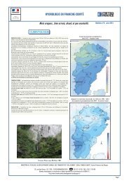
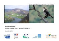
<strong>La</strong> <strong>haute</strong> <strong>vallée</strong> <strong>de</strong> <strong>la</strong> <strong>Saine</strong><br />
rencontre avec <strong>la</strong> section C5.<br />
<strong>La</strong> limite communale <strong>de</strong>s P<strong>la</strong>nches avec <strong>la</strong> commune<br />
Section AI<br />
<strong>de</strong> Foncine-le-Haut jusqu’au bief du Bouchon.<br />
Tableau d’assemb<strong>la</strong>ge<br />
<strong>La</strong> limite nord <strong>de</strong> <strong>la</strong> section AI.<br />
Le bief du Bouchon, jusqu’à l’angle nord <strong>de</strong> <strong>la</strong><br />
<strong>La</strong> limite nord-ouest <strong>de</strong> <strong>la</strong> section C5.<br />
<strong>La</strong> limite nord-est <strong>de</strong> <strong>la</strong> parcelle n° 24.<br />
parcelle n° 992.<br />
<strong>La</strong> limite communale nord-est jusqu’à<br />
<strong>La</strong> limite est <strong>de</strong> <strong>la</strong> parcelle n° 18.<br />
L’est <strong>de</strong> <strong>la</strong> parcelle 992 et son prolongement<br />
l’intersection <strong>de</strong>s limites communales <strong>de</strong><br />
<strong>La</strong> limite sud <strong>de</strong> <strong>la</strong> section AI.<br />
jusqu’à <strong>la</strong> limite nord <strong>de</strong> <strong>la</strong> parcelle n° 1001.<br />
Chalesmes, <strong>de</strong>s P<strong>la</strong>nches-en-Montagne et <strong>de</strong><br />
<strong>La</strong> traversée <strong>de</strong> <strong>la</strong> <strong>Saine</strong>.<br />
Le chemin du Bois.<br />
Foncine-le-Haut.<br />
<strong>La</strong> rive ouest <strong>de</strong> <strong>la</strong> <strong>Saine</strong>.<br />
Sur une distance mesurée <strong>de</strong> 110 mètres sur <strong>la</strong><br />
Les limites sud-est et sud-ouest <strong>de</strong> <strong>la</strong> parcelle n° 17.<br />
Section B6<br />
section A3.<br />
<strong>La</strong> limite sud-est <strong>de</strong>s parcelles n° 13 et 14.<br />
<strong>La</strong> limite entre <strong>la</strong> section B7 et <strong>la</strong> section B6<br />
jusqu’à l’angle nord <strong>de</strong> <strong>la</strong> parcelle n° 921.<br />
Commune <strong>de</strong> foncine-le-haut<br />
Section AH<br />
Les limites est et sud <strong>de</strong> <strong>la</strong> parcelle n° 921.<br />
Section A4<br />
<strong>La</strong> limite sud <strong>de</strong>s parcelles n° 35 et 41.<br />
<strong>La</strong> limite nord-est <strong>de</strong>s lieux-dits « Sur le <strong>La</strong>tet »<br />
Le chemin <strong>de</strong> Foncine-le-Haut aux Chalesmes.<br />
Section B1<br />
et « Champ <strong>La</strong>rge ».<br />
<strong>La</strong> limite nord <strong>de</strong>s parcelles n° 17 et 18.<br />
Section B<br />
<strong>La</strong> limite est <strong>de</strong> <strong>la</strong> parcelle n° 17.<br />
Tableau d’assemb<strong>la</strong>ge<br />
Le chemin rural <strong>de</strong> Chalesmes à Foncine-le-Haut.<br />
<strong>La</strong> traversée <strong>de</strong> <strong>la</strong> rivière.<br />
Le chemin <strong>de</strong> <strong>de</strong>sserte longeant le ruisseau<br />
<strong>La</strong> limite sud <strong>de</strong> <strong>la</strong> parcelle n° 6.<br />
<strong>La</strong> limite sud du lieu-dit « Champ du Bois ».<br />
37